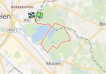
![](/images/other/stat-length.png)
![Excursión Senderismo Malinas - Mechels Broek - Photo](https://media.geolcdn.com/t/1900/400/9bcb37dd-3951-4aca-95ae-228b9c6b487f.jpg&format=pjpeg&maxdim=2)
Mechels Broek
Au fil de nos découvertes
« L’heure de la fin des découvertes ne sonne jamais. » Colette GUIDE+
![Longitud](/images/other/stat-length.png)
![Altitud máxima](https://static1.geolcdn.com/siteimages/upload/files/1508320355ic_sort_altitude_max_24dp.png)
![Desnivel positivo](https://static1.geolcdn.com/siteimages/upload/files/1508320355ic_sort_den_pos_24dp.png)
![Km-Effort](/images/other/stat-length.png)
![Altitud mínima](https://static1.geolcdn.com/siteimages/upload/files/1508320355ic_sort_altitude_min_24dp.png)
![Desnivel negativo](https://static1.geolcdn.com/siteimages/upload/files/1508320355ic_sort_den_neg_24dp.png)
![Boucle](https://static1.geolcdn.com/siteimages/upload/files/16400158638029165_repeat_loop_refresh_sync_direction_icon.png)
![Senderismo](https://static1.geolcdn.com/sitytour/trail-icons/101.png)
1h17
Dificultad : Fácil
![Escanee este código QR para abrir la excursión en la aplicación SityTrail](https://capi.geolives.com/qq0zvz2zws4bq2lad0pu/sitytour/trails/3864323/qr.png?size=200)
Aplicación GPS de excursión GRATIS
A propósito
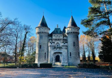
Ruta Senderismo de 5,4 km a descubrir en Flandes, Amberes, Malinas. Esta ruta ha sido propuesta por Au fil de nos découvertes.
Descripción
- À 20 minutes de Bruxelles 😍
🅿️ Départ et Parking:
Parking de Nekker
Plattebeekstraat
2800 Mechelen
(Au rond point prendre la 3e sortie et le début de la promenade se fait à droite)
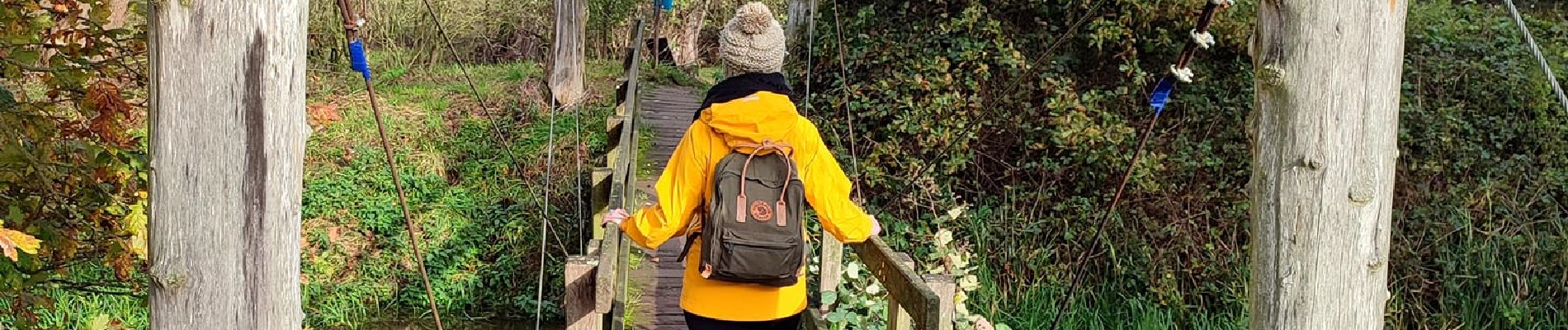
🚶Niveau facile
▶️ Suivre la balise "A.S. adventure avec une flèche bleue"
🥾 Prévoir de bonnes chaussures de marche.
⚠️ Les chemins peuvent vite être boueux
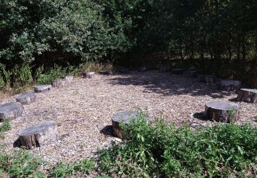
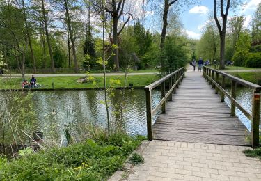
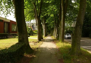
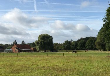
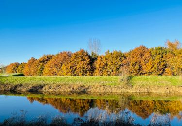
Cette jolie promenade vous emmène en forêt, dans les campagnes & le long de l'eau. 🌱🌳🍄
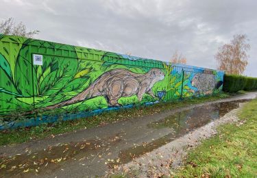
Vous passerez sur de petits ponts, des caillebotis & pourrez observer de nombreux animaux/oiseaux.🐄🐦⬛🦆🐸
Possibilités de pique-niquer. 🥪🍴
Chiens autorisés. 🐩🐶🐕
Convient pour les enfants . 👱👱♂️
Ne convient pas pour les poussettes et personnes à mobilité réduite car il y a des escaliers et des tourniquets mais il est possible de se promener le long de l'eau sans problème. 👨🦽👩🦽👶
N'hésitez pas à aller faire un tour sur notre site internet : www.aufildenosdecouvertes.com
Instagram :
https://www.instagram.com/au_fil_de_nos_decouvertes
Localización
Comentarios
Excursiones cerca
![Excursión A pie Malinas - Mechels Broek A. S. Adventureroute - Photo](https://media.geolcdn.com/t/375/260/93d6dbbd-a75f-4ec7-9bd1-e2b544fc0532.jpeg&format=jpg&maxdim=2)
![A pie A pie](https://static1.geolcdn.com/sitytour/trail-icons/100.png)
A pie
![](/images/other/stat-length.png)
![](https://static1.geolcdn.com/siteimages/upload/files/16400158638029165_repeat_loop_refresh_sync_direction_icon.png)
![Excursión Senderismo Malinas - S-GR Dijleland : Muizen - Mechelen - Eppegem - Photo](https://media.geolcdn.com/t/375/260/bf0307c6-7818-44b7-a71f-d4ed30d79703.jpeg&format=jpg&maxdim=2)
![Senderismo Senderismo](https://static1.geolcdn.com/sitytour/trail-icons/101.png)
Senderismo
![](/images/other/stat-length.png)
![](https://static1.geolcdn.com/siteimages/upload/files/16400158638029165_repeat_loop_refresh_sync_direction_icon.png)
![Excursión Senderismo Sint-Katelijne-Waver - waversebossen/Natuurpunt/St.Katelijne Waver - Photo](https://media.geolcdn.com/t/375/260/43d9684e-c64f-4184-b53f-7aac08166f6a.jpg&format=jpg&maxdim=2)
![Senderismo Senderismo](https://static1.geolcdn.com/sitytour/trail-icons/101.png)
Senderismo
![](/images/other/stat-length.png)
![](https://static1.geolcdn.com/siteimages/upload/files/16400158638029165_repeat_loop_refresh_sync_direction_icon.png)
![Excursión Senderismo Malinas - Malines ouest 18,3 km - Photo](https://media.geolcdn.com/t/375/260/9f492b71-0eb3-460c-aa58-29536b7e1526.jpg&format=jpg&maxdim=2)
![Senderismo Senderismo](https://static1.geolcdn.com/sitytour/trail-icons/101.png)
Senderismo
![](/images/other/stat-length.png)
![](https://static1.geolcdn.com/siteimages/upload/files/16400158638029165_repeat_loop_refresh_sync_direction_icon.png)
![Excursión A pie Zemst - 5 km looproute - Photo](https://media.geolcdn.com/t/375/260/5bf54057-1682-421e-b778-f05b4be0d342.jpeg&format=jpg&maxdim=2)
![A pie A pie](https://static1.geolcdn.com/sitytour/trail-icons/100.png)
A pie
![](/images/other/stat-length.png)
![](https://static1.geolcdn.com/siteimages/upload/files/16400158638029165_repeat_loop_refresh_sync_direction_icon.png)
![Excursión Senderismo Malinas - Malines out and in 20 km - Photo](https://media.geolcdn.com/t/375/260/feebb084-0339-4f27-8695-b58d3cb5a801.jpg&format=jpg&maxdim=2)
![Senderismo Senderismo](https://static1.geolcdn.com/sitytour/trail-icons/101.png)
Senderismo
![](/images/other/stat-length.png)
![](https://static1.geolcdn.com/siteimages/upload/files/16400158638029165_repeat_loop_refresh_sync_direction_icon.png)
![Excursión Senderismo Bonheiden - Malines les marais moeras 21 km - Photo](https://media.geolcdn.com/t/375/260/cdb70a8a-04c8-4736-88ef-c7450fb13e45.jpg&format=jpg&maxdim=2)
![Senderismo Senderismo](https://static1.geolcdn.com/sitytour/trail-icons/101.png)
Senderismo
![](/images/other/stat-length.png)
![](https://static1.geolcdn.com/siteimages/upload/files/16400158638029165_repeat_loop_refresh_sync_direction_icon.png)
![Excursión Senderismo Bonheiden - Zellaerpad - Photo](https://media.geolcdn.com/t/375/260/86f99e1a-df8d-4292-88ba-86f046d10e03.jpeg&format=jpg&maxdim=2)
![Senderismo Senderismo](https://static1.geolcdn.com/sitytour/trail-icons/101.png)
![Excursión Senderismo Malinas - Groene Natuurpuntwandeling Barebeekvallei - Mechelen (Muizen) - Photo](https://media.geolcdn.com/t/375/260/42e677bf-867b-4e1d-9e90-f48f08bd1d2a.jpeg&format=jpg&maxdim=2)
![Senderismo Senderismo](https://static1.geolcdn.com/sitytour/trail-icons/101.png)
Senderismo
![](/images/other/stat-length.png)
![](https://static1.geolcdn.com/siteimages/upload/files/16400158638029165_repeat_loop_refresh_sync_direction_icon.png)