![](/images/other/stat-length.png)
![Excursión Senderismo Cuges-les-Pins - du col de l'ange à la chapelle St Martin : Gémenos - Photo](https://media.geolcdn.com/t/1900/400/ext.pjpeg?maxdim=2&url=https%3A%2F%2Fstatic1.geolcdn.com%2Fsiteimages%2Fupload%2Ffiles%2F1553511878bg_sport_marche.png)
du col de l'ange à la chapelle St Martin : Gémenos
eaea7charles
Usuario
![Longitud](/images/other/stat-length.png)
Longitud
11,7 km
![Altitud máxima](https://static1.geolcdn.com/siteimages/upload/files/1508320355ic_sort_altitude_max_24dp.png)
Altitud máxima
490 m
![Desnivel positivo](https://static1.geolcdn.com/siteimages/upload/files/1508320355ic_sort_den_pos_24dp.png)
Desnivel positivo
548 m
![Km-Effort](/images/other/stat-length.png)
Km-Effort
19 km
![Altitud mínima](https://static1.geolcdn.com/siteimages/upload/files/1508320355ic_sort_altitude_min_24dp.png)
Altitud mínima
216 m
![Desnivel negativo](https://static1.geolcdn.com/siteimages/upload/files/1508320355ic_sort_den_neg_24dp.png)
Desnivel negativo
548 m
![Boucle](https://static1.geolcdn.com/siteimages/upload/files/16400158638029165_repeat_loop_refresh_sync_direction_icon.png)
Boucle
Sí
Fecha de creación :
2023-11-08 09:18:36.865
Última modificación :
2023-11-08 09:27:23.615
![Senderismo](https://static1.geolcdn.com/sitytour/trail-icons/101.png)
4h18
Dificultad : Difícil
![Escanee este código QR para abrir la excursión en la aplicación SityTrail](https://capi.geolives.com/qq0zvz2zws4bq2lad0pu/sitytour/trails/3861360/qr.png?size=200)
Aplicación GPS de excursión GRATIS
A propósito
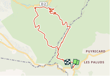
Ruta Senderismo de 11,7 km a descubrir en Provenza-Alpes-Costa Azul, Bocas del Ródano, Cuges-les-Pins. Esta ruta ha sido propuesta por eaea7charles.
Descripción
départ du parking du col de l'ange sur la RN8 vers le sommet du Brigou sur le GR 98, puis la chapelle St Martin le long du torrent de fouge. Retour vers le mont cruvelier
Localización
País:
France
Región :
Provenza-Alpes-Costa Azul
Departamento/provincia :
Bocas del Ródano
Municipio :
Cuges-les-Pins
Localidad:
Unknown
Salida:(Dec)
Salida:(UTM)
716681 ; 4793793 (31T) N.
Comentarios
Excursiones cerca
![Excursión Senderismo Roquefort-la-Bédoule - Grand Caunet, le Montounier - Photo](https://media.geolcdn.com/t/375/260/6da96041-d8db-45b9-9840-88b8ee06ae33.jpg&format=jpg&maxdim=2)
![Senderismo Senderismo](https://static1.geolcdn.com/sitytour/trail-icons/101.png)
Grand Caunet, le Montounier
Senderismo
Medio
(1)
Roquefort-la-Bédoule,
Provenza-Alpes-Costa Azul,
Bocas del Ródano,
France
![](/images/other/stat-length.png)
16,5 km | 24 km-effort
6h 0min
![](https://static1.geolcdn.com/siteimages/upload/files/16400158638029165_repeat_loop_refresh_sync_direction_icon.png)
Sí
![Excursión Senderismo Ceyreste - Autour du Montounier 2eme version - Photo](https://media.geolcdn.com/t/375/260/aea50e59-26c4-4704-b6d5-ac40178213cc.jpg&format=jpg&maxdim=2)
![Senderismo Senderismo](https://static1.geolcdn.com/sitytour/trail-icons/101.png)
Autour du Montounier 2eme version
Senderismo
Medio
(1)
Ceyreste,
Provenza-Alpes-Costa Azul,
Bocas del Ródano,
France
![](/images/other/stat-length.png)
15,7 km | 24 km-effort
6h 0min
![](https://static1.geolcdn.com/siteimages/upload/files/16400158638029165_repeat_loop_refresh_sync_direction_icon.png)
Sí
![Excursión Senderismo Roquefort-la-Bédoule - SityTrail - Grand Caunet, Cabanons, Vigie , Grotte Raymond, Ruines roquefort, Chapelle St andré - Photo](https://media.geolcdn.com/t/375/260/f9c0beb6-6483-4b14-ba76-b33fa5e2208b.jpg&format=jpg&maxdim=2)
![Senderismo Senderismo](https://static1.geolcdn.com/sitytour/trail-icons/101.png)
SityTrail - Grand Caunet, Cabanons, Vigie , Grotte Raymond, Ruines roquefort,...
Senderismo
Fácil
(1)
Roquefort-la-Bédoule,
Provenza-Alpes-Costa Azul,
Bocas del Ródano,
France
![](/images/other/stat-length.png)
14,2 km | 19,9 km-effort
6h 0min
![](https://static1.geolcdn.com/siteimages/upload/files/16400158638029165_repeat_loop_refresh_sync_direction_icon.png)
Sí
![Excursión Senderismo Le Castellet - SityTrail - 2361987 - begude - Photo](https://media.geolcdn.com/t/375/260/dbe90af6-979b-4145-807f-db327fb40379.jpg&format=jpg&maxdim=2)
![Senderismo Senderismo](https://static1.geolcdn.com/sitytour/trail-icons/101.png)
SityTrail - 2361987 - begude
Senderismo
Medio
(1)
Le Castellet,
Provenza-Alpes-Costa Azul,
Var,
France
![](/images/other/stat-length.png)
11,5 km | 15,1 km-effort
4h 0min
![](https://static1.geolcdn.com/siteimages/upload/files/16400158638029165_repeat_loop_refresh_sync_direction_icon.png)
Sí
![Excursión Senderismo Gémenos - St Pons Le Fauge Glacière - Photo](https://media.geolcdn.com/t/375/260/ext.jpg?maxdim=2&url=https%3A%2F%2Fservices.sitytrail.com%2FGeolivesWS%2FDownloadMedia.ashx%3FTrailID%3D954893%26Media%3Dfix__20180430171638.jpg)
![Senderismo Senderismo](https://static1.geolcdn.com/sitytour/trail-icons/101.png)
St Pons Le Fauge Glacière
Senderismo
Difícil
(1)
Gémenos,
Provenza-Alpes-Costa Azul,
Bocas del Ródano,
France
![](/images/other/stat-length.png)
11,7 km | 18,6 km-effort
3h 56min
![](https://static1.geolcdn.com/siteimages/upload/files/16400158638029165_repeat_loop_refresh_sync_direction_icon.png)
Sí
![Excursión Senderismo Roquefort-la-Bédoule - la petite sainte baume - Photo](https://media.geolcdn.com/t/375/260/24f466c4-80fb-4267-898b-b6a75ae27664.jpg&format=jpg&maxdim=2)
![Senderismo Senderismo](https://static1.geolcdn.com/sitytour/trail-icons/101.png)
la petite sainte baume
Senderismo
Fácil
(1)
Roquefort-la-Bédoule,
Provenza-Alpes-Costa Azul,
Bocas del Ródano,
France
![](/images/other/stat-length.png)
13,9 km | 19,3 km-effort
5h 37min
![](https://static1.geolcdn.com/siteimages/upload/files/16400158638029165_repeat_loop_refresh_sync_direction_icon.png)
Sí
![Excursión Senderismo Gémenos - autour de Saint pons - Photo](https://media.geolcdn.com/t/375/260/ext.jpg?maxdim=2&url=https%3A%2F%2Fservices.sitytrail.com%2FGeolivesWS%2FDownloadMedia.ashx%3FTrailID%3D723506%26Media%3Dfix__20170330154755.jpg)
![Senderismo Senderismo](https://static1.geolcdn.com/sitytour/trail-icons/101.png)
autour de Saint pons
Senderismo
Fácil
(1)
Gémenos,
Provenza-Alpes-Costa Azul,
Bocas del Ródano,
France
![](/images/other/stat-length.png)
11,6 km | 16,1 km-effort
3h 46min
![](https://static1.geolcdn.com/siteimages/upload/files/16400158638029165_repeat_loop_refresh_sync_direction_icon.png)
Sí
![Excursión Bici de montaña Gémenos - Gémenos - La Grande Baume - Photo](https://media.geolcdn.com/t/375/260/ext.jpg?maxdim=2&url=https%3A%2F%2Fservices.sitytrail.com%2FGeolivesWS%2FDownloadMedia.ashx%3FTrailID%3D104196%26Media%3D7328_1.jpg)
![Bici de montaña Bici de montaña](https://static1.geolcdn.com/sitytour/trail-icons/202.png)
Gémenos - La Grande Baume
Bici de montaña
Difícil
(1)
Gémenos,
Provenza-Alpes-Costa Azul,
Bocas del Ródano,
France
![](/images/other/stat-length.png)
18,4 km | 29 km-effort
3h 30min
![](https://static1.geolcdn.com/siteimages/upload/files/16400158638029165_repeat_loop_refresh_sync_direction_icon.png)
Sí
![Excursión Senderismo Roquefort-la-Bédoule - Barres de Font Blanche - Photo](https://media.geolcdn.com/t/375/260/ext.jpg?maxdim=2&url=https%3A%2F%2Fservices.sitytrail.com%2FGeolivesWS%2FDownloadMedia.ashx%3FTrailID%3D103784%26Media%3D6554_1.jpg)
![Senderismo Senderismo](https://static1.geolcdn.com/sitytour/trail-icons/101.png)
Barres de Font Blanche
Senderismo
Medio
(1)
Roquefort-la-Bédoule,
Provenza-Alpes-Costa Azul,
Bocas del Ródano,
France
![](/images/other/stat-length.png)
10,3 km | 14,4 km-effort
2h 19min
![](https://static1.geolcdn.com/siteimages/upload/files/16400158638029165_repeat_loop_refresh_sync_direction_icon.png)
Sí