![](/images/other/stat-length.png)
![Excursión Senderismo Guérande - Kercabus - Photo](https://media.geolcdn.com/t/1900/400/ext.pjpeg?maxdim=2&url=https%3A%2F%2Fstatic1.geolcdn.com%2Fsiteimages%2Fupload%2Ffiles%2F1553511878bg_sport_marche.png)
Kercabus
neoroll44
Usuario
![Longitud](/images/other/stat-length.png)
![Altitud máxima](https://static1.geolcdn.com/siteimages/upload/files/1508320355ic_sort_altitude_max_24dp.png)
![Desnivel positivo](https://static1.geolcdn.com/siteimages/upload/files/1508320355ic_sort_den_pos_24dp.png)
![Km-Effort](/images/other/stat-length.png)
![Altitud mínima](https://static1.geolcdn.com/siteimages/upload/files/1508320355ic_sort_altitude_min_24dp.png)
![Desnivel negativo](https://static1.geolcdn.com/siteimages/upload/files/1508320355ic_sort_den_neg_24dp.png)
![Boucle](https://static1.geolcdn.com/siteimages/upload/files/16400158638029165_repeat_loop_refresh_sync_direction_icon.png)
![Senderismo](https://static1.geolcdn.com/sitytour/trail-icons/101.png)
2h30
Dificultad : Fácil
![Escanee este código QR para abrir la excursión en la aplicación SityTrail](https://capi.geolives.com/qq0zvz2zws4bq2lad0pu/sitytour/trails/385015/qr.png?size=200)
Aplicación GPS de excursión GRATIS
A propósito
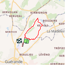
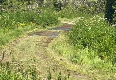
Ruta Senderismo de 8,6 km a descubrir en Países del Loira, Loira-Atlántico, Guérande. Esta ruta ha sido propuesta por neoroll44.
Descripción
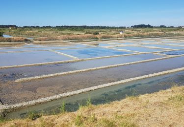
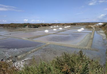
Empruntez le sentier qui longe le camping de Bréhadour par un chemin dans la campagne en laissant sur votre droite le manoir de Cosquer. Au premier croisement de sentier, continuez tout droit. Au carrefour, continuez tout droit en prenant la route goudronnée vers Savenas pendant 300 mètres. Prenez le sentier qui oblique à droite. On suit le tracé d’une ancienne voie romaine qui est aussi le GR3 (sentier de grande randonnée balisé rouge et blanc). Continuez sur le sentier, entre ajoncs, bouleaux, chênes pédonculés et diverses variétés. Ouvrez grand les yeux, à la patted’oie, prenez le sentier qui monte très légèrement vers la droite ve rs l’étang de Kercabus. Il n’est pas bien balisé. Le sentier commence avec des gros pavés de pierre au sol. Poursuivre le sentier étroit. Sur votre gauche, admirez les eaux tranquilles de l’étang de Kercabus. Endroit paisible caché entre les arbres… Encore quelques mètres en montée, et vous passez devant le moulin à petits pied qui date du XVe siècle. Au carrefour suivant, prendre à gauche la route goudronnée sur 300 mètres. Au croisement, tournez à droite pour arriver à Kerhas. Prendre à droite le chemin en face de la belle chaumière ancienne. Au premier carrefour, continuez tout droit. Cent mètres après le croisement suivant, prendre le sentier de terre sur la droite. Au carrefour du Grand Poissevin, prendre à droite puis immédiatement à gauche la rue des Coideaux. Au croisement suivant, prendre à droite vers Ville Blanche. Poursuivez la route qui oblique à gauche, passez devant le gîte Les Colombes de Ville Blanche. Au premier croisement, prenez à droite vers le golf. Longez le golf. Au croisement, reprenez à gauche le chemin initial pour retourner vers Guérande et retrouver le camping de Brehadour. Allez… Encore quelques centaines de mètres et vous aurez bouclé la boucle ! Vous avez le droit de retourner vous réchauffer !
Localización
Comentarios
Excursiones cerca
![Excursión Senderismo Guérande - De Guérande à La Turballe par les marais - Photo](https://media.geolcdn.com/t/375/260/ext.jpg?maxdim=2&url=https%3A%2F%2Fstatic1.geolcdn.com%2Fsiteimages%2Fupload%2Ffiles%2F1553511878bg_sport_marche.png)
![Senderismo Senderismo](https://static1.geolcdn.com/sitytour/trail-icons/101.png)
Senderismo
![](/images/other/stat-length.png)
![](https://static1.geolcdn.com/siteimages/upload/files/16400158638029165_repeat_loop_refresh_sync_direction_icon.png)
![Excursión Senderismo Guérande - Guerande La Turballe et retour - Photo](https://media.geolcdn.com/t/375/260/18c14a3c-15ca-4d7c-a32e-6898f74dab5a.jpg&format=jpg&maxdim=2)
![Senderismo Senderismo](https://static1.geolcdn.com/sitytour/trail-icons/101.png)
Senderismo
![](/images/other/stat-length.png)
![](https://static1.geolcdn.com/siteimages/upload/files/16400158638029165_repeat_loop_refresh_sync_direction_icon.png)
![Excursión Bicicleta híbrida Guérande - 2023-07-25 Marais salants de Guérande - Photo](https://media.geolcdn.com/t/375/260/0a56980d-e337-4fe5-a1ee-9b7bab486125.jpg&format=jpg&maxdim=2)
![Bicicleta híbrida Bicicleta híbrida](https://static1.geolcdn.com/sitytour/trail-icons/203.png)
Bicicleta híbrida
![](/images/other/stat-length.png)
![](https://static1.geolcdn.com/siteimages/upload/files/16400158638029165_repeat_loop_refresh_sync_direction_icon.png)
![Excursión Bici de montaña Guérande - Le Croisic - Photo](https://media.geolcdn.com/t/375/260/3c586856-2120-4198-84d3-f552da8ad210.jpg&format=jpg&maxdim=2)
![Bici de montaña Bici de montaña](https://static1.geolcdn.com/sitytour/trail-icons/202.png)
Bici de montaña
![](/images/other/stat-length.png)
![](https://static1.geolcdn.com/siteimages/upload/files/16400158638029165_repeat_loop_refresh_sync_direction_icon.png)
![Excursión sport Guérande - Guerande/la turballe - Photo](https://media.geolcdn.com/t/375/260/f6ba62c7-57cd-4fef-af9c-ee5a6867013b.jpg&format=jpg&maxdim=2)
sport
![](/images/other/stat-length.png)
![](https://static1.geolcdn.com/siteimages/upload/files/16400158638029165_repeat_loop_refresh_sync_direction_icon.png)
![Excursión Senderismo Guérande - Guérande 8 km - Photo](https://media.geolcdn.com/t/375/260/ext.jpg?maxdim=2&url=https%3A%2F%2Fstatic1.geolcdn.com%2Fsiteimages%2Fupload%2Ffiles%2F1553511878bg_sport_marche.png)
![Senderismo Senderismo](https://static1.geolcdn.com/sitytour/trail-icons/101.png)
Senderismo
![](/images/other/stat-length.png)
![](https://static1.geolcdn.com/siteimages/upload/files/16400158638029165_repeat_loop_refresh_sync_direction_icon.png)
![Excursión Senderismo Saint-Lyphard - LA BRIERE / KERHINET 14 10 2018 - Photo](https://media.geolcdn.com/t/375/260/ext.jpg?maxdim=2&url=https%3A%2F%2Fstatic1.geolcdn.com%2Fsiteimages%2Fupload%2Ffiles%2F1553511878bg_sport_marche.png)
![Senderismo Senderismo](https://static1.geolcdn.com/sitytour/trail-icons/101.png)
Senderismo
![](/images/other/stat-length.png)
![](https://static1.geolcdn.com/siteimages/upload/files/16400158638029165_repeat_loop_refresh_sync_direction_icon.png)
![Excursión Senderismo Guérande - AUTOUR DU GOLF DE GUÉRANDE - Photo](https://media.geolcdn.com/t/375/260/ext.jpg?maxdim=2&url=https%3A%2F%2Fstatic1.geolcdn.com%2Fsiteimages%2Fupload%2Ffiles%2F1553511878bg_sport_marche.png)
![Senderismo Senderismo](https://static1.geolcdn.com/sitytour/trail-icons/101.png)
Senderismo
![](/images/other/stat-length.png)
![](https://static1.geolcdn.com/siteimages/upload/files/16400158638029165_repeat_loop_refresh_sync_direction_icon.png)
![Excursión Senderismo Saint-Lyphard - Kerhinet 17 - Photo](https://media.geolcdn.com/t/375/260/ext.jpg?maxdim=2&url=https%3A%2F%2Fstatic1.geolcdn.com%2Fsiteimages%2Fupload%2Ffiles%2F1553511878bg_sport_marche.png)
![Senderismo Senderismo](https://static1.geolcdn.com/sitytour/trail-icons/101.png)
Senderismo
![](/images/other/stat-length.png)
![](https://static1.geolcdn.com/siteimages/upload/files/16400158638029165_repeat_loop_refresh_sync_direction_icon.png)