![](/images/other/stat-length.png)
![Excursión Senderismo Glandage - Le Jocou 2 - Photo](https://media.geolcdn.com/t/1900/400/3db953da-6976-42b8-b004-e2f45e4d2956.jpg&format=pjpeg&maxdim=2)
Le Jocou 2
Marco05
Usuario GUIDE
![Longitud](/images/other/stat-length.png)
Longitud
8,5 km
![Altitud máxima](https://static1.geolcdn.com/siteimages/upload/files/1508320355ic_sort_altitude_max_24dp.png)
Altitud máxima
2023 m
![Desnivel positivo](https://static1.geolcdn.com/siteimages/upload/files/1508320355ic_sort_den_pos_24dp.png)
Desnivel positivo
722 m
![Km-Effort](/images/other/stat-length.png)
Km-Effort
18,1 km
![Altitud mínima](https://static1.geolcdn.com/siteimages/upload/files/1508320355ic_sort_altitude_min_24dp.png)
Altitud mínima
1292 m
![Desnivel negativo](https://static1.geolcdn.com/siteimages/upload/files/1508320355ic_sort_den_neg_24dp.png)
Desnivel negativo
721 m
![Boucle](https://static1.geolcdn.com/siteimages/upload/files/16400158638029165_repeat_loop_refresh_sync_direction_icon.png)
Boucle
Sí
Fecha de creación :
2023-10-23 08:09:53.54
Última modificación :
2023-10-24 09:33:41.708
![Senderismo](https://static1.geolcdn.com/sitytour/trail-icons/101.png)
4h00
Dificultad : Difícil
![Escanee este código QR para abrir la excursión en la aplicación SityTrail](https://capi.geolives.com/qq0zvz2zws4bq2lad0pu/sitytour/trails/3848242/qr.png?size=200)
Aplicación GPS de excursión GRATIS
A propósito
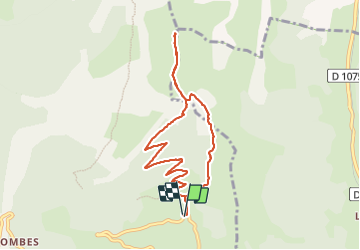
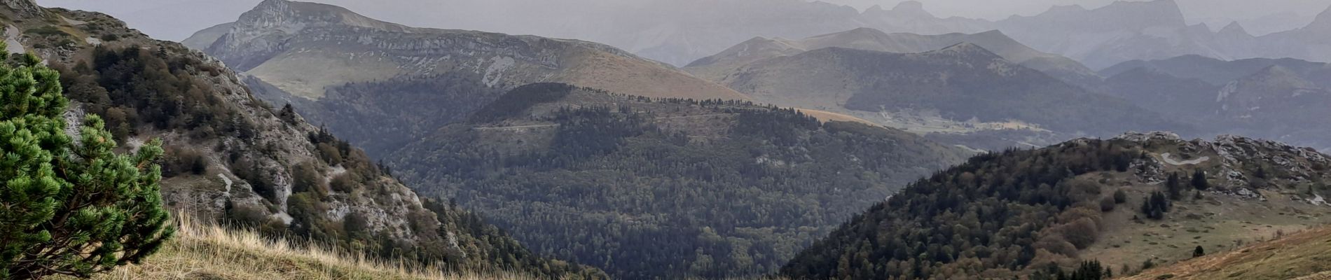
Ruta Senderismo de 8,5 km a descubrir en Auvergne-Rhône-Alpes, Drôme, Glandage. Esta ruta ha sido propuesta por Marco05.
Descripción
Même montée que sur le Jocou 1, mais une variante pour la decsente. Donc pas la grande boucle, car le vent était trop violent au sommet.
Localización
País:
France
Región :
Auvergne-Rhône-Alpes
Departamento/provincia :
Drôme
Municipio :
Glandage
Localidad:
Unknown
Salida:(Dec)
Salida:(UTM)
709813 ; 4953182 (31T) N.
Comentarios
Excursiones cerca
![Excursión Senderismo Lus-la-Croix-Haute - Pointe Feuillette - Photo](https://media.geolcdn.com/t/375/260/c32e652d-9142-443d-9f13-87284c6d10a4.jpg&format=jpg&maxdim=2)
![Senderismo Senderismo](https://static1.geolcdn.com/sitytour/trail-icons/101.png)
Pointe Feuillette
Senderismo
Difícil
Lus-la-Croix-Haute,
Auvergne-Rhône-Alpes,
Drôme,
France
![](/images/other/stat-length.png)
10,5 km | 20 km-effort
4h 36min
![](https://static1.geolcdn.com/siteimages/upload/files/16400158638029165_repeat_loop_refresh_sync_direction_icon.png)
Sí
![Excursión Senderismo Glandage - 2022-09-05_12h23m25_Le Jocou-col de Seysse 12km.gpx (2).xml - Photo](https://media.geolcdn.com/t/375/260/7fa8e50f-0ae3-4fbb-b69e-805ffe4b1242.jpg&format=jpg&maxdim=2)
![Senderismo Senderismo](https://static1.geolcdn.com/sitytour/trail-icons/101.png)
2022-09-05_12h23m25_Le Jocou-col de Seysse 12km.gpx (2).xml
Senderismo
Muy difícil
Glandage,
Auvergne-Rhône-Alpes,
Drôme,
France
![](/images/other/stat-length.png)
11,6 km | 24 km-effort
5h 27min
![](https://static1.geolcdn.com/siteimages/upload/files/16400158638029165_repeat_loop_refresh_sync_direction_icon.png)
Sí
![Excursión Senderismo Glandage - 2022-06-24_19h10m37_Le Jocou par crêtes des Amousières 10km.gpx.xml - Photo](https://media.geolcdn.com/t/375/260/eeeff28a-8806-426d-aef8-2ba384b53865.jpg&format=jpg&maxdim=2)
![Senderismo Senderismo](https://static1.geolcdn.com/sitytour/trail-icons/101.png)
2022-06-24_19h10m37_Le Jocou par crêtes des Amousières 10km.gpx.xml
Senderismo
Muy difícil
Glandage,
Auvergne-Rhône-Alpes,
Drôme,
France
![](/images/other/stat-length.png)
9,6 km | 22 km-effort
5h 9min
![](https://static1.geolcdn.com/siteimages/upload/files/16400158638029165_repeat_loop_refresh_sync_direction_icon.png)
Sí
![Excursión Senderismo Glandage - Grimone-Le Jocou 12km - Photo](https://media.geolcdn.com/t/375/260/cd25f2bd-a51d-4184-be3b-7961b829b3e2.jpg&format=jpg&maxdim=2)
![Senderismo Senderismo](https://static1.geolcdn.com/sitytour/trail-icons/101.png)
Grimone-Le Jocou 12km
Senderismo
Difícil
Glandage,
Auvergne-Rhône-Alpes,
Drôme,
France
![](/images/other/stat-length.png)
12 km | 24 km-effort
6h 0min
![](https://static1.geolcdn.com/siteimages/upload/files/16400158638029165_repeat_loop_refresh_sync_direction_icon.png)
Sí
![Excursión Senderismo Lus-la-Croix-Haute - R48 - Gorges des Amayères - Photo](https://media.geolcdn.com/t/375/260/4bbc825f-a565-4275-9665-85da99118f1b.jpg&format=jpg&maxdim=2)
![Senderismo Senderismo](https://static1.geolcdn.com/sitytour/trail-icons/101.png)
R48 - Gorges des Amayères
Senderismo
Fácil
Lus-la-Croix-Haute,
Auvergne-Rhône-Alpes,
Drôme,
France
![](/images/other/stat-length.png)
10,3 km | 17,5 km-effort
3h 1min
![](https://static1.geolcdn.com/siteimages/upload/files/16400158638029165_repeat_loop_refresh_sync_direction_icon.png)
No
![Excursión Senderismo Lus-la-Croix-Haute - Le Rognon - Photo](https://media.geolcdn.com/t/375/260/ext.jpg?maxdim=2&url=https%3A%2F%2Fstatic1.geolcdn.com%2Fsiteimages%2Fupload%2Ffiles%2F1553511878bg_sport_marche.png)
![Senderismo Senderismo](https://static1.geolcdn.com/sitytour/trail-icons/101.png)
Le Rognon
Senderismo
Medio
(1)
Lus-la-Croix-Haute,
Auvergne-Rhône-Alpes,
Drôme,
France
![](/images/other/stat-length.png)
12,3 km | 22 km-effort
4h 33min
![](https://static1.geolcdn.com/siteimages/upload/files/16400158638029165_repeat_loop_refresh_sync_direction_icon.png)
Sí
![A pie A pie](https://static1.geolcdn.com/sitytour/trail-icons/100.png)
2024-04-17_Au fil du Buech
A pie
Fácil
Lus-la-Croix-Haute,
Auvergne-Rhône-Alpes,
Drôme,
France
![](/images/other/stat-length.png)
7,5 km | 12,2 km-effort
2h 45min
![](https://static1.geolcdn.com/siteimages/upload/files/16400158638029165_repeat_loop_refresh_sync_direction_icon.png)
Sí
![A pie A pie](https://static1.geolcdn.com/sitytour/trail-icons/100.png)
2024-04-16_Sucettes de Borne
A pie
Difícil
Glandage,
Auvergne-Rhône-Alpes,
Drôme,
France
![](/images/other/stat-length.png)
18,7 km | 32 km-effort
7h 11min
![](https://static1.geolcdn.com/siteimages/upload/files/16400158638029165_repeat_loop_refresh_sync_direction_icon.png)
Sí
![A pie A pie](https://static1.geolcdn.com/sitytour/trail-icons/100.png)
2024-04-15_L'Aupillon
A pie
Medio
Lus-la-Croix-Haute,
Auvergne-Rhône-Alpes,
Drôme,
France
![](/images/other/stat-length.png)
8,3 km | 14,5 km-effort
3h 17min
![](https://static1.geolcdn.com/siteimages/upload/files/16400158638029165_repeat_loop_refresh_sync_direction_icon.png)
Sí