![](/images/other/stat-length.png)
![Excursión Senderismo Mont-Albert - Tour du mont Ernest Laforce - Photo](https://media.geolcdn.com/t/1900/400/ext.pjpeg?maxdim=2&url=https%3A%2F%2Fstatic1.geolcdn.com%2Fsiteimages%2Fupload%2Ffiles%2F1553511878bg_sport_marche.png)
Tour du mont Ernest Laforce
s0c7
Usuario
![Longitud](/images/other/stat-length.png)
Longitud
7,8 km
![Altitud máxima](https://static1.geolcdn.com/siteimages/upload/files/1508320355ic_sort_altitude_max_24dp.png)
Altitud máxima
830 m
![Desnivel positivo](https://static1.geolcdn.com/siteimages/upload/files/1508320355ic_sort_den_pos_24dp.png)
Desnivel positivo
228 m
![Km-Effort](/images/other/stat-length.png)
Km-Effort
11,1 km
![Altitud mínima](https://static1.geolcdn.com/siteimages/upload/files/1508320355ic_sort_altitude_min_24dp.png)
Altitud mínima
578 m
![Desnivel negativo](https://static1.geolcdn.com/siteimages/upload/files/1508320355ic_sort_den_neg_24dp.png)
Desnivel negativo
303 m
![Boucle](https://static1.geolcdn.com/siteimages/upload/files/16400158638029165_repeat_loop_refresh_sync_direction_icon.png)
Boucle
No
Fecha de creación :
2023-09-18 19:33:00.63
Última modificación :
2023-10-15 10:51:31.751
![Senderismo](https://static1.geolcdn.com/sitytour/trail-icons/101.png)
1h15
Dificultad : Muy fácil
![Escanee este código QR para abrir la excursión en la aplicación SityTrail](https://capi.geolives.com/qq0zvz2zws4bq2lad0pu/sitytour/trails/3840664/qr.png?size=200)
Aplicación GPS de excursión GRATIS
A propósito
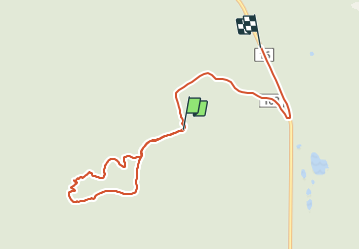
Ruta Senderismo de 7,8 km a descubrir en Quebec, La Haute-Gaspésie, Mont-Albert. Esta ruta ha sido propuesta por s0c7.
Descripción
Balade très facile avec un faible dénivelé donnant une vue 360° sur les monts du parc de Gaspésie.
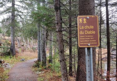
Vaut le détour...
Localización
País:
Canada
Región :
Quebec
Departamento/provincia :
La Haute-Gaspésie
Municipio :
Mont-Albert
Localidad:
Unknown
Salida:(Dec)
Salida:(UTM)
715137 ; 5423241 (19U) N.
Comentarios
Excursiones cerca
![Excursión Senderismo Mont-Albert - 2014-08-10 18:36:31 - Photo](https://media.geolcdn.com/t/375/260/ext.jpg?maxdim=2&url=https%3A%2F%2Fstatic1.geolcdn.com%2Fsiteimages%2Fupload%2Ffiles%2F1553511878bg_sport_marche.png)
![Senderismo Senderismo](https://static1.geolcdn.com/sitytour/trail-icons/101.png)
2014-08-10 18:36:31
Senderismo
Fácil
(1)
Mont-Albert,
Quebec,
La Haute-Gaspésie,
Canada
![](/images/other/stat-length.png)
4,5 km | 7 km-effort
1h 50min
![](https://static1.geolcdn.com/siteimages/upload/files/16400158638029165_repeat_loop_refresh_sync_direction_icon.png)
Sí
![Excursión Senderismo Mont-Albert - Chutes du diable - sentier du Mont Albert - Photo](https://media.geolcdn.com/t/375/260/d121818b-fc26-436e-8206-be39e17e7b8e.jpg&format=jpg&maxdim=2)
![Senderismo Senderismo](https://static1.geolcdn.com/sitytour/trail-icons/101.png)
Chutes du diable - sentier du Mont Albert
Senderismo
Medio
Mont-Albert,
Quebec,
La Haute-Gaspésie,
Canada
![](/images/other/stat-length.png)
6,9 km | 8,6 km-effort
1h 48min
![](https://static1.geolcdn.com/siteimages/upload/files/16400158638029165_repeat_loop_refresh_sync_direction_icon.png)
Sí
![Excursión Senderismo Mont-Albert - 2014-08-11 15:45:09 - Photo](https://media.geolcdn.com/t/375/260/ext.jpg?maxdim=2&url=https%3A%2F%2Fstatic1.geolcdn.com%2Fsiteimages%2Fupload%2Ffiles%2F1553511878bg_sport_marche.png)
![Senderismo Senderismo](https://static1.geolcdn.com/sitytour/trail-icons/101.png)
2014-08-11 15:45:09
Senderismo
Muy difícil
Mont-Albert,
Quebec,
La Haute-Gaspésie,
Canada
![](/images/other/stat-length.png)
16,8 km | 29 km-effort
7h 0min
![](https://static1.geolcdn.com/siteimages/upload/files/16400158638029165_repeat_loop_refresh_sync_direction_icon.png)
Sí
![Excursión Senderismo Mont-Albert - Wikiloc - Parc National de la Gaspésie - Sentier du Mont Richardson - Aller-retour - Photo](https://media.geolcdn.com/t/375/260/ext.jpg?maxdim=2&url=https%3A%2F%2Fstatic1.geolcdn.com%2Fsiteimages%2Fupload%2Ffiles%2F1553511878bg_sport_marche.png)
![Senderismo Senderismo](https://static1.geolcdn.com/sitytour/trail-icons/101.png)
Wikiloc - Parc National de la Gaspésie - Sentier du Mont Richardson - Aller-r...
Senderismo
Muy difícil
Mont-Albert,
Quebec,
La Haute-Gaspésie,
Canada
![](/images/other/stat-length.png)
11,6 km | 22 km-effort
4h 26min
![](https://static1.geolcdn.com/siteimages/upload/files/16400158638029165_repeat_loop_refresh_sync_direction_icon.png)
Sí
![Excursión Senderismo Mont-Albert - Wikiloc - Mont xalibu - Photo](https://media.geolcdn.com/t/375/260/ext.jpg?maxdim=2&url=https%3A%2F%2Fstatic1.geolcdn.com%2Fsiteimages%2Fupload%2Ffiles%2F1553511878bg_sport_marche.png)
![Senderismo Senderismo](https://static1.geolcdn.com/sitytour/trail-icons/101.png)
Wikiloc - Mont xalibu
Senderismo
Difícil
Mont-Albert,
Quebec,
La Haute-Gaspésie,
Canada
![](/images/other/stat-length.png)
12,3 km | 19,9 km-effort
4h 5min
![](https://static1.geolcdn.com/siteimages/upload/files/16400158638029165_repeat_loop_refresh_sync_direction_icon.png)
Sí
![Excursión Senderismo Mont-Albert - Wikiloc - Mont Olivine - Photo](https://media.geolcdn.com/t/375/260/ext.jpg?maxdim=2&url=https%3A%2F%2Fstatic1.geolcdn.com%2Fsiteimages%2Fupload%2Ffiles%2F1553511878bg_sport_marche.png)
![Senderismo Senderismo](https://static1.geolcdn.com/sitytour/trail-icons/101.png)
Wikiloc - Mont Olivine
Senderismo
Medio
Mont-Albert,
Quebec,
La Haute-Gaspésie,
Canada
![](/images/other/stat-length.png)
8 km | 12,1 km-effort
2h 27min
![](https://static1.geolcdn.com/siteimages/upload/files/16400158638029165_repeat_loop_refresh_sync_direction_icon.png)
No
![Excursión Senderismo Mont-Albert - Wikiloc - Mont Olivine et Abri de la Serpentine - Photo](https://media.geolcdn.com/t/375/260/ext.jpg?maxdim=2&url=https%3A%2F%2Fstatic1.geolcdn.com%2Fsiteimages%2Fupload%2Ffiles%2F1553511878bg_sport_marche.png)
![Senderismo Senderismo](https://static1.geolcdn.com/sitytour/trail-icons/101.png)
Wikiloc - Mont Olivine et Abri de la Serpentine
Senderismo
Muy difícil
Mont-Albert,
Quebec,
La Haute-Gaspésie,
Canada
![](/images/other/stat-length.png)
17 km | 26 km-effort
5h 19min
![](https://static1.geolcdn.com/siteimages/upload/files/16400158638029165_repeat_loop_refresh_sync_direction_icon.png)
Sí
![Excursión Senderismo Mont-Albert - Wikiloc - Chute du diable - Photo](https://media.geolcdn.com/t/375/260/ext.jpg?maxdim=2&url=https%3A%2F%2Fstatic1.geolcdn.com%2Fsiteimages%2Fupload%2Ffiles%2F1553511878bg_sport_marche.png)
![Senderismo Senderismo](https://static1.geolcdn.com/sitytour/trail-icons/101.png)
Wikiloc - Chute du diable
Senderismo
Medio
Mont-Albert,
Quebec,
La Haute-Gaspésie,
Canada
![](/images/other/stat-length.png)
7,1 km | 9,1 km-effort
1h 56min
![](https://static1.geolcdn.com/siteimages/upload/files/16400158638029165_repeat_loop_refresh_sync_direction_icon.png)
Sí
![Excursión Senderismo Mont-Albert - Wikiloc - Parc National de la Gaspésie - Mont Ernest Laforce - Photo](https://media.geolcdn.com/t/375/260/ext.jpg?maxdim=2&url=https%3A%2F%2Fstatic1.geolcdn.com%2Fsiteimages%2Fupload%2Ffiles%2F1553511878bg_sport_marche.png)
![Senderismo Senderismo](https://static1.geolcdn.com/sitytour/trail-icons/101.png)
Wikiloc - Parc National de la Gaspésie - Mont Ernest Laforce
Senderismo
Medio
Mont-Albert,
Quebec,
La Haute-Gaspésie,
Canada
![](/images/other/stat-length.png)
5,5 km | 8,6 km-effort
1h 46min
![](https://static1.geolcdn.com/siteimages/upload/files/16400158638029165_repeat_loop_refresh_sync_direction_icon.png)
Sí