![](/images/other/stat-length.png)
![Excursión Senderismo Borce - Lac d'Estaens - Photo](https://media.geolcdn.com/t/1900/400/1c0d5bd9-b4bf-4d4c-82d2-78a185a6a0dd.jpg&format=pjpeg&maxdim=2)
Lac d'Estaens
bedous
Usuario
![Longitud](/images/other/stat-length.png)
![Altitud máxima](https://static1.geolcdn.com/siteimages/upload/files/1508320355ic_sort_altitude_max_24dp.png)
![Desnivel positivo](https://static1.geolcdn.com/siteimages/upload/files/1508320355ic_sort_den_pos_24dp.png)
![Km-Effort](/images/other/stat-length.png)
![Altitud mínima](https://static1.geolcdn.com/siteimages/upload/files/1508320355ic_sort_altitude_min_24dp.png)
![Desnivel negativo](https://static1.geolcdn.com/siteimages/upload/files/1508320355ic_sort_den_neg_24dp.png)
![Boucle](https://static1.geolcdn.com/siteimages/upload/files/16400158638029165_repeat_loop_refresh_sync_direction_icon.png)
![Senderismo](https://static1.geolcdn.com/sitytour/trail-icons/101.png)
4h10
Dificultad : Difícil
![Escanee este código QR para abrir la excursión en la aplicación SityTrail](https://capi.geolives.com/qq0zvz2zws4bq2lad0pu/sitytour/trails/3819849/qr.png?size=200)
Aplicación GPS de excursión GRATIS
A propósito
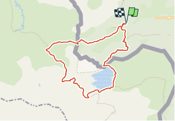
Ruta Senderismo de 10,2 km a descubrir en Nueva Aquitania, Pirineos-Atlánticos, Borce. Esta ruta ha sido propuesta por bedous.
Descripción
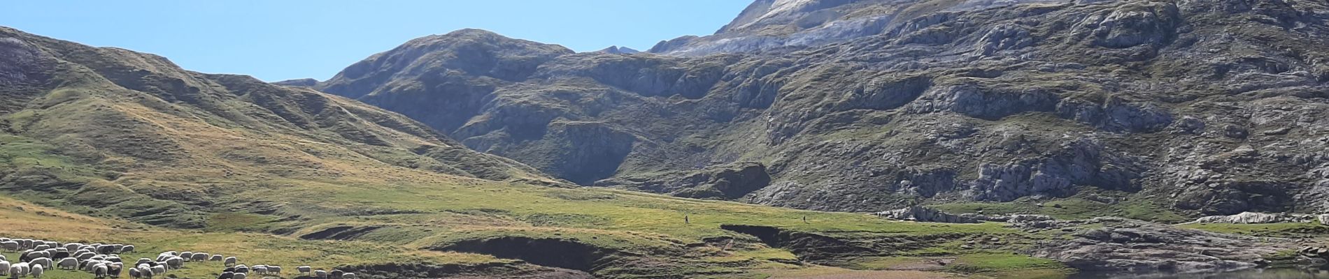
Magnifique randonnée avec dés le démarrage une belle cascade. En suivant le camino d'aguas tuertas nous sommes dans une prairie très humide en forme de vallée. un ruisseau se perd dans un gouffre. Le chemin emprunte très souvent le GR11.Les bords du lac sont fréquentés par des animaux: brebis, chevaux en saisons d'estives. Le lac est habité par un très grand nombre de truites. Le retour au départ du lac s'effectue par une échelle en fer d'une douzaine de barreaux.
Localización
Comentarios
Excursiones cerca
![Excursión A pie Urdos - Sentier de Peyranère au Refuge de Larry PNP - Photo](https://media.geolcdn.com/t/375/260/12d86d0c-9ae8-4a0a-b713-61ee3738bf3b.jpeg&format=jpg&maxdim=2)
![A pie A pie](https://static1.geolcdn.com/sitytour/trail-icons/100.png)
A pie
![](/images/other/stat-length.png)
![](https://static1.geolcdn.com/siteimages/upload/files/16400158638029165_repeat_loop_refresh_sync_direction_icon.png)
![Excursión A pie Urdos - Sentier du Plateau de la Gentiane PNP - Photo](https://media.geolcdn.com/t/375/260/12d86d0c-9ae8-4a0a-b713-61ee3738bf3b.jpeg&format=jpg&maxdim=2)
![A pie A pie](https://static1.geolcdn.com/sitytour/trail-icons/100.png)
A pie
![](/images/other/stat-length.png)
![](https://static1.geolcdn.com/siteimages/upload/files/16400158638029165_repeat_loop_refresh_sync_direction_icon.png)
![Excursión A pie Urdos - Sentier du Lac d'Estaëns PNP - Photo](https://media.geolcdn.com/t/375/260/f2b54571-15e4-4669-844e-6d4a7160a93e.jpeg&format=jpg&maxdim=2)
![A pie A pie](https://static1.geolcdn.com/sitytour/trail-icons/100.png)
A pie
![](/images/other/stat-length.png)
![](https://static1.geolcdn.com/siteimages/upload/files/16400158638029165_repeat_loop_refresh_sync_direction_icon.png)
![Excursión Senderismo Borce - Boucle Lescun 4J - E4 - Photo](https://media.geolcdn.com/t/375/260/ext.jpg?maxdim=2&url=https%3A%2F%2Fstatic1.geolcdn.com%2Fsiteimages%2Fupload%2Ffiles%2F1553511878bg_sport_marche.png)
![Senderismo Senderismo](https://static1.geolcdn.com/sitytour/trail-icons/101.png)
Senderismo
![](/images/other/stat-length.png)
![](https://static1.geolcdn.com/siteimages/upload/files/16400158638029165_repeat_loop_refresh_sync_direction_icon.png)
![Excursión Senderismo Borce - hrp Arlet to candanchu - Photo](https://media.geolcdn.com/t/375/260/ext.jpg?maxdim=2&url=https%3A%2F%2Fstatic1.geolcdn.com%2Fsiteimages%2Fupload%2Ffiles%2F1553511878bg_sport_marche.png)
![Senderismo Senderismo](https://static1.geolcdn.com/sitytour/trail-icons/101.png)
Senderismo
![](/images/other/stat-length.png)
![](https://static1.geolcdn.com/siteimages/upload/files/16400158638029165_repeat_loop_refresh_sync_direction_icon.png)
![Excursión Senderismo Borce - Chemin de l'escalé - Photo](https://media.geolcdn.com/t/375/260/a66f4049-6310-4965-a5bd-700ca57594e4.jpg&format=jpg&maxdim=2)
![Senderismo Senderismo](https://static1.geolcdn.com/sitytour/trail-icons/101.png)
Senderismo
![](/images/other/stat-length.png)
![](https://static1.geolcdn.com/siteimages/upload/files/16400158638029165_repeat_loop_refresh_sync_direction_icon.png)
![Excursión Senderismo Urdos - Plateau de la gentiane - Photo](https://media.geolcdn.com/t/375/260/b1985722-4b53-4d00-9ae9-e27a98bdc95b.jpg&format=jpg&maxdim=2)
![Senderismo Senderismo](https://static1.geolcdn.com/sitytour/trail-icons/101.png)
Senderismo
![](/images/other/stat-length.png)
![](https://static1.geolcdn.com/siteimages/upload/files/16400158638029165_repeat_loop_refresh_sync_direction_icon.png)
![Excursión Senderismo Urdos - Lac d'Estaens et environs - Photo](https://media.geolcdn.com/t/375/260/795b0e28-1fa9-4eb7-baf6-c4a84979127a.jpg&format=jpg&maxdim=2)
![Senderismo Senderismo](https://static1.geolcdn.com/sitytour/trail-icons/101.png)
Senderismo
![](/images/other/stat-length.png)
![](https://static1.geolcdn.com/siteimages/upload/files/16400158638029165_repeat_loop_refresh_sync_direction_icon.png)
![Excursión Senderismo Urdos - rando. en raquettes au col du Somport entre la vallée d'Aspe et l'Espagne - Photo](https://media.geolcdn.com/t/375/260/614d3cc2-bed2-4b64-8a0b-55dd858c11b5.jpg&format=jpg&maxdim=2)
![Senderismo Senderismo](https://static1.geolcdn.com/sitytour/trail-icons/101.png)
Senderismo
![](/images/other/stat-length.png)
![](https://static1.geolcdn.com/siteimages/upload/files/16400158638029165_repeat_loop_refresh_sync_direction_icon.png)