![](/images/other/stat-length.png)
![Excursión Senderismo Chenecey-Buillon - Gouffre des Granges-Mathieu. - Photo](https://media.geolcdn.com/t/1900/400/ext.pjpeg?maxdim=2&url=https%3A%2F%2Fstatic1.geolcdn.com%2Fsiteimages%2Fupload%2Ffiles%2F1553511878bg_sport_marche.png)
Gouffre des Granges-Mathieu.
RSVT Rando
Marchez curieux
![Longitud](/images/other/stat-length.png)
Longitud
10,1 km
![Altitud máxima](https://static1.geolcdn.com/siteimages/upload/files/1508320355ic_sort_altitude_max_24dp.png)
Altitud máxima
464 m
![Desnivel positivo](https://static1.geolcdn.com/siteimages/upload/files/1508320355ic_sort_den_pos_24dp.png)
Desnivel positivo
250 m
![Km-Effort](/images/other/stat-length.png)
Km-Effort
13,4 km
![Altitud mínima](https://static1.geolcdn.com/siteimages/upload/files/1508320355ic_sort_altitude_min_24dp.png)
Altitud mínima
343 m
![Desnivel negativo](https://static1.geolcdn.com/siteimages/upload/files/1508320355ic_sort_den_neg_24dp.png)
Desnivel negativo
250 m
![Boucle](https://static1.geolcdn.com/siteimages/upload/files/16400158638029165_repeat_loop_refresh_sync_direction_icon.png)
Boucle
Sí
Fecha de creación :
2023-09-23 13:43:16.0
Última modificación :
2023-10-31 17:17:09.512
![Senderismo](https://static1.geolcdn.com/sitytour/trail-icons/101.png)
3h02
Dificultad : Difícil
![Escanee este código QR para abrir la excursión en la aplicación SityTrail](https://capi.geolives.com/qq0zvz2zws4bq2lad0pu/sitytour/trails/3815599/qr.png?size=200)
Aplicación GPS de excursión GRATIS
A propósito
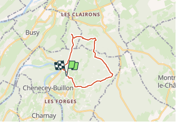
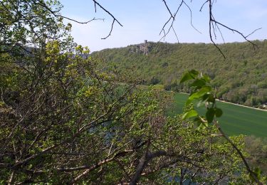
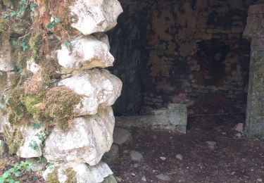
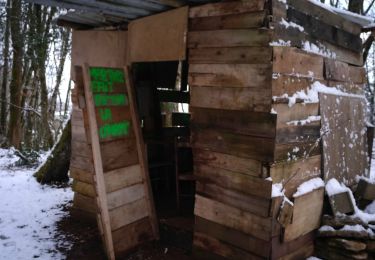
Ruta Senderismo de 10,1 km a descubrir en Borgoña-Franco Condado, Doubs, Chenecey-Buillon. Esta ruta ha sido propuesta por RSVT Rando.
Descripción
Le passage au chêne président est facultatif, je cherche toujours ce chêne, mais ne l'ai jamais trouvé!
Localización
País:
France
Región :
Borgoña-Franco Condado
Departamento/provincia :
Doubs
Municipio :
Chenecey-Buillon
Localidad:
Unknown
Salida:(Dec)
Salida:(UTM)
725296 ; 5225613 (31T) N.
Comentarios
Excursiones cerca
![Excursión A pie Busy - Sentier de la Pierre de Vorges - Photo](https://media.geolcdn.com/t/375/260/6f249824-322a-4d94-8931-19d5b1d90e88.jpeg&format=jpg&maxdim=2)
![A pie A pie](https://static1.geolcdn.com/sitytour/trail-icons/100.png)
Sentier de la Pierre de Vorges
A pie
Fácil
Busy,
Borgoña-Franco Condado,
Doubs,
France
![](/images/other/stat-length.png)
7,2 km | 9,4 km-effort
2h 8min
![](https://static1.geolcdn.com/siteimages/upload/files/16400158638029165_repeat_loop_refresh_sync_direction_icon.png)
Sí
![Excursión A pie Vorges-les-Pins - Sentier des Crêtes - Photo](https://media.geolcdn.com/t/375/260/11000138-aa02-48df-818f-23d3321a98ed.jpeg&format=jpg&maxdim=2)
![A pie A pie](https://static1.geolcdn.com/sitytour/trail-icons/100.png)
Sentier des Crêtes
A pie
Fácil
Vorges-les-Pins,
Borgoña-Franco Condado,
Doubs,
France
![](/images/other/stat-length.png)
4,2 km | 6,1 km-effort
1h 23min
![](https://static1.geolcdn.com/siteimages/upload/files/16400158638029165_repeat_loop_refresh_sync_direction_icon.png)
Sí
![Excursión A pie Montferrand-le-Château - Sentier de Crête et Bois Rapin - Photo](https://media.geolcdn.com/t/375/260/c8b25516-529e-4f5c-85cb-5313429ddb47.jpeg&format=jpg&maxdim=2)
![A pie A pie](https://static1.geolcdn.com/sitytour/trail-icons/100.png)
Sentier de Crête et Bois Rapin
A pie
Fácil
(1)
Montferrand-le-Château,
Borgoña-Franco Condado,
Doubs,
France
![](/images/other/stat-length.png)
10,1 km | 14,1 km-effort
3h 11min
![](https://static1.geolcdn.com/siteimages/upload/files/16400158638029165_repeat_loop_refresh_sync_direction_icon.png)
Sí
![Excursión Senderismo Pugey - pugey vierge comice arguel - Photo](https://media.geolcdn.com/t/375/260/210ae8a7-1f70-4f24-86c2-2d030290ac2e.jpg&format=jpg&maxdim=2)
![Senderismo Senderismo](https://static1.geolcdn.com/sitytour/trail-icons/101.png)
pugey vierge comice arguel
Senderismo
Medio
Pugey,
Borgoña-Franco Condado,
Doubs,
France
![](/images/other/stat-length.png)
15,9 km | 21 km-effort
3h 6min
![](https://static1.geolcdn.com/siteimages/upload/files/16400158638029165_repeat_loop_refresh_sync_direction_icon.png)
Sí
![Excursión A pie Larnod - Sentier découverte de Larnod - Photo](https://media.geolcdn.com/t/375/260/c8b25516-529e-4f5c-85cb-5313429ddb47.jpeg&format=jpg&maxdim=2)
![A pie A pie](https://static1.geolcdn.com/sitytour/trail-icons/100.png)
Sentier découverte de Larnod
A pie
Fácil
Larnod,
Borgoña-Franco Condado,
Doubs,
France
![](/images/other/stat-length.png)
5,8 km | 7,2 km-effort
1h 37min
![](https://static1.geolcdn.com/siteimages/upload/files/16400158638029165_repeat_loop_refresh_sync_direction_icon.png)
Sí
![Excursión Senderismo Busy - Busy Vierge du mont - Photo](https://media.geolcdn.com/t/375/260/a4594e72-5506-4551-90b2-490d3330d43d.jpg&format=jpg&maxdim=2)
![Senderismo Senderismo](https://static1.geolcdn.com/sitytour/trail-icons/101.png)
Busy Vierge du mont
Senderismo
Fácil
(1)
Busy,
Borgoña-Franco Condado,
Doubs,
France
![](/images/other/stat-length.png)
16,5 km | 23 km-effort
2h 57min
![](https://static1.geolcdn.com/siteimages/upload/files/16400158638029165_repeat_loop_refresh_sync_direction_icon.png)
Sí
![Excursión Senderismo Charnay - charnay - Photo](https://media.geolcdn.com/t/375/260/3a0b88c5-1d96-4f44-a545-03b03b7ef47c.jpg&format=jpg&maxdim=2)
![Senderismo Senderismo](https://static1.geolcdn.com/sitytour/trail-icons/101.png)
charnay
Senderismo
Muy fácil
Charnay,
Borgoña-Franco Condado,
Doubs,
France
![](/images/other/stat-length.png)
8,1 km | 11,7 km-effort
2h 29min
![](https://static1.geolcdn.com/siteimages/upload/files/16400158638029165_repeat_loop_refresh_sync_direction_icon.png)
Sí
![Excursión Senderismo Cessey - Cessey 2021-01-26 rando CAF - Photo](https://media.geolcdn.com/t/375/260/672450e4-6204-40da-8680-b68dabe30a24.jpg&format=jpg&maxdim=2)
![Senderismo Senderismo](https://static1.geolcdn.com/sitytour/trail-icons/101.png)
Cessey 2021-01-26 rando CAF
Senderismo
Difícil
Cessey,
Borgoña-Franco Condado,
Doubs,
France
![](/images/other/stat-length.png)
22 km | 31 km-effort
5h 0min
![](https://static1.geolcdn.com/siteimages/upload/files/16400158638029165_repeat_loop_refresh_sync_direction_icon.png)
Sí
![Excursión Senderismo Larnod - Larnod Beure Fontain 2024 - Photo](https://media.geolcdn.com/t/375/260/ext.jpg?maxdim=2&url=https%3A%2F%2Fstatic1.geolcdn.com%2Fsiteimages%2Fupload%2Ffiles%2F1553511878bg_sport_marche.png)
![Senderismo Senderismo](https://static1.geolcdn.com/sitytour/trail-icons/101.png)
Larnod Beure Fontain 2024
Senderismo
Difícil
Larnod,
Borgoña-Franco Condado,
Doubs,
France
![](/images/other/stat-length.png)
12,5 km | 18,3 km-effort
4h 9min
![](https://static1.geolcdn.com/siteimages/upload/files/16400158638029165_repeat_loop_refresh_sync_direction_icon.png)
Sí