![](/images/other/stat-length.png)
![Excursión Senderismo Ganzeville - Au coeur des 2 vallées - Photo](https://media.geolcdn.com/t/1900/400/ext.pjpeg?maxdim=2&url=https%3A%2F%2Fstatic1.geolcdn.com%2Fsiteimages%2Fupload%2Ffiles%2F1553511878bg_sport_marche.png)
Au coeur des 2 vallées
Jamyfredo
Usuario
![Longitud](/images/other/stat-length.png)
Longitud
11,2 km
![Altitud máxima](https://static1.geolcdn.com/siteimages/upload/files/1508320355ic_sort_altitude_max_24dp.png)
Altitud máxima
112 m
![Desnivel positivo](https://static1.geolcdn.com/siteimages/upload/files/1508320355ic_sort_den_pos_24dp.png)
Desnivel positivo
196 m
![Km-Effort](/images/other/stat-length.png)
Km-Effort
13,8 km
![Altitud mínima](https://static1.geolcdn.com/siteimages/upload/files/1508320355ic_sort_altitude_min_24dp.png)
Altitud mínima
11 m
![Desnivel negativo](https://static1.geolcdn.com/siteimages/upload/files/1508320355ic_sort_den_neg_24dp.png)
Desnivel negativo
197 m
![Boucle](https://static1.geolcdn.com/siteimages/upload/files/16400158638029165_repeat_loop_refresh_sync_direction_icon.png)
Boucle
Sí
Fecha de creación :
2023-09-18 16:16:07.366
Última modificación :
2023-09-18 16:19:05.305
![Senderismo](https://static1.geolcdn.com/sitytour/trail-icons/101.png)
2h25
Dificultad : Fácil
![Escanee este código QR para abrir la excursión en la aplicación SityTrail](https://capi.geolives.com/qq0zvz2zws4bq2lad0pu/sitytour/trails/3810856/qr.png?size=200)
Aplicación GPS de excursión GRATIS
A propósito
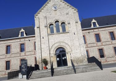
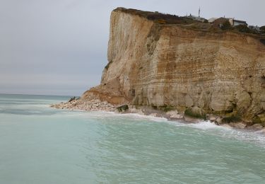
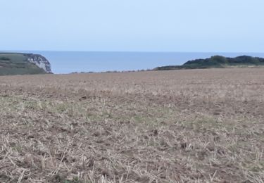
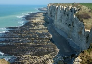
Ruta Senderismo de 11,2 km a descubrir en Normandía, Sena-Marítimo, Ganzeville. Esta ruta ha sido propuesta por Jamyfredo.
Descripción
Diversités de paysages et d'atmosphères qu'offrent les proches alentours de Fécamp en passant dans la vallée de Ganzeville et de Valmont
Localización
País:
France
Región :
Normandía
Departamento/provincia :
Sena-Marítimo
Municipio :
Ganzeville
Localidad:
Unknown
Salida:(Dec)
Salida:(UTM)
313494 ; 5512203 (31U) N.
Comentarios
Excursiones cerca
![Excursión Senderismo Fécamp - Nid Verdier - Val aux lièvres - Photo](https://media.geolcdn.com/t/375/260/ext.jpg?maxdim=2&url=https%3A%2F%2Fstatic1.geolcdn.com%2Fsiteimages%2Fupload%2Ffiles%2F1553511878bg_sport_marche.png)
![Senderismo Senderismo](https://static1.geolcdn.com/sitytour/trail-icons/101.png)
Nid Verdier - Val aux lièvres
Senderismo
Medio
(1)
Fécamp,
Normandía,
Sena-Marítimo,
France
![](/images/other/stat-length.png)
6,3 km | 7,8 km-effort
1h 42min
![](https://static1.geolcdn.com/siteimages/upload/files/16400158638029165_repeat_loop_refresh_sync_direction_icon.png)
Sí
![Excursión Senderismo Fécamp - fecamp - Photo](https://media.geolcdn.com/t/375/260/d0e6349d-5429-4f08-9deb-c4d6ba33fa26.jpg&format=jpg&maxdim=2)
![Senderismo Senderismo](https://static1.geolcdn.com/sitytour/trail-icons/101.png)
fecamp
Senderismo
Medio
Fécamp,
Normandía,
Sena-Marítimo,
France
![](/images/other/stat-length.png)
10,5 km | 12,9 km-effort
3h 4min
![](https://static1.geolcdn.com/siteimages/upload/files/16400158638029165_repeat_loop_refresh_sync_direction_icon.png)
Sí
![Excursión Senderismo Fécamp - la capelle a Fécamp - Photo](https://media.geolcdn.com/t/375/260/1b7b4132-ad2b-4597-be7b-ed63911e98b5.jpg&format=jpg&maxdim=2)
![Senderismo Senderismo](https://static1.geolcdn.com/sitytour/trail-icons/101.png)
la capelle a Fécamp
Senderismo
Fácil
Fécamp,
Normandía,
Sena-Marítimo,
France
![](/images/other/stat-length.png)
8,5 km | 10,6 km-effort
1h 57min
![](https://static1.geolcdn.com/siteimages/upload/files/16400158638029165_repeat_loop_refresh_sync_direction_icon.png)
No
![Excursión Otra actividad Saint-Léonard - grainval -yport puis tour dans yport vers casino - Photo](https://media.geolcdn.com/t/375/260/ext.jpg?maxdim=2&url=https%3A%2F%2Fservices.sitytrail.com%2FGeolivesWS%2FDownloadMedia.ashx%3FTrailID%3D1028875%26Media%3Dfix__20180826113810.jpg)
![Otra actividad Otra actividad](https://static1.geolcdn.com/sitytour/trail-icons/900.png)
grainval -yport puis tour dans yport vers casino
Otra actividad
Muy fácil
Saint-Léonard,
Normandía,
Sena-Marítimo,
France
![](/images/other/stat-length.png)
5,2 km | 6,8 km-effort
49min
![](https://static1.geolcdn.com/siteimages/upload/files/16400158638029165_repeat_loop_refresh_sync_direction_icon.png)
No
![Excursión Motor Fécamp - Fécamp-Rouen 15.10.17 - Photo](https://media.geolcdn.com/t/375/260/ext.jpg?maxdim=2&url=https%3A%2F%2Fservices.sitytrail.com%2FGeolivesWS%2FDownloadMedia.ashx%3FTrailID%3D849051%26Media%3Dfix__20171015182604.jpg)
![Motor Motor](https://static1.geolcdn.com/sitytour/trail-icons/400.png)
Fécamp-Rouen 15.10.17
Motor
Muy fácil
Fécamp,
Normandía,
Sena-Marítimo,
France
![](/images/other/stat-length.png)
205 km | 234 km-effort
7h 4min
![](https://static1.geolcdn.com/siteimages/upload/files/16400158638029165_repeat_loop_refresh_sync_direction_icon.png)
No
![Excursión Senderismo Fécamp - Étretat jour 2 - Photo](https://media.geolcdn.com/t/375/260/ext.jpg?maxdim=2&url=https%3A%2F%2Fservices.sitytrail.com%2FGeolivesWS%2FDownloadMedia.ashx%3FTrailID%3D721389%26Media%3Dfix__20170326152128.jpg)
![Senderismo Senderismo](https://static1.geolcdn.com/sitytour/trail-icons/101.png)
Étretat jour 2
Senderismo
Muy fácil
Fécamp,
Normandía,
Sena-Marítimo,
France
![](/images/other/stat-length.png)
17,6 km | 23 km-effort
7h 51min
![](https://static1.geolcdn.com/siteimages/upload/files/16400158638029165_repeat_loop_refresh_sync_direction_icon.png)
No
![Excursión Senderismo Fécamp - Cirkwi-La-cote-de-la-Vierge---Circuit-n-12 - Photo](https://media.geolcdn.com/t/375/260/ext.jpg?maxdim=2&url=https%3A%2F%2Fstatic1.geolcdn.com%2Fsiteimages%2Fupload%2Ffiles%2F1553511878bg_sport_marche.png)
![Senderismo Senderismo](https://static1.geolcdn.com/sitytour/trail-icons/101.png)
Cirkwi-La-cote-de-la-Vierge---Circuit-n-12
Senderismo
Difícil
(1)
Fécamp,
Normandía,
Sena-Marítimo,
France
![](/images/other/stat-length.png)
12,9 km | 15,2 km-effort
3h 27min
![](https://static1.geolcdn.com/siteimages/upload/files/16400158638029165_repeat_loop_refresh_sync_direction_icon.png)
Sí
![Excursión Senderismo Saint-Léonard - Cirkwi-Sur-les-pas-des-ramendeuses---Circuit-n-16 - Photo](https://media.geolcdn.com/t/375/260/ext.jpg?maxdim=2&url=https%3A%2F%2Fstatic1.geolcdn.com%2Fsiteimages%2Fupload%2Ffiles%2F1553511878bg_sport_marche.png)
![Senderismo Senderismo](https://static1.geolcdn.com/sitytour/trail-icons/101.png)
Cirkwi-Sur-les-pas-des-ramendeuses---Circuit-n-16
Senderismo
Difícil
Saint-Léonard,
Normandía,
Sena-Marítimo,
France
![](/images/other/stat-length.png)
13,6 km | 17,2 km-effort
3h 53min
![](https://static1.geolcdn.com/siteimages/upload/files/16400158638029165_repeat_loop_refresh_sync_direction_icon.png)
Sí
![Excursión Senderismo Bec-de-Mortagne - bec de mortagne - Photo](https://media.geolcdn.com/t/375/260/ext.jpg?maxdim=2&url=https%3A%2F%2Fstatic1.geolcdn.com%2Fsiteimages%2Fupload%2Ffiles%2F1553511878bg_sport_marche.png)
![Senderismo Senderismo](https://static1.geolcdn.com/sitytour/trail-icons/101.png)
bec de mortagne
Senderismo
Medio
Bec-de-Mortagne,
Normandía,
Sena-Marítimo,
France
![](/images/other/stat-length.png)
12,7 km | 14,8 km-effort
2h 52min
![](https://static1.geolcdn.com/siteimages/upload/files/16400158638029165_repeat_loop_refresh_sync_direction_icon.png)
Sí