![](/images/other/stat-length.png)
![Excursión Senderismo Chabanière - 69_st_maurice_dargeoire_12km_300m - Photo](https://media.geolcdn.com/t/1900/400/83f5b7e0-e7a1-44e9-9c6c-d04e1b215358.jpg&format=pjpeg&maxdim=2)
69_st_maurice_dargeoire_12km_300m
SyMA
Usuario
![Longitud](/images/other/stat-length.png)
Longitud
11,6 km
![Altitud máxima](https://static1.geolcdn.com/siteimages/upload/files/1508320355ic_sort_altitude_max_24dp.png)
Altitud máxima
615 m
![Desnivel positivo](https://static1.geolcdn.com/siteimages/upload/files/1508320355ic_sort_den_pos_24dp.png)
Desnivel positivo
296 m
![Km-Effort](/images/other/stat-length.png)
Km-Effort
15,5 km
![Altitud mínima](https://static1.geolcdn.com/siteimages/upload/files/1508320355ic_sort_altitude_min_24dp.png)
Altitud mínima
389 m
![Desnivel negativo](https://static1.geolcdn.com/siteimages/upload/files/1508320355ic_sort_den_neg_24dp.png)
Desnivel negativo
297 m
![Boucle](https://static1.geolcdn.com/siteimages/upload/files/16400158638029165_repeat_loop_refresh_sync_direction_icon.png)
Boucle
Sí
Fecha de creación :
2023-09-12 06:14:05.541
Última modificación :
2023-09-12 14:02:15.467
![Senderismo](https://static1.geolcdn.com/sitytour/trail-icons/101.png)
3h31
Dificultad : Medio
![Escanee este código QR para abrir la excursión en la aplicación SityTrail](https://capi.geolives.com/qq0zvz2zws4bq2lad0pu/sitytour/trails/3803749/qr.png?size=200)
Aplicación GPS de excursión GRATIS
A propósito
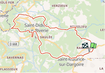
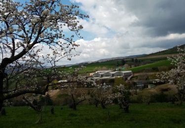
Ruta Senderismo de 11,6 km a descubrir en Auvergne-Rhône-Alpes, Ródano, Chabanière. Esta ruta ha sido propuesta por SyMA.
Descripción
Départ parking prés de terrain de sport
boucle par St Didier sous Riverie
terrain facile mais peu d'ombre sur cette partie
Localización
País:
France
Región :
Auvergne-Rhône-Alpes
Departamento/provincia :
Ródano
Municipio :
Chabanière
Localidad:
Saint-Maurice-sur-Dargoire
Salida:(Dec)
Salida:(UTM)
627940 ; 5049330 (31T) N.
Comentarios
Excursiones cerca
![Excursión Senderismo Mornant - Mornant-Lac de la Madone à St Sorlin - Photo](https://media.geolcdn.com/t/375/260/a7fe3626-6640-4450-bfe5-8d72b58566d1.jpg&format=jpg&maxdim=2)
![Senderismo Senderismo](https://static1.geolcdn.com/sitytour/trail-icons/101.png)
Mornant-Lac de la Madone à St Sorlin
Senderismo
Medio
(1)
Mornant,
Auvergne-Rhône-Alpes,
Ródano,
France
![](/images/other/stat-length.png)
7,3 km | 9,5 km-effort
1h 28min
![](https://static1.geolcdn.com/siteimages/upload/files/16400158638029165_repeat_loop_refresh_sync_direction_icon.png)
Sí
![Excursión Senderismo Trèves - Chemin de Fer à Trèves - Photo](https://media.geolcdn.com/t/375/260/ext.jpg?maxdim=2&url=https%3A%2F%2Fservices.sitytrail.com%2FGeolivesWS%2FDownloadMedia.ashx%3FTrailID%3D107163%26Media%3D12007_3.jpg)
![Senderismo Senderismo](https://static1.geolcdn.com/sitytour/trail-icons/101.png)
Chemin de Fer à Trèves
Senderismo
Medio
(1)
Trèves,
Auvergne-Rhône-Alpes,
Ródano,
France
![](/images/other/stat-length.png)
4,5 km | 6,8 km-effort
1h 30min
![](https://static1.geolcdn.com/siteimages/upload/files/16400158638029165_repeat_loop_refresh_sync_direction_icon.png)
Sí
![Excursión Senderismo Saint-Joseph - 42-st-joseph-10km-320m - Photo](https://media.geolcdn.com/t/375/260/d6018596-5a38-4194-9525-041abab6ce05.jpg&format=jpg&maxdim=2)
![Senderismo Senderismo](https://static1.geolcdn.com/sitytour/trail-icons/101.png)
42-st-joseph-10km-320m
Senderismo
Fácil
Saint-Joseph,
Auvergne-Rhône-Alpes,
Loira,
France
![](/images/other/stat-length.png)
10,5 km | 14,8 km-effort
2h 50min
![](https://static1.geolcdn.com/siteimages/upload/files/16400158638029165_repeat_loop_refresh_sync_direction_icon.png)
Sí
![Excursión Senderismo Chabanière - 69-st-maurice-dargoire2-19km-580m - Photo](https://media.geolcdn.com/t/375/260/c4b20fd4-ad58-4836-9971-2020b70efe6f.jpg&format=jpg&maxdim=2)
![Senderismo Senderismo](https://static1.geolcdn.com/sitytour/trail-icons/101.png)
69-st-maurice-dargoire2-19km-580m
Senderismo
Difícil
Chabanière,
Auvergne-Rhône-Alpes,
Ródano,
France
![](/images/other/stat-length.png)
19,2 km | 27 km-effort
5h 47min
![](https://static1.geolcdn.com/siteimages/upload/files/16400158638029165_repeat_loop_refresh_sync_direction_icon.png)
Sí
![Excursión Senderismo Saint-Martin-la-Plaine - 42-martinlaplaine-12km450m - Photo](https://media.geolcdn.com/t/375/260/0bbcbe3d-ff1f-4c48-95ef-874625509cfa.jpg&format=jpg&maxdim=2)
![Senderismo Senderismo](https://static1.geolcdn.com/sitytour/trail-icons/101.png)
42-martinlaplaine-12km450m
Senderismo
Difícil
Saint-Martin-la-Plaine,
Auvergne-Rhône-Alpes,
Loira,
France
![](/images/other/stat-length.png)
12,9 km | 18,9 km-effort
4h 17min
![](https://static1.geolcdn.com/siteimages/upload/files/16400158638029165_repeat_loop_refresh_sync_direction_icon.png)
Sí
![Excursión Senderismo Riverie - Riverie - Tour au dessus de Riverie - Photo](https://media.geolcdn.com/t/375/260/f386fa9b-109a-4f00-b8bc-6419b37fffdc.jpg&format=jpg&maxdim=2)
![Senderismo Senderismo](https://static1.geolcdn.com/sitytour/trail-icons/101.png)
Riverie - Tour au dessus de Riverie
Senderismo
Medio
Riverie,
Auvergne-Rhône-Alpes,
Ródano,
France
![](/images/other/stat-length.png)
5,7 km | 7,8 km-effort
2h 4min
![](https://static1.geolcdn.com/siteimages/upload/files/16400158638029165_repeat_loop_refresh_sync_direction_icon.png)
Sí
![Excursión Senderismo Saint-André-la-Côte - 69-st-andre-la cote-mattiole-20km-640m-mai22 - Photo](https://media.geolcdn.com/t/375/260/7a464e9e-07ad-49d2-9fc0-eab7bce1d3e5.jpg&format=jpg&maxdim=2)
![Senderismo Senderismo](https://static1.geolcdn.com/sitytour/trail-icons/101.png)
69-st-andre-la cote-mattiole-20km-640m-mai22
Senderismo
Medio
Saint-André-la-Côte,
Auvergne-Rhône-Alpes,
Ródano,
France
![](/images/other/stat-length.png)
20 km | 29 km-effort
5h 56min
![](https://static1.geolcdn.com/siteimages/upload/files/16400158638029165_repeat_loop_refresh_sync_direction_icon.png)
Sí
![Excursión Senderismo Saint-Martin-la-Plaine - rando autour de St Martin la plaine, - Photo](https://media.geolcdn.com/t/375/260/edbc12e4-5772-4b73-9ba2-a3d81bfb5c32.jpg&format=jpg&maxdim=2)
![Senderismo Senderismo](https://static1.geolcdn.com/sitytour/trail-icons/101.png)
rando autour de St Martin la plaine,
Senderismo
Fácil
Saint-Martin-la-Plaine,
Auvergne-Rhône-Alpes,
Loira,
France
![](/images/other/stat-length.png)
10,4 km | 13,6 km-effort
3h 6min
![](https://static1.geolcdn.com/siteimages/upload/files/16400158638029165_repeat_loop_refresh_sync_direction_icon.png)
Sí
![Excursión Senderismo Saint-André-la-Côte - 69-St-andre-la-cote-Ste-catherine-14km-453m - Photo](https://media.geolcdn.com/t/375/260/06cb0992-8e16-4e77-b851-837722622855.jpg&format=jpg&maxdim=2)
![Senderismo Senderismo](https://static1.geolcdn.com/sitytour/trail-icons/101.png)
69-St-andre-la-cote-Ste-catherine-14km-453m
Senderismo
Medio
Saint-André-la-Côte,
Auvergne-Rhône-Alpes,
Ródano,
France
![](/images/other/stat-length.png)
14,2 km | 20 km-effort
3h 48min
![](https://static1.geolcdn.com/siteimages/upload/files/16400158638029165_repeat_loop_refresh_sync_direction_icon.png)
Sí