![](/images/other/stat-length.png)
![Excursión Senderismo Saint-Hubert - ADEPS BASKET SAINT-HUBERT23 - Photo](https://media.geolcdn.com/t/1900/400/ext.pjpeg?maxdim=2&url=https%3A%2F%2Fstatic1.geolcdn.com%2Fsiteimages%2Fupload%2Ffiles%2F1553511878bg_sport_marche.png)
ADEPS BASKET SAINT-HUBERT23
Freddy Cheter
Usuario
![Longitud](/images/other/stat-length.png)
Longitud
18,2 km
![Altitud máxima](https://static1.geolcdn.com/siteimages/upload/files/1508320355ic_sort_altitude_max_24dp.png)
Altitud máxima
582 m
![Desnivel positivo](https://static1.geolcdn.com/siteimages/upload/files/1508320355ic_sort_den_pos_24dp.png)
Desnivel positivo
368 m
![Km-Effort](/images/other/stat-length.png)
Km-Effort
23 km
![Altitud mínima](https://static1.geolcdn.com/siteimages/upload/files/1508320355ic_sort_altitude_min_24dp.png)
Altitud mínima
362 m
![Desnivel negativo](https://static1.geolcdn.com/siteimages/upload/files/1508320355ic_sort_den_neg_24dp.png)
Desnivel negativo
369 m
![Boucle](https://static1.geolcdn.com/siteimages/upload/files/16400158638029165_repeat_loop_refresh_sync_direction_icon.png)
Boucle
Sí
Fecha de creación :
2023-09-10 04:59:09.623
Última modificación :
2023-09-10 08:08:46.074
![Senderismo](https://static1.geolcdn.com/sitytour/trail-icons/101.png)
3h09
Dificultad : Muy difícil
![Escanee este código QR para abrir la excursión en la aplicación SityTrail](https://capi.geolives.com/qq0zvz2zws4bq2lad0pu/sitytour/trails/3801437/qr.png?size=200)
Aplicación GPS de excursión GRATIS
A propósito
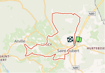
Ruta Senderismo de 18,2 km a descubrir en Valonia, Luxemburgo, Saint-Hubert. Esta ruta ha sido propuesta por Freddy Cheter.
Descripción
déception 4km de forêt, marche à travers champs, villages (Lorcy,Arville) plus de 10km de route en béton ou tarmac
Localización
País:
Belgium
Región :
Valonia
Departamento/provincia :
Luxemburgo
Municipio :
Saint-Hubert
Localidad:
Unknown
Salida:(Dec)
Salida:(UTM)
670583 ; 5544546 (31U) N.
Comentarios
Excursiones cerca
![Excursión Senderismo Saint-Hubert - Saint-Hubert - La Borne (SH07) - Photo](https://media.geolcdn.com/t/375/260/ext.jpg?maxdim=2&url=https%3A%2F%2Fservices.sitytrail.com%2FGeolivesWS%2FDownloadMedia.ashx%3FTrailID%3D334588%26Media%3D91d6a6a6-ea9a-437b-8504-44eab9898f8f.JPG)
![Senderismo Senderismo](https://static1.geolcdn.com/sitytour/trail-icons/101.png)
Saint-Hubert - La Borne (SH07)
Senderismo
Difícil
(9)
Saint-Hubert,
Valonia,
Luxemburgo,
Belgium
![](/images/other/stat-length.png)
13,9 km | 17,6 km-effort
3h 47min
![](https://static1.geolcdn.com/siteimages/upload/files/16400158638029165_repeat_loop_refresh_sync_direction_icon.png)
Sí
![Excursión Senderismo Saint-Hubert - Hatrival - Banalbois (SH13) - Photo](https://media.geolcdn.com/t/375/260/ext.jpg?maxdim=2&url=https%3A%2F%2Fservices.sitytrail.com%2FGeolivesWS%2FDownloadMedia.ashx%3FTrailID%3D334467%26Media%3D16828998-416a-43a0-960f-95ce479e5d6d.jpg)
![Senderismo Senderismo](https://static1.geolcdn.com/sitytour/trail-icons/101.png)
Hatrival - Banalbois (SH13)
Senderismo
Medio
(6)
Saint-Hubert,
Valonia,
Luxemburgo,
Belgium
![](/images/other/stat-length.png)
7,5 km | 9,5 km-effort
2h 2min
![](https://static1.geolcdn.com/siteimages/upload/files/16400158638029165_repeat_loop_refresh_sync_direction_icon.png)
Sí
![Senderismo Senderismo](https://static1.geolcdn.com/sitytour/trail-icons/101.png)
RB-Lu-26_Saint-Hubert_via-racc-1-et-2
Senderismo
Muy fácil
(8)
Saint-Hubert,
Valonia,
Luxemburgo,
Belgium
![](/images/other/stat-length.png)
14,6 km | 19,5 km-effort
4h 15min
![](https://static1.geolcdn.com/siteimages/upload/files/16400158638029165_repeat_loop_refresh_sync_direction_icon.png)
Sí
![Excursión Senderismo Saint-Hubert - Vesqueville - Vesqueville (SH09) - Photo](https://media.geolcdn.com/t/375/260/ext.jpg?maxdim=2&url=https%3A%2F%2Fservices.sitytrail.com%2FGeolivesWS%2FDownloadMedia.ashx%3FTrailID%3D334610%26Media%3D79c980a9-bd48-4f1e-9150-6b805f1400ff.jpg)
![Senderismo Senderismo](https://static1.geolcdn.com/sitytour/trail-icons/101.png)
Vesqueville - Vesqueville (SH09)
Senderismo
Difícil
(6)
Saint-Hubert,
Valonia,
Luxemburgo,
Belgium
![](/images/other/stat-length.png)
15,6 km | 19,4 km-effort
4h 9min
![](https://static1.geolcdn.com/siteimages/upload/files/16400158638029165_repeat_loop_refresh_sync_direction_icon.png)
Sí
![Excursión Senderismo Saint-Hubert - Saint-Hubert - Les Abanages (SH03) - Photo](https://media.geolcdn.com/t/375/260/ext.jpg?maxdim=2&url=https%3A%2F%2Fservices.sitytrail.com%2FGeolivesWS%2FDownloadMedia.ashx%3FTrailID%3D334550%26Media%3D8af2823f-59d0-452e-b66b-4a477ca4facd.JPG)
![Senderismo Senderismo](https://static1.geolcdn.com/sitytour/trail-icons/101.png)
Saint-Hubert - Les Abanages (SH03)
Senderismo
Difícil
(13)
Saint-Hubert,
Valonia,
Luxemburgo,
Belgium
![](/images/other/stat-length.png)
9,8 km | 13,1 km-effort
2h 49min
![](https://static1.geolcdn.com/siteimages/upload/files/16400158638029165_repeat_loop_refresh_sync_direction_icon.png)
Sí
![Excursión Senderismo Saint-Hubert - Saint-Hubert - Les Gottes (SH02) - Photo](https://media.geolcdn.com/t/375/260/ext.jpg?maxdim=2&url=https%3A%2F%2Fservices.sitytrail.com%2FGeolivesWS%2FDownloadMedia.ashx%3FTrailID%3D334532%26Media%3D483dd5de-c3cc-4d3d-acb4-87fceee0aac0.JPG)
![Senderismo Senderismo](https://static1.geolcdn.com/sitytour/trail-icons/101.png)
Saint-Hubert - Les Gottes (SH02)
Senderismo
Medio
(17)
Saint-Hubert,
Valonia,
Luxemburgo,
Belgium
![](/images/other/stat-length.png)
6,9 km | 8,6 km-effort
1h 52min
![](https://static1.geolcdn.com/siteimages/upload/files/16400158638029165_repeat_loop_refresh_sync_direction_icon.png)
Sí
![Excursión Senderismo Saint-Hubert - Marche ADEPS Arville - Photo](https://media.geolcdn.com/t/375/260/3bbd3001-2495-4fe0-a9c1-b38774f0038e.jpg&format=jpg&maxdim=2)
![Senderismo Senderismo](https://static1.geolcdn.com/sitytour/trail-icons/101.png)
Marche ADEPS Arville
Senderismo
Medio
(1)
Saint-Hubert,
Valonia,
Luxemburgo,
Belgium
![](/images/other/stat-length.png)
10,2 km | 13,6 km-effort
2h 13min
![](https://static1.geolcdn.com/siteimages/upload/files/16400158638029165_repeat_loop_refresh_sync_direction_icon.png)
Sí
![Excursión Senderismo Saint-Hubert - ADEPS Saint Hubert - Photo](https://media.geolcdn.com/t/375/260/018b420c-08b1-4fdb-919c-55acbcd603df.jpg&format=jpg&maxdim=2)
![Senderismo Senderismo](https://static1.geolcdn.com/sitytour/trail-icons/101.png)
ADEPS Saint Hubert
Senderismo
Difícil
(1)
Saint-Hubert,
Valonia,
Luxemburgo,
Belgium
![](/images/other/stat-length.png)
10,8 km | 13,7 km-effort
1h 57min
![](https://static1.geolcdn.com/siteimages/upload/files/16400158638029165_repeat_loop_refresh_sync_direction_icon.png)
Sí
![Senderismo Senderismo](https://static1.geolcdn.com/sitytour/trail-icons/101.png)
RB-Lu-26_Saint-Hubert
Senderismo
Muy fácil
(7)
Saint-Hubert,
Valonia,
Luxemburgo,
Belgium
![](/images/other/stat-length.png)
25 km | 33 km-effort
7h 2min
![](https://static1.geolcdn.com/siteimages/upload/files/16400158638029165_repeat_loop_refresh_sync_direction_icon.png)
Sí