![](/images/other/stat-length.png)
![Excursión Senderismo Canteleu - Roumare-PT-7,6KM - Photo](https://media.geolcdn.com/t/1900/400/ext.pjpeg?maxdim=2&url=https%3A%2F%2Fstatic1.geolcdn.com%2Fsiteimages%2Fupload%2Ffiles%2F1553511878bg_sport_marche.png)
Roumare-PT-7,6KM
philippe76
Usuario
![Longitud](/images/other/stat-length.png)
![Altitud máxima](https://static1.geolcdn.com/siteimages/upload/files/1508320355ic_sort_altitude_max_24dp.png)
![Desnivel positivo](https://static1.geolcdn.com/siteimages/upload/files/1508320355ic_sort_den_pos_24dp.png)
![Km-Effort](/images/other/stat-length.png)
![Altitud mínima](https://static1.geolcdn.com/siteimages/upload/files/1508320355ic_sort_altitude_min_24dp.png)
![Desnivel negativo](https://static1.geolcdn.com/siteimages/upload/files/1508320355ic_sort_den_neg_24dp.png)
![Boucle](https://static1.geolcdn.com/siteimages/upload/files/16400158638029165_repeat_loop_refresh_sync_direction_icon.png)
![Senderismo](https://static1.geolcdn.com/sitytour/trail-icons/101.png)
1h53
Dificultad : Fácil
![Escanee este código QR para abrir la excursión en la aplicación SityTrail](https://capi.geolives.com/qq0zvz2zws4bq2lad0pu/sitytour/trails/380076/qr.png?size=200)
Aplicación GPS de excursión GRATIS
A propósito
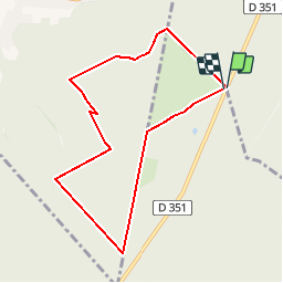
Ruta Senderismo de 7,5 km a descubrir en Normandía, Sena-Marítimo, Canteleu. Esta ruta ha sido propuesta por philippe76.
Descripción
Départ du parking de la maison Ftière du Hêtre des gardes.
Prendre la rte Ftière de la Réunion. AG rte Ftière du Chevreuil, AG prendre le PR, et AG. Alt 114 AG vers Mare Auzou, Alt 111 AD, AG vers Maison Ftière de la mare Grand Camp. AD Rte Ftière ST Pierre, AG Rte Ftière de la Borne jusqu`à rte Ftière du petit Charme et prendre AG. Au carrefour du Petit Charme AD Rte Ftière St Pierre jusqu'au Parking.
Localización
Comentarios
Excursiones cerca
![Excursión Senderismo Petit-Couronne - Petit-couronne. Vers le puis Hébert 10 Km - Photo](https://media.geolcdn.com/t/375/260/9dd7ff8d-d608-41d9-8051-e1aced3a0a8b.jpg&format=jpg&maxdim=2)
![Senderismo Senderismo](https://static1.geolcdn.com/sitytour/trail-icons/101.png)
Senderismo
![](/images/other/stat-length.png)
![](https://static1.geolcdn.com/siteimages/upload/files/16400158638029165_repeat_loop_refresh_sync_direction_icon.png)
![Excursión Senderismo Saint-Martin-de-Boscherville - Les Marais - St Martin de Boscherville - Photo](https://media.geolcdn.com/t/375/260/ext.jpg?maxdim=2&url=https%3A%2F%2Fservices.sitytrail.com%2FGeolivesWS%2FDownloadMedia.ashx%3FTrailID%3D105880%26Media%3D9864_1.jpg)
![Senderismo Senderismo](https://static1.geolcdn.com/sitytour/trail-icons/101.png)
Senderismo
![](/images/other/stat-length.png)
![](https://static1.geolcdn.com/siteimages/upload/files/16400158638029165_repeat_loop_refresh_sync_direction_icon.png)
![Excursión Senderismo Canteleu - Canteleu - Montigny - GD - Photo](https://media.geolcdn.com/t/375/260/ext.jpg?maxdim=2&url=https%3A%2F%2Fstatic1.geolcdn.com%2Fsiteimages%2Fupload%2Ffiles%2F1553511878bg_sport_marche.png)
![Senderismo Senderismo](https://static1.geolcdn.com/sitytour/trail-icons/101.png)
Senderismo
![](/images/other/stat-length.png)
![](https://static1.geolcdn.com/siteimages/upload/files/16400158638029165_repeat_loop_refresh_sync_direction_icon.png)
![Excursión A pie Saint-Pierre-de-Manneville - Du coté du Manoir de Villers - Photo](https://media.geolcdn.com/t/375/260/ext.jpg?maxdim=2&url=https%3A%2F%2Fstatic1.geolcdn.com%2Fsiteimages%2Fupload%2Ffiles%2F1545311037marcheuse_200dpi.jpg)
![A pie A pie](https://static1.geolcdn.com/sitytour/trail-icons/100.png)
A pie
![](/images/other/stat-length.png)
![](https://static1.geolcdn.com/siteimages/upload/files/16400158638029165_repeat_loop_refresh_sync_direction_icon.png)
![Excursión Senderismo Petit-Couronne - Petit-Couronne Rando 9km200 - Photo](https://media.geolcdn.com/t/375/260/ext.jpg?maxdim=2&url=https%3A%2F%2Fstatic1.geolcdn.com%2Fsiteimages%2Fupload%2Ffiles%2F1553511878bg_sport_marche.png)
![Senderismo Senderismo](https://static1.geolcdn.com/sitytour/trail-icons/101.png)
Senderismo
![](/images/other/stat-length.png)
![](https://static1.geolcdn.com/siteimages/upload/files/16400158638029165_repeat_loop_refresh_sync_direction_icon.png)
![Excursión Senderismo Saint-Étienne-du-Rouvray - Forêt St. EtienneDu Rouvray P2 (86) - Photo](https://media.geolcdn.com/t/375/260/ext.jpg?maxdim=2&url=https%3A%2F%2Fstatic1.geolcdn.com%2Fsiteimages%2Fupload%2Ffiles%2F1553511878bg_sport_marche.png)
![Senderismo Senderismo](https://static1.geolcdn.com/sitytour/trail-icons/101.png)
Senderismo
![](/images/other/stat-length.png)
![](https://static1.geolcdn.com/siteimages/upload/files/16400158638029165_repeat_loop_refresh_sync_direction_icon.png)
![Excursión Senderismo Canteleu - canteleu parc animalier - Photo](https://media.geolcdn.com/t/375/260/ext.jpg?maxdim=2&url=https%3A%2F%2Fstatic1.geolcdn.com%2Fsiteimages%2Fupload%2Ffiles%2F1553511878bg_sport_marche.png)
![Senderismo Senderismo](https://static1.geolcdn.com/sitytour/trail-icons/101.png)
Senderismo
![](/images/other/stat-length.png)
![](https://static1.geolcdn.com/siteimages/upload/files/16400158638029165_repeat_loop_refresh_sync_direction_icon.png)
![Excursión Senderismo Bardouville - bardouville - Photo](https://media.geolcdn.com/t/375/260/ext.jpg?maxdim=2&url=https%3A%2F%2Fstatic1.geolcdn.com%2Fsiteimages%2Fupload%2Ffiles%2F1553511878bg_sport_marche.png)
![Senderismo Senderismo](https://static1.geolcdn.com/sitytour/trail-icons/101.png)
Senderismo
![](/images/other/stat-length.png)
![](https://static1.geolcdn.com/siteimages/upload/files/16400158638029165_repeat_loop_refresh_sync_direction_icon.png)
![Excursión Bici de montaña Canteleu - Randonnée VTT Oxibike 2011 Canteleu 40 Kms - Photo](https://media.geolcdn.com/t/375/260/ext.jpg?maxdim=2&url=https%3A%2F%2Fstatic1.geolcdn.com%2Fsiteimages%2Fupload%2Ffiles%2F1524743154velo.jpg)
![Bici de montaña Bici de montaña](https://static1.geolcdn.com/sitytour/trail-icons/202.png)
Bici de montaña
![](/images/other/stat-length.png)
![](https://static1.geolcdn.com/siteimages/upload/files/16400158638029165_repeat_loop_refresh_sync_direction_icon.png)