![](/images/other/stat-length.png)
![Excursión Senderismo Arâches-la-Frasse - col du Veret - Photo](https://media.geolcdn.com/t/1900/400/ext.pjpeg?maxdim=2&url=https%3A%2F%2Fstatic1.geolcdn.com%2Fsiteimages%2Fupload%2Ffiles%2F1553511878bg_sport_marche.png)
col du Veret
le jurassien.39
Usuario
![Longitud](/images/other/stat-length.png)
Longitud
11 km
![Altitud máxima](https://static1.geolcdn.com/siteimages/upload/files/1508320355ic_sort_altitude_max_24dp.png)
Altitud máxima
2292 m
![Desnivel positivo](https://static1.geolcdn.com/siteimages/upload/files/1508320355ic_sort_den_pos_24dp.png)
Desnivel positivo
616 m
![Km-Effort](/images/other/stat-length.png)
Km-Effort
19,2 km
![Altitud mínima](https://static1.geolcdn.com/siteimages/upload/files/1508320355ic_sort_altitude_min_24dp.png)
Altitud mínima
1746 m
![Desnivel negativo](https://static1.geolcdn.com/siteimages/upload/files/1508320355ic_sort_den_neg_24dp.png)
Desnivel negativo
616 m
![Boucle](https://static1.geolcdn.com/siteimages/upload/files/16400158638029165_repeat_loop_refresh_sync_direction_icon.png)
Boucle
Sí
Fecha de creación :
2023-09-04 07:39:28.865
Última modificación :
2023-09-04 14:35:05.918
![Senderismo](https://static1.geolcdn.com/sitytour/trail-icons/101.png)
3h15
Dificultad : Medio
![Escanee este código QR para abrir la excursión en la aplicación SityTrail](https://capi.geolives.com/qq0zvz2zws4bq2lad0pu/sitytour/trails/3795066/qr.png?size=200)
Aplicación GPS de excursión GRATIS
A propósito
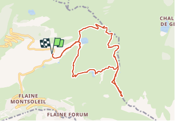
Ruta Senderismo de 11 km a descubrir en Auvergne-Rhône-Alpes, Alta Saboya, Arâches-la-Frasse. Esta ruta ha sido propuesta por le jurassien.39.
Descripción
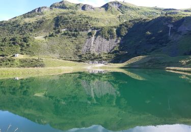
Depuis le parking de Verant monter par la combe Enverse pour le lac de Verant puis les grands vans pour finir la montée au col du Veret.
Localización
País:
France
Región :
Auvergne-Rhône-Alpes
Departamento/provincia :
Alta Saboya
Municipio :
Arâches-la-Frasse
Localidad:
Unknown
Salida:(Dec)
Salida:(UTM)
321142 ; 5098876 (32T) N.
Comentarios
Excursiones cerca
![Excursión Senderismo Samoëns - Lac de Gers - Photo](https://media.geolcdn.com/t/375/260/ext.jpg?maxdim=2&url=https%3A%2F%2Fmedia.geolcdn.com%2Ff%2F4f8c7a90-c8a6-4a64-bc22-de3fbc680b52.jpg)
![Senderismo Senderismo](https://static1.geolcdn.com/sitytour/trail-icons/101.png)
Lac de Gers
Senderismo
Fácil
(1)
Samoëns,
Auvergne-Rhône-Alpes,
Alta Saboya,
France
![](/images/other/stat-length.png)
6,7 km | 11,7 km-effort
2h 39min
![](https://static1.geolcdn.com/siteimages/upload/files/16400158638029165_repeat_loop_refresh_sync_direction_icon.png)
No
![Excursión Senderismo Magland - belvédère d Aulp - Photo](https://media.geolcdn.com/t/375/260/ext.jpg?maxdim=2&url=https%3A%2F%2Fmedia.geolcdn.com%2Ff%2F3d7c42d4-f0a9-4769-9285-e47bef46b3ca.jpg)
![Senderismo Senderismo](https://static1.geolcdn.com/sitytour/trail-icons/101.png)
belvédère d Aulp
Senderismo
Difícil
Magland,
Auvergne-Rhône-Alpes,
Alta Saboya,
France
![](/images/other/stat-length.png)
7,7 km | 14,1 km-effort
4h 2min
![](https://static1.geolcdn.com/siteimages/upload/files/16400158638029165_repeat_loop_refresh_sync_direction_icon.png)
Sí
![Excursión Senderismo Samoëns - plateau des saix . la corne . les biollaires . pointe de cupoire . plateau des saix - Photo](https://media.geolcdn.com/t/375/260/ext.jpg?maxdim=2&url=https%3A%2F%2Fmedia.geolcdn.com%2Ff%2F9a31bcfb-eada-4e13-9da7-575e6de96d67.jpg)
![Senderismo Senderismo](https://static1.geolcdn.com/sitytour/trail-icons/101.png)
plateau des saix . la corne . les biollaires . pointe de cupoire . plateau d...
Senderismo
Medio
Samoëns,
Auvergne-Rhône-Alpes,
Alta Saboya,
France
![](/images/other/stat-length.png)
8,5 km | 15,1 km-effort
3h 54min
![](https://static1.geolcdn.com/siteimages/upload/files/16400158638029165_repeat_loop_refresh_sync_direction_icon.png)
Sí
![Excursión Senderismo Arâches-la-Frasse - Les Tronchets - Photo](https://media.geolcdn.com/t/375/260/ext.jpg?maxdim=2&url=https%3A%2F%2Fmedia.geolcdn.com%2Ff%2F1b22eca5-4d03-4493-9ac5-2c90d211f1bc.jpg)
![Senderismo Senderismo](https://static1.geolcdn.com/sitytour/trail-icons/101.png)
Les Tronchets
Senderismo
Fácil
Arâches-la-Frasse,
Auvergne-Rhône-Alpes,
Alta Saboya,
France
![](/images/other/stat-length.png)
7,4 km | 13,7 km-effort
2h 8min
![](https://static1.geolcdn.com/siteimages/upload/files/16400158638029165_repeat_loop_refresh_sync_direction_icon.png)
Sí
![Excursión Senderismo Arâches-la-Frasse - Vernant Grands Vans par le col de Véret - Photo](https://media.geolcdn.com/t/375/260/ext.jpg?maxdim=2&url=https%3A%2F%2Fmedia.geolcdn.com%2Ff%2F06ee9b71-5751-4664-80a4-c98989797b70.jpg)
![Senderismo Senderismo](https://static1.geolcdn.com/sitytour/trail-icons/101.png)
Vernant Grands Vans par le col de Véret
Senderismo
Fácil
Arâches-la-Frasse,
Auvergne-Rhône-Alpes,
Alta Saboya,
France
![](/images/other/stat-length.png)
7,4 km | 13,4 km-effort
2h 15min
![](https://static1.geolcdn.com/siteimages/upload/files/16400158638029165_repeat_loop_refresh_sync_direction_icon.png)
Sí
![Excursión Senderismo Arâches-la-Frasse - Les Carroz l'Arbaron en boucle - Photo](https://media.geolcdn.com/t/375/260/ext.jpg?maxdim=2&url=https%3A%2F%2Fmedia.geolcdn.com%2Ff%2F360e8a6b-b503-4616-ba4d-4d21ae7c55c0.jpg)
![Senderismo Senderismo](https://static1.geolcdn.com/sitytour/trail-icons/101.png)
Les Carroz l'Arbaron en boucle
Senderismo
Difícil
Arâches-la-Frasse,
Auvergne-Rhône-Alpes,
Alta Saboya,
France
![](/images/other/stat-length.png)
20 km | 33 km-effort
6h 5min
![](https://static1.geolcdn.com/siteimages/upload/files/16400158638029165_repeat_loop_refresh_sync_direction_icon.png)
Sí
![Excursión Senderismo Arâches-la-Frasse - les Carroz, tête de Saix boucle - Photo](https://media.geolcdn.com/t/375/260/ext.jpg?maxdim=2&url=https%3A%2F%2Fmedia.geolcdn.com%2Ff%2Ffc10eab2-e7d0-43c5-ba5e-76349cca3bdc.jpg)
![Senderismo Senderismo](https://static1.geolcdn.com/sitytour/trail-icons/101.png)
les Carroz, tête de Saix boucle
Senderismo
Medio
Arâches-la-Frasse,
Auvergne-Rhône-Alpes,
Alta Saboya,
France
![](/images/other/stat-length.png)
14,1 km | 27 km-effort
4h 8min
![](https://static1.geolcdn.com/siteimages/upload/files/16400158638029165_repeat_loop_refresh_sync_direction_icon.png)
Sí
![Excursión Senderismo Sixt-Fer-à-Cheval - 2020-08-16 Balade Le Giffre Balme Dessus - Photo](https://media.geolcdn.com/t/375/260/ext.jpg?maxdim=2&url=https%3A%2F%2Fmedia.geolcdn.com%2Ff%2F601b2fa8-3a73-40e6-9f26-56e079a7bbe6.jpg)
![Senderismo Senderismo](https://static1.geolcdn.com/sitytour/trail-icons/101.png)
2020-08-16 Balade Le Giffre Balme Dessus
Senderismo
Muy fácil
Sixt-Fer-à-Cheval,
Auvergne-Rhône-Alpes,
Alta Saboya,
France
![](/images/other/stat-length.png)
5,1 km | 7,2 km-effort
1h 23min
![](https://static1.geolcdn.com/siteimages/upload/files/16400158638029165_repeat_loop_refresh_sync_direction_icon.png)
Sí
![Excursión Senderismo Arâches-la-Frasse - Mont Jovy pierre à Laya - Photo](https://media.geolcdn.com/t/375/260/ext.jpg?maxdim=2&url=https%3A%2F%2Fmedia.geolcdn.com%2Ff%2Ff39bd061-a8cf-4891-84d8-c02820fed170.jpg)
![Senderismo Senderismo](https://static1.geolcdn.com/sitytour/trail-icons/101.png)
Mont Jovy pierre à Laya
Senderismo
Muy fácil
Arâches-la-Frasse,
Auvergne-Rhône-Alpes,
Alta Saboya,
France
![](/images/other/stat-length.png)
5,2 km | 7,1 km-effort
1h 26min
![](https://static1.geolcdn.com/siteimages/upload/files/16400158638029165_repeat_loop_refresh_sync_direction_icon.png)
Sí