![](/images/other/stat-length.png)
![Excursión Vaujany - Grand beau rocher de vaujany - Photo](https://media.geolcdn.com/t/1900/400/ext.pjpeg?maxdim=2&url=https%3A%2F%2Fsecurestorage.geolives.com%2Fsitytour%2Ftrail-bg%2Fdefault.jpg)
Grand beau rocher de vaujany
TPOUPLARD
Usuario
![Longitud](/images/other/stat-length.png)
![Altitud máxima](https://static1.geolcdn.com/siteimages/upload/files/1508320355ic_sort_altitude_max_24dp.png)
![Desnivel positivo](https://static1.geolcdn.com/siteimages/upload/files/1508320355ic_sort_den_pos_24dp.png)
![Km-Effort](/images/other/stat-length.png)
![Altitud mínima](https://static1.geolcdn.com/siteimages/upload/files/1508320355ic_sort_altitude_min_24dp.png)
![Desnivel negativo](https://static1.geolcdn.com/siteimages/upload/files/1508320355ic_sort_den_neg_24dp.png)
![Boucle](https://static1.geolcdn.com/siteimages/upload/files/16400158638029165_repeat_loop_refresh_sync_direction_icon.png)
![Escanee este código QR para abrir la excursión en la aplicación SityTrail](https://capi.geolives.com/qq0zvz2zws4bq2lad0pu/sitytour/trails/3792250/qr.png?size=200)
Aplicación GPS de excursión GRATIS
A propósito
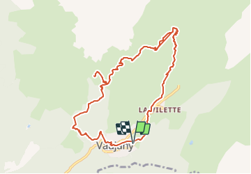
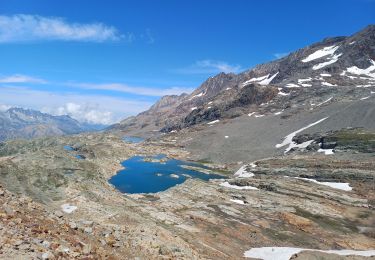
Ruta de 11,3 km a descubrir en Auvergne-Rhône-Alpes, Isère, Vaujany. Esta ruta ha sido propuesta por TPOUPLARD.
Descripción
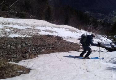
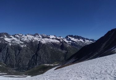
Rando par vaujany jusqu au collet pour voir le magnifique panorama au grand rocher sur les rousses le col du sabot et le col du couard bon dénivelé par moment mais surtout difficile par la longueur le chemin de crete est bien stabilisé par des troncs bref un grand moment de bonheur
Localización
Comentarios
Excursiones cerca
![Excursión Senderismo Vaujany - Sabot aiguillettes couard cochette sabot - Photo](https://media.geolcdn.com/t/375/260/59700ff3-17cf-45a6-9ea3-70b09a5d92db.jpg&format=jpg&maxdim=2)
![Senderismo Senderismo](https://static1.geolcdn.com/sitytour/trail-icons/101.png)
Senderismo
![](/images/other/stat-length.png)
![](https://static1.geolcdn.com/siteimages/upload/files/16400158638029165_repeat_loop_refresh_sync_direction_icon.png)
![Excursión Senderismo Vaujany - Tour des Aiguillettes de Vaujany - Col du Couard - Col du sabot - Photo](https://media.geolcdn.com/t/375/260/ext.jpg?maxdim=2&url=https%3A%2F%2Fservices.sitytrail.com%2FGeolivesWS%2FDownloadMedia.ashx%3FTrailID%3D594369%26Media%3Dfix__20160707150058.jpg)
![Senderismo Senderismo](https://static1.geolcdn.com/sitytour/trail-icons/101.png)
Senderismo
![](/images/other/stat-length.png)
![](https://static1.geolcdn.com/siteimages/upload/files/16400158638029165_repeat_loop_refresh_sync_direction_icon.png)
![Excursión Senderismo Allemond - Lac de Belledonne - Photo](https://media.geolcdn.com/t/375/260/ext.jpg?maxdim=2&url=https%3A%2F%2Fservices.sitytrail.com%2FGeolivesWS%2FDownloadMedia.ashx%3FTrailID%3D325958%26Media%3Dfix__20140719114309.jpg)
![Senderismo Senderismo](https://static1.geolcdn.com/sitytour/trail-icons/101.png)
Senderismo
![](/images/other/stat-length.png)
![](https://static1.geolcdn.com/siteimages/upload/files/16400158638029165_repeat_loop_refresh_sync_direction_icon.png)
![Excursión Senderismo Huez - circuit des lacs, Blanc, du milieu, de la Fare, Balme rousse,dôme des Rousses - Photo](https://media.geolcdn.com/t/375/260/c258a7a0-21e3-440d-bfc0-b7f2c4802255.jpg&format=jpg&maxdim=2)
![Senderismo Senderismo](https://static1.geolcdn.com/sitytour/trail-icons/101.png)
Senderismo
![](/images/other/stat-length.png)
![](https://static1.geolcdn.com/siteimages/upload/files/16400158638029165_repeat_loop_refresh_sync_direction_icon.png)
![Excursión Raquetas de nieve Oz - 2800 m lacs du Milieu de la Fare et Balme rousse AR - Photo](https://media.geolcdn.com/t/375/260/9360f6ea-b2a0-45d2-a0dd-828425529dab.jpg&format=jpg&maxdim=2)
![Raquetas de nieve Raquetas de nieve](https://static1.geolcdn.com/sitytour/trail-icons/504.png)
Raquetas de nieve
![](/images/other/stat-length.png)
![](https://static1.geolcdn.com/siteimages/upload/files/16400158638029165_repeat_loop_refresh_sync_direction_icon.png)
![Excursión Esquí de fondo Vaujany - Aiguillettes de Vaujany et plus - Photo](https://media.geolcdn.com/t/375/260/9ff60b97-d00d-41f8-a1b2-a7c822d88d0d.jpg&format=jpg&maxdim=2)
![Esquí de fondo Esquí de fondo](https://static1.geolcdn.com/sitytour/trail-icons/503.png)
Esquí de fondo
![](/images/other/stat-length.png)
![](https://static1.geolcdn.com/siteimages/upload/files/16400158638029165_repeat_loop_refresh_sync_direction_icon.png)
![Excursión Esquí de fondo Allemond - Brèche de la Roche fendue Est - Photo](https://media.geolcdn.com/t/375/260/bd941ed5-0da8-45b1-ac18-9f9f2876afc2.jpg&format=jpg&maxdim=2)
![Esquí de fondo Esquí de fondo](https://static1.geolcdn.com/sitytour/trail-icons/503.png)
Esquí de fondo
![](/images/other/stat-length.png)
![](https://static1.geolcdn.com/siteimages/upload/files/16400158638029165_repeat_loop_refresh_sync_direction_icon.png)
![Excursión Esquí de fondo Allemond - col PT 2459m près de la gde Lance d'Allemond - Photo](https://media.geolcdn.com/t/375/260/9c8ab575-4333-48a0-9046-13f36910fc12.jpg&format=jpg&maxdim=2)
![Esquí de fondo Esquí de fondo](https://static1.geolcdn.com/sitytour/trail-icons/503.png)
Esquí de fondo
![](/images/other/stat-length.png)
![](https://static1.geolcdn.com/siteimages/upload/files/16400158638029165_repeat_loop_refresh_sync_direction_icon.png)
![Excursión Esquí de fondo Vaujany - les Aiguillettes de Vaujany - Photo](https://media.geolcdn.com/t/375/260/788af54e-431b-4dd3-8f53-2bf8c91793eb.jpg&format=jpg&maxdim=2)
![Esquí de fondo Esquí de fondo](https://static1.geolcdn.com/sitytour/trail-icons/503.png)
Esquí de fondo
![](/images/other/stat-length.png)
![](https://static1.geolcdn.com/siteimages/upload/files/16400158638029165_repeat_loop_refresh_sync_direction_icon.png)