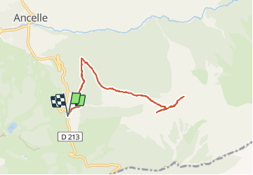
![](/images/other/stat-length.png)
![Excursión Senderismo Ancelle - L'arche et L'aiguille 01/09/23 - Photo](https://media.geolcdn.com/t/1900/400/db1733c9-41d8-4b7e-9a2a-1b7dc4b88cc5.jpg&format=pjpeg&maxdim=2)
L'arche et L'aiguille 01/09/23
R@ph
Usuario GUIDE
![Longitud](/images/other/stat-length.png)
![Altitud máxima](https://static1.geolcdn.com/siteimages/upload/files/1508320355ic_sort_altitude_max_24dp.png)
![Desnivel positivo](https://static1.geolcdn.com/siteimages/upload/files/1508320355ic_sort_den_pos_24dp.png)
![Km-Effort](/images/other/stat-length.png)
![Altitud mínima](https://static1.geolcdn.com/siteimages/upload/files/1508320355ic_sort_altitude_min_24dp.png)
![Desnivel negativo](https://static1.geolcdn.com/siteimages/upload/files/1508320355ic_sort_den_neg_24dp.png)
![Boucle](https://static1.geolcdn.com/siteimages/upload/files/16400158638029165_repeat_loop_refresh_sync_direction_icon.png)
![Senderismo](https://static1.geolcdn.com/sitytour/trail-icons/101.png)
4h27
Dificultad : Muy difícil
![Escanee este código QR para abrir la excursión en la aplicación SityTrail](https://capi.geolives.com/qq0zvz2zws4bq2lad0pu/sitytour/trails/3791818/qr.png?size=200)
Aplicación GPS de excursión GRATIS
A propósito
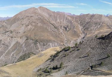
Ruta Senderismo de 8,6 km a descubrir en Provenza-Alpes-Costa Azul, Altos Alpes, Ancelle. Esta ruta ha sido propuesta por R@ph.
Descripción
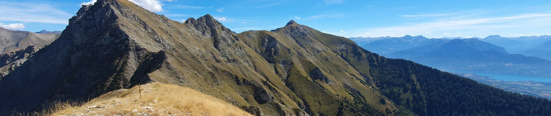
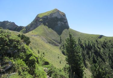
Au départ de Moissière une première partie en sous bois jusqu'au plateau, puis montée au col de L'arche. Une fois au col à droite vous montez à l'Arche, aucune difficulté 200 m en crête, si vous prenez à gauche c'est direction l'Aiguille. Attention ce deuxième sommet est plus exposé que l'Arche, vous serez obligé de passer par une cheminée où il sera indispensable de mettre les mains, ceux qui ne sont pas très surs (il faudra aussi redescendre par là) abstenez vous.
Localización
Comentarios
Excursiones cerca
![Excursión Carrera Ancelle - Ancelle-Tour du Cuchon - Photo](https://media.geolcdn.com/t/375/260/ext.jpg?maxdim=2&url=https%3A%2F%2Fservices.sitytrail.com%2FGeolivesWS%2FDownloadMedia.ashx%3FTrailID%3D220701%26Media%3D20130912111439.jpg)
![Carrera Carrera](https://static1.geolcdn.com/sitytour/trail-icons/103.png)
Carrera
![](/images/other/stat-length.png)
![](https://static1.geolcdn.com/siteimages/upload/files/16400158638029165_repeat_loop_refresh_sync_direction_icon.png)
![Excursión Senderismo Ancelle - Croix Saint Philippe Via Ancelle - Photo](https://media.geolcdn.com/t/375/260/dc5c5efc-aa17-49df-9643-c5a3a69b721c.jpg&format=jpg&maxdim=2)
![Senderismo Senderismo](https://static1.geolcdn.com/sitytour/trail-icons/101.png)
Senderismo
![](/images/other/stat-length.png)
![](https://static1.geolcdn.com/siteimages/upload/files/16400158638029165_repeat_loop_refresh_sync_direction_icon.png)
![Excursión Senderismo Ancelle - col de la coupa et tour de la rouanne - Photo](https://media.geolcdn.com/t/375/260/ext.jpg?maxdim=2&url=https%3A%2F%2Fservices.sitytrail.com%2FGeolivesWS%2FDownloadMedia.ashx%3FTrailID%3D344656%26Media%3Dfix__20140913132149.jpg)
![Senderismo Senderismo](https://static1.geolcdn.com/sitytour/trail-icons/101.png)
Senderismo
![](/images/other/stat-length.png)
![](https://static1.geolcdn.com/siteimages/upload/files/16400158638029165_repeat_loop_refresh_sync_direction_icon.png)
![Excursión Senderismo Ancelle - Le Piolt par la Pourrachiere 21/07/23 - Photo](https://media.geolcdn.com/t/375/260/23f859ba-9c0c-41a5-8a5b-411ad6ec4ecc.jpg&format=jpg&maxdim=2)
![Senderismo Senderismo](https://static1.geolcdn.com/sitytour/trail-icons/101.png)
Senderismo
![](/images/other/stat-length.png)
![](https://static1.geolcdn.com/siteimages/upload/files/16400158638029165_repeat_loop_refresh_sync_direction_icon.png)
![Excursión Senderismo Ancelle - suuntoapp-Hiking-2022-08-29T07-01-11Z - Photo](https://media.geolcdn.com/t/375/260/fcdbf62a-2363-464e-a0a9-f0f396108eb8.jpg&format=jpg&maxdim=2)
![Senderismo Senderismo](https://static1.geolcdn.com/sitytour/trail-icons/101.png)
Senderismo
![](/images/other/stat-length.png)
![](https://static1.geolcdn.com/siteimages/upload/files/16400158638029165_repeat_loop_refresh_sync_direction_icon.png)
![Excursión Senderismo Ancelle - Piolit - Photo](https://media.geolcdn.com/t/375/260/e3289fae-77ac-4123-96ec-1cf1fdd2bfc1.jpg&format=jpg&maxdim=2)
![Senderismo Senderismo](https://static1.geolcdn.com/sitytour/trail-icons/101.png)
Senderismo
![](/images/other/stat-length.png)
![](https://static1.geolcdn.com/siteimages/upload/files/16400158638029165_repeat_loop_refresh_sync_direction_icon.png)
![Excursión Senderismo Ancelle - Cuchon-Petite Autane - Photo](https://media.geolcdn.com/t/375/260/d578de73-ed95-44bf-af1d-1a65af80c427.jpg&format=jpg&maxdim=2)
![Senderismo Senderismo](https://static1.geolcdn.com/sitytour/trail-icons/101.png)
Senderismo
![](/images/other/stat-length.png)
![](https://static1.geolcdn.com/siteimages/upload/files/16400158638029165_repeat_loop_refresh_sync_direction_icon.png)
![Senderismo Senderismo](https://static1.geolcdn.com/sitytour/trail-icons/101.png)
Senderismo
![](/images/other/stat-length.png)
![](https://static1.geolcdn.com/siteimages/upload/files/16400158638029165_repeat_loop_refresh_sync_direction_icon.png)
![Excursión Senderismo Ancelle - Le Piolit par Rouanne Haute 27/09/19 - Photo](https://media.geolcdn.com/t/375/260/aa1c4c93-2e15-4452-8349-0daad3e3624f.jpg&format=jpg&maxdim=2)
![Senderismo Senderismo](https://static1.geolcdn.com/sitytour/trail-icons/101.png)
Senderismo
![](/images/other/stat-length.png)
![](https://static1.geolcdn.com/siteimages/upload/files/16400158638029165_repeat_loop_refresh_sync_direction_icon.png)