![](/images/other/stat-length.png)
![Excursión Senderismo Orcival - Serviere_Aiguiller_T - Photo](https://media.geolcdn.com/t/1900/400/a635b76a-de3d-4665-9ea5-b1e33d468d2c.jpg&format=pjpeg&maxdim=2)
Serviere_Aiguiller_T
force
Usuario
![Longitud](/images/other/stat-length.png)
Longitud
12,2 km
![Altitud máxima](https://static1.geolcdn.com/siteimages/upload/files/1508320355ic_sort_altitude_max_24dp.png)
Altitud máxima
1522 m
![Desnivel positivo](https://static1.geolcdn.com/siteimages/upload/files/1508320355ic_sort_den_pos_24dp.png)
Desnivel positivo
375 m
![Km-Effort](/images/other/stat-length.png)
Km-Effort
17,2 km
![Altitud mínima](https://static1.geolcdn.com/siteimages/upload/files/1508320355ic_sort_altitude_min_24dp.png)
Altitud mínima
1201 m
![Desnivel negativo](https://static1.geolcdn.com/siteimages/upload/files/1508320355ic_sort_den_neg_24dp.png)
Desnivel negativo
375 m
![Boucle](https://static1.geolcdn.com/siteimages/upload/files/16400158638029165_repeat_loop_refresh_sync_direction_icon.png)
Boucle
Sí
Fecha de creación :
2023-08-27 11:56:35.5
Última modificación :
2023-08-28 13:16:59.015
![Senderismo](https://static1.geolcdn.com/sitytour/trail-icons/101.png)
2h46
Dificultad : Difícil
![Escanee este código QR para abrir la excursión en la aplicación SityTrail](https://capi.geolives.com/qq0zvz2zws4bq2lad0pu/sitytour/trails/3786343/qr.png?size=200)
Aplicación GPS de excursión GRATIS
A propósito
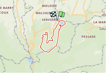
Ruta Senderismo de 12,2 km a descubrir en Auvergne-Rhône-Alpes, Puy-de-Dôme, Orcival. Esta ruta ha sido propuesta por force.
Descripción
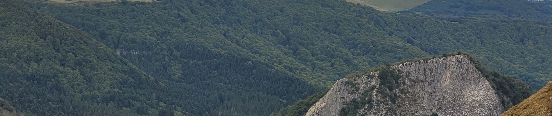
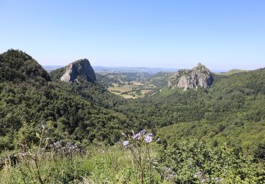
Départ du lac Servière en montant par piste forestière très belles vues sur les chaines de volcans et les lacs
Localización
País:
France
Región :
Auvergne-Rhône-Alpes
Departamento/provincia :
Puy-de-Dôme
Municipio :
Orcival
Localidad:
Unknown
Salida:(Dec)
Salida:(UTM)
488578 ; 5054921 (31T) N.
Comentarios
Excursiones cerca
![Excursión Senderismo Orcival - Lac de Servières à partir du Café du Lac - Photo](https://media.geolcdn.com/t/375/260/d4f759b9-e870-4661-990b-869b6d13ddb5.jpeg&format=jpg&maxdim=2)
![Senderismo Senderismo](https://static1.geolcdn.com/sitytour/trail-icons/101.png)
Lac de Servières à partir du Café du Lac
Senderismo
Medio
(1)
Orcival,
Auvergne-Rhône-Alpes,
Puy-de-Dôme,
France
![](/images/other/stat-length.png)
6,6 km | 9,5 km-effort
2h 9min
![](https://static1.geolcdn.com/siteimages/upload/files/16400158638029165_repeat_loop_refresh_sync_direction_icon.png)
Sí
![Senderismo Senderismo](https://static1.geolcdn.com/sitytour/trail-icons/101.png)
Servieres_Vallee_Sioulot
Senderismo
Medio
(1)
Orcival,
Auvergne-Rhône-Alpes,
Puy-de-Dôme,
France
![](/images/other/stat-length.png)
11,7 km | 16,3 km-effort
3h 30min
![](https://static1.geolcdn.com/siteimages/upload/files/16400158638029165_repeat_loop_refresh_sync_direction_icon.png)
Sí
![Excursión Senderismo Orcival - boucle du Puy de l Ouire - Photo](https://media.geolcdn.com/t/375/260/acae3307-d0e9-457f-8795-cbbba2239bb1.jpg&format=jpg&maxdim=2)
![Senderismo Senderismo](https://static1.geolcdn.com/sitytour/trail-icons/101.png)
boucle du Puy de l Ouire
Senderismo
Medio
(1)
Orcival,
Auvergne-Rhône-Alpes,
Puy-de-Dôme,
France
![](/images/other/stat-length.png)
11,8 km | 16,4 km-effort
4h 14min
![](https://static1.geolcdn.com/siteimages/upload/files/16400158638029165_repeat_loop_refresh_sync_direction_icon.png)
Sí
![Excursión Senderismo Vernines - Vernines_Vallee_Sioule - Photo](https://media.geolcdn.com/t/375/260/38e06b97-31c9-4cc6-a77a-c7870e58965b.jpg&format=jpg&maxdim=2)
![Senderismo Senderismo](https://static1.geolcdn.com/sitytour/trail-icons/101.png)
Vernines_Vallee_Sioule
Senderismo
Medio
(1)
Vernines,
Auvergne-Rhône-Alpes,
Puy-de-Dôme,
France
![](/images/other/stat-length.png)
12,9 km | 16,9 km-effort
3h 45min
![](https://static1.geolcdn.com/siteimages/upload/files/16400158638029165_repeat_loop_refresh_sync_direction_icon.png)
Sí
![Excursión Senderismo Saulzet-le-Froid - Le Puy Baladou - Photo](https://media.geolcdn.com/t/375/260/ext.jpg?maxdim=2&url=https%3A%2F%2Fservices.sitytrail.com%2FGeolivesWS%2FDownloadMedia.ashx%3FTrailID%3D429893%26Media%3Dfix__20150605104830.jpg)
![Senderismo Senderismo](https://static1.geolcdn.com/sitytour/trail-icons/101.png)
Le Puy Baladou
Senderismo
Fácil
(4)
Saulzet-le-Froid,
Auvergne-Rhône-Alpes,
Puy-de-Dôme,
France
![](/images/other/stat-length.png)
12,5 km | 17,3 km-effort
2h 54min
![](https://static1.geolcdn.com/siteimages/upload/files/16400158638029165_repeat_loop_refresh_sync_direction_icon.png)
Sí
![Excursión Senderismo Perpezat - Le lac de Guéry - Photo](https://media.geolcdn.com/t/375/260/ext.jpg?maxdim=2&url=https%3A%2F%2Fservices.sitytrail.com%2FGeolivesWS%2FDownloadMedia.ashx%3FTrailID%3D105682%26Media%3D9516_2.jpg)
![Senderismo Senderismo](https://static1.geolcdn.com/sitytour/trail-icons/101.png)
Le lac de Guéry
Senderismo
Difícil
(2)
Perpezat,
Auvergne-Rhône-Alpes,
Puy-de-Dôme,
France
![](/images/other/stat-length.png)
15 km | 22 km-effort
4h 0min
![](https://static1.geolcdn.com/siteimages/upload/files/16400158638029165_repeat_loop_refresh_sync_direction_icon.png)
Sí
![Excursión Senderismo Perpezat - quelques volcans - Photo](https://media.geolcdn.com/t/375/260/f39b4d03-1fff-4970-9dd3-3ef0b9b4dd15.jpg&format=jpg&maxdim=2)
![Senderismo Senderismo](https://static1.geolcdn.com/sitytour/trail-icons/101.png)
quelques volcans
Senderismo
Difícil
Perpezat,
Auvergne-Rhône-Alpes,
Puy-de-Dôme,
France
![](/images/other/stat-length.png)
11,9 km | 16,9 km-effort
5h 45min
![](https://static1.geolcdn.com/siteimages/upload/files/16400158638029165_repeat_loop_refresh_sync_direction_icon.png)
No
![Excursión A pie Mont-Dore - Le Puy Gros - Photo](https://media.geolcdn.com/t/375/260/57e33af1-6a70-4dc9-a386-d267bcacc7aa.jpeg&format=jpg&maxdim=2)
![A pie A pie](https://static1.geolcdn.com/sitytour/trail-icons/100.png)
Le Puy Gros
A pie
Fácil
(1)
Mont-Dore,
Auvergne-Rhône-Alpes,
Puy-de-Dôme,
France
![](/images/other/stat-length.png)
8,1 km | 13,7 km-effort
3h 6min
![](https://static1.geolcdn.com/siteimages/upload/files/16400158638029165_repeat_loop_refresh_sync_direction_icon.png)
Sí
![Excursión A pie Mont-Dore - Le plateau du Guery - Photo](https://media.geolcdn.com/t/375/260/eb535759-9ccf-4a0b-801d-efa2c6bfc3ac.jpeg&format=jpg&maxdim=2)
![A pie A pie](https://static1.geolcdn.com/sitytour/trail-icons/100.png)
Le plateau du Guery
A pie
Fácil
Mont-Dore,
Auvergne-Rhône-Alpes,
Puy-de-Dôme,
France
![](/images/other/stat-length.png)
12,2 km | 18,4 km-effort
4h 11min
![](https://static1.geolcdn.com/siteimages/upload/files/16400158638029165_repeat_loop_refresh_sync_direction_icon.png)
No