![](/images/other/stat-length.png)
![Excursión Senderismo Sablons sur Huisne - Condé Les Sablons, vallée de l'Huisne - Photo](https://media.geolcdn.com/t/1900/400/eb8eb92b-43d4-4641-a3d8-e02a1195662f.jpg&format=pjpeg&maxdim=2)
Condé Les Sablons, vallée de l'Huisne
jeannine grandjean
Usuario
![Longitud](/images/other/stat-length.png)
![Altitud máxima](https://static1.geolcdn.com/siteimages/upload/files/1508320355ic_sort_altitude_max_24dp.png)
![Desnivel positivo](https://static1.geolcdn.com/siteimages/upload/files/1508320355ic_sort_den_pos_24dp.png)
![Km-Effort](/images/other/stat-length.png)
![Altitud mínima](https://static1.geolcdn.com/siteimages/upload/files/1508320355ic_sort_altitude_min_24dp.png)
![Desnivel negativo](https://static1.geolcdn.com/siteimages/upload/files/1508320355ic_sort_den_neg_24dp.png)
![Boucle](https://static1.geolcdn.com/siteimages/upload/files/16400158638029165_repeat_loop_refresh_sync_direction_icon.png)
![Senderismo](https://static1.geolcdn.com/sitytour/trail-icons/101.png)
3h25
Dificultad : Difícil
![Escanee este código QR para abrir la excursión en la aplicación SityTrail](https://capi.geolives.com/qq0zvz2zws4bq2lad0pu/sitytour/trails/3785079/qr.png?size=200)
Aplicación GPS de excursión GRATIS
A propósito
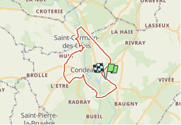
Ruta Senderismo de 13,1 km a descubrir en Normandía, Orne, Sablons sur Huisne. Esta ruta ha sido propuesta por jeannine grandjean.
Descripción
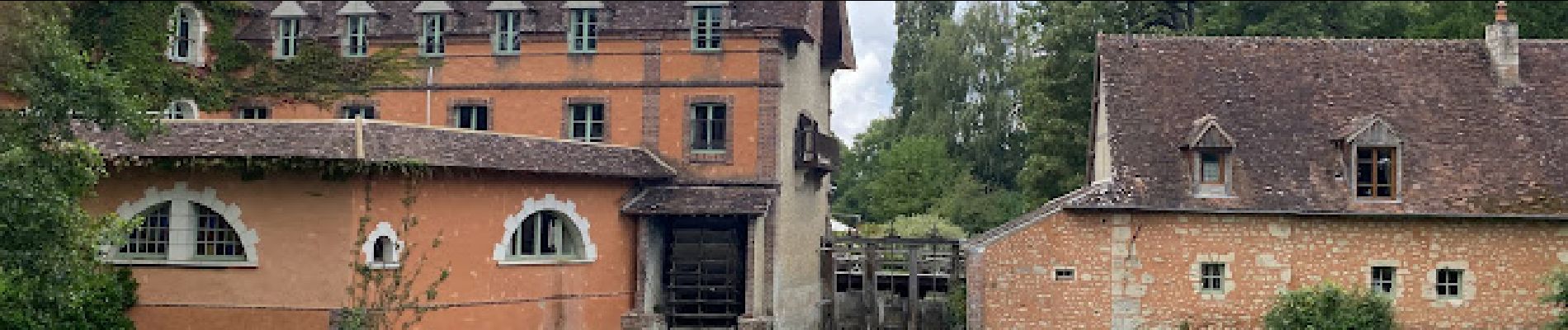
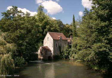
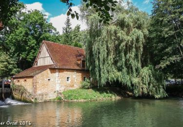
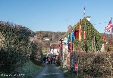
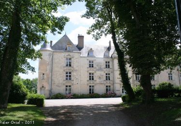
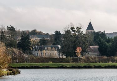
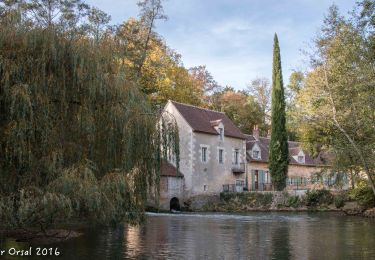
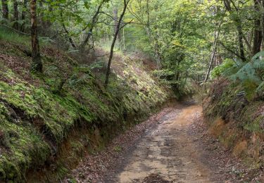
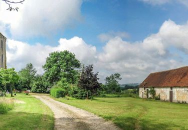
Très belle randonnée dans la vallée de l'Huisne. Départ de Condé, face à l'église. Itinéraire bien balisé, varié, sur des chemins de terre, empierrés ou enherbés, très jolis et très praticables. Quelques petits tronçons de routes de campagne. Traversée de jolis hameaux et particulièrement du village de Villeray avec ses maisons typiques, son château et son superbe moulin.
La dernière partie sur la Voie Verte, longue ligne droite, semble un peu longue en fin de parcours...
Localización
Comentarios
Excursiones cerca
![Excursión Senderismo Rémalard en Perche - La Nymphe du Perche 5,0 Km - Photo](https://media.geolcdn.com/t/375/260/17cc6b0d-b494-41c7-85a0-ede1466ba884.jpg&format=jpg&maxdim=2)
![Senderismo Senderismo](https://static1.geolcdn.com/sitytour/trail-icons/101.png)
Senderismo
![](/images/other/stat-length.png)
![](https://static1.geolcdn.com/siteimages/upload/files/16400158638029165_repeat_loop_refresh_sync_direction_icon.png)
![Excursión Senderismo Sablons sur Huisne - Villeray, au Fil de l'Huisne 11.8 Km - Photo](https://media.geolcdn.com/t/375/260/389a8b4c-26cd-4921-9eb3-f44fb8104715.jpg&format=jpg&maxdim=2)
![Senderismo Senderismo](https://static1.geolcdn.com/sitytour/trail-icons/101.png)
Senderismo
![](/images/other/stat-length.png)
![](https://static1.geolcdn.com/siteimages/upload/files/16400158638029165_repeat_loop_refresh_sync_direction_icon.png)
![Excursión Senderismo Arcisses - 2023-04-24_20h15m45_Ozée 9,1 km - Photo](https://media.geolcdn.com/t/375/260/ext.jpg?maxdim=2&url=https%3A%2F%2Fstatic1.geolcdn.com%2Fsiteimages%2Fupload%2Ffiles%2F1553511878bg_sport_marche.png)
![Senderismo Senderismo](https://static1.geolcdn.com/sitytour/trail-icons/101.png)
Senderismo
![](/images/other/stat-length.png)
![](https://static1.geolcdn.com/siteimages/upload/files/16400158638029165_repeat_loop_refresh_sync_direction_icon.png)
![Excursión Senderismo Sablons sur Huisne - Condé-sur-Huisne - Coudreceau 12 km - Photo](https://media.geolcdn.com/t/375/260/87972a85-bf69-4274-be1a-37d8d7d8a4ac.jpg&format=jpg&maxdim=2)
![Senderismo Senderismo](https://static1.geolcdn.com/sitytour/trail-icons/101.png)
Senderismo
![](/images/other/stat-length.png)
![](https://static1.geolcdn.com/siteimages/upload/files/16400158638029165_repeat_loop_refresh_sync_direction_icon.png)
![Excursión Senderismo Saint-Pierre-la-Bruyère - Condé-sur-Huisne - Saint-Pierre-la-Bruyère via Villeray 8,5 km - Photo](https://media.geolcdn.com/t/375/260/3374e628-d3bf-422a-bb99-175704d9ab1f.jpg&format=jpg&maxdim=2)
![Senderismo Senderismo](https://static1.geolcdn.com/sitytour/trail-icons/101.png)
Senderismo
![](/images/other/stat-length.png)
![](https://static1.geolcdn.com/siteimages/upload/files/16400158638029165_repeat_loop_refresh_sync_direction_icon.png)
![Excursión Senderismo Sablons sur Huisne - Condé-sur-Huisne - Nogent-le-Rotrou via Saint-Pierre-la-Bruyère 11 km - Photo](https://media.geolcdn.com/t/375/260/e847ed75-06a8-4a98-b0e3-0da9e66dfbf2.jpg&format=jpg&maxdim=2)
![Senderismo Senderismo](https://static1.geolcdn.com/sitytour/trail-icons/101.png)
Senderismo
![](/images/other/stat-length.png)
![](https://static1.geolcdn.com/siteimages/upload/files/16400158638029165_repeat_loop_refresh_sync_direction_icon.png)
![Excursión Senderismo Sablons sur Huisne - Condé-sur-Huisne - Rémalard via Villeray 11 km - Photo](https://media.geolcdn.com/t/375/260/8f2a07be-6c5a-402b-acba-3e9821d1fe63.jpg&format=jpg&maxdim=2)
![Senderismo Senderismo](https://static1.geolcdn.com/sitytour/trail-icons/101.png)
Senderismo
![](/images/other/stat-length.png)
![](https://static1.geolcdn.com/siteimages/upload/files/16400158638029165_repeat_loop_refresh_sync_direction_icon.png)
![Excursión Senderismo Sablons sur Huisne - Condé-sur-Huisne - Rémalard via La Courroue 12 km - Photo](https://media.geolcdn.com/t/375/260/4db3e208-edae-4cc2-a089-9ddb16b1768d.jpg&format=jpg&maxdim=2)
![Senderismo Senderismo](https://static1.geolcdn.com/sitytour/trail-icons/101.png)
Senderismo
![](/images/other/stat-length.png)
![](https://static1.geolcdn.com/siteimages/upload/files/16400158638029165_repeat_loop_refresh_sync_direction_icon.png)
![Excursión Senderismo Rémalard en Perche - Sur les pas du Conquérant Variante 13,0 Km - Photo](https://media.geolcdn.com/t/375/260/61fa7ce6-6193-4a21-90b4-c03170a86d13.jpg&format=jpg&maxdim=2)
![Senderismo Senderismo](https://static1.geolcdn.com/sitytour/trail-icons/101.png)
Senderismo
![](/images/other/stat-length.png)
![](https://static1.geolcdn.com/siteimages/upload/files/16400158638029165_repeat_loop_refresh_sync_direction_icon.png)