![](/images/other/stat-length.png)
![Excursión Bici de montaña Vielsalm - Entre vallées du Rechter Bach et de l'Amblève - Photo](https://media.geolcdn.com/t/1900/400/ext.pjpeg?maxdim=2&url=https%3A%2F%2Fstatic1.geolcdn.com%2Fsiteimages%2Fupload%2Ffiles%2F1524743154velo.jpg)
Entre vallées du Rechter Bach et de l'Amblève
Nico222
Usuario
![Longitud](/images/other/stat-length.png)
Longitud
36 km
![Altitud máxima](https://static1.geolcdn.com/siteimages/upload/files/1508320355ic_sort_altitude_max_24dp.png)
Altitud máxima
599 m
![Desnivel positivo](https://static1.geolcdn.com/siteimages/upload/files/1508320355ic_sort_den_pos_24dp.png)
Desnivel positivo
889 m
![Km-Effort](/images/other/stat-length.png)
Km-Effort
48 km
![Altitud mínima](https://static1.geolcdn.com/siteimages/upload/files/1508320355ic_sort_altitude_min_24dp.png)
Altitud mínima
341 m
![Desnivel negativo](https://static1.geolcdn.com/siteimages/upload/files/1508320355ic_sort_den_neg_24dp.png)
Desnivel negativo
883 m
![Boucle](https://static1.geolcdn.com/siteimages/upload/files/16400158638029165_repeat_loop_refresh_sync_direction_icon.png)
Boucle
Sí
Fecha de creación :
2015-01-22 00:00:00.0
Última modificación :
2015-01-22 00:00:00.0
![Bici de montaña](https://static1.geolcdn.com/sitytour/trail-icons/202.png)
3h03
Dificultad : Medio
![Escanee este código QR para abrir la excursión en la aplicación SityTrail](https://capi.geolives.com/qq0zvz2zws4bq2lad0pu/sitytour/trails/377796/qr.png?size=200)
Aplicación GPS de excursión GRATIS
A propósito
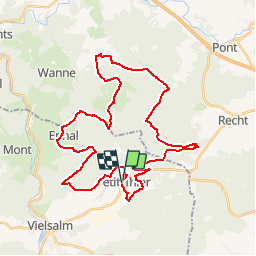
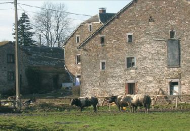
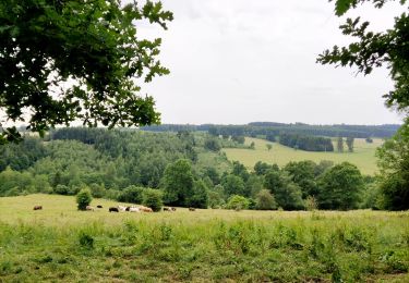
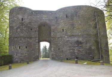
Ruta Bici de montaña de 36 km a descubrir en Valonia, Luxemburgo, Vielsalm. Esta ruta ha sido propuesta por Nico222.
Descripción
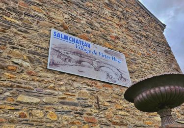
Rejoindre le guide au départ du parking de l'Eglise de Petit-Thier. Attention ce parcours peut être physique à certains endroits. Ne convient pas pour un public familiale.
Localización
País:
Belgium
Región :
Valonia
Departamento/provincia :
Luxemburgo
Municipio :
Vielsalm
Localidad:
Petit-Thier
Salida:(Dec)
Salida:(UTM)
711277 ; 5577022 (31U) N.
Comentarios
Excursiones cerca
![Excursión Senderismo Trois-Ponts - Logbiermé. Natura 2000, des sites qui valent le détour ! Lg5 - Photo](https://media.geolcdn.com/t/375/260/ext.jpg?maxdim=2&url=https%3A%2F%2Fservices.sitytrail.com%2FGeolivesWS%2FDownloadMedia.ashx%3FTrailID%3D142605%26Media%3Db59446be-93ad-402a-bf6d-b5189e61bcf2.JPG)
![Senderismo Senderismo](https://static1.geolcdn.com/sitytour/trail-icons/101.png)
Logbiermé. Natura 2000, des sites qui valent le détour ! Lg5
Senderismo
Fácil
(10)
Trois-Ponts,
Valonia,
Lieja,
Belgium
![](/images/other/stat-length.png)
8,4 km | 10,9 km-effort
Desconocido
![](https://static1.geolcdn.com/siteimages/upload/files/16400158638029165_repeat_loop_refresh_sync_direction_icon.png)
Sí
![Excursión Senderismo Vielsalm - 2023-04-02_15h38m24_Cirkwi-Vielsalm___Pays_du_bois,_de_la_pierre_de_l_eau - Photo](https://media.geolcdn.com/t/375/260/0c677089-4c6a-401e-ab95-09fc62ad11cf.jpg&format=jpg&maxdim=2)
![Senderismo Senderismo](https://static1.geolcdn.com/sitytour/trail-icons/101.png)
2023-04-02_15h38m24_Cirkwi-Vielsalm___Pays_du_bois,_de_la_pierre_de_l_eau
Senderismo
Medio
(2)
Vielsalm,
Valonia,
Luxemburgo,
Belgium
![](/images/other/stat-length.png)
11,6 km | 15,6 km-effort
3h 32min
![](https://static1.geolcdn.com/siteimages/upload/files/16400158638029165_repeat_loop_refresh_sync_direction_icon.png)
Sí
![Excursión Senderismo Vielsalm - GG-Lu-16_Vielsalm - Gouvy - Photo](https://media.geolcdn.com/t/375/260/8dcabdae-2ff1-4908-b3bb-b5309e97313c.jpg&format=jpg&maxdim=2)
![Senderismo Senderismo](https://static1.geolcdn.com/sitytour/trail-icons/101.png)
GG-Lu-16_Vielsalm - Gouvy
Senderismo
Muy difícil
(3)
Vielsalm,
Valonia,
Luxemburgo,
Belgium
![](/images/other/stat-length.png)
16 km | 22 km-effort
4h 48min
![](https://static1.geolcdn.com/siteimages/upload/files/16400158638029165_repeat_loop_refresh_sync_direction_icon.png)
No
![Excursión Senderismo Vielsalm - RB-LUX-03 - Raccourci - Dans les vallées de la Salm et du Glain - Photo](https://media.geolcdn.com/t/375/260/ext.jpg?maxdim=2&url=https%3A%2F%2Fservices.sitytrail.com%2FGeolivesWS%2FDownloadMedia.ashx%3FTrailID%3D216051%26Media%3D51a8d94d-ce85-4f46-8793-517bb65c5b20.jpg)
![Senderismo Senderismo](https://static1.geolcdn.com/sitytour/trail-icons/101.png)
RB-LUX-03 - Raccourci - Dans les vallées de la Salm et du Glain
Senderismo
Fácil
(4)
Vielsalm,
Valonia,
Luxemburgo,
Belgium
![](/images/other/stat-length.png)
16,8 km | 23 km-effort
3h 36min
![](https://static1.geolcdn.com/siteimages/upload/files/16400158638029165_repeat_loop_refresh_sync_direction_icon.png)
Sí
![Excursión Senderismo Vielsalm - RB-LUX-03 - Dans les vallées de la Salm et du Glain - Photo](https://media.geolcdn.com/t/375/260/ext.jpg?maxdim=2&url=https%3A%2F%2Fservices.sitytrail.com%2FGeolivesWS%2FDownloadMedia.ashx%3FTrailID%3D179612%26Media%3Db9c1cda3-4257-4d22-9a9f-65f69e9d8092.jpg)
![Senderismo Senderismo](https://static1.geolcdn.com/sitytour/trail-icons/101.png)
RB-LUX-03 - Dans les vallées de la Salm et du Glain
Senderismo
Medio
(4)
Vielsalm,
Valonia,
Luxemburgo,
Belgium
![](/images/other/stat-length.png)
22 km | 30 km-effort
6h 10min
![](https://static1.geolcdn.com/siteimages/upload/files/16400158638029165_repeat_loop_refresh_sync_direction_icon.png)
Sí
![Excursión Senderismo Vielsalm - Balade à Salmchateau - Photo](https://media.geolcdn.com/t/375/260/3de6bc27-49c3-4a0d-9844-4130c8ac5c83.jpeg&format=jpg&maxdim=2)
![Senderismo Senderismo](https://static1.geolcdn.com/sitytour/trail-icons/101.png)
Balade à Salmchateau
Senderismo
Difícil
Vielsalm,
Valonia,
Luxemburgo,
Belgium
![](/images/other/stat-length.png)
9,8 km | 13,4 km-effort
3h 2min
![](https://static1.geolcdn.com/siteimages/upload/files/16400158638029165_repeat_loop_refresh_sync_direction_icon.png)
Sí
![Excursión Senderismo Vielsalm - La nature en questions - Photo](https://media.geolcdn.com/t/375/260/c82c6954-3937-4349-a2df-80b6eaa40ce3.jpg&format=jpg&maxdim=2)
![Senderismo Senderismo](https://static1.geolcdn.com/sitytour/trail-icons/101.png)
La nature en questions
Senderismo
Medio
Vielsalm,
Valonia,
Luxemburgo,
Belgium
![](/images/other/stat-length.png)
7 km | 9,8 km-effort
2h 13min
![](https://static1.geolcdn.com/siteimages/upload/files/16400158638029165_repeat_loop_refresh_sync_direction_icon.png)
Sí
![Excursión Senderismo Vielsalm - Forêt domaniale du Grand-Bois - Photo](https://media.geolcdn.com/t/375/260/fa7127a4-547c-440c-97b4-37600d149267.jpg&format=jpg&maxdim=2)
![Senderismo Senderismo](https://static1.geolcdn.com/sitytour/trail-icons/101.png)
Forêt domaniale du Grand-Bois
Senderismo
Fácil
Vielsalm,
Valonia,
Luxemburgo,
Belgium
![](/images/other/stat-length.png)
4,1 km | 4,9 km-effort
1h 7min
![](https://static1.geolcdn.com/siteimages/upload/files/16400158638029165_repeat_loop_refresh_sync_direction_icon.png)
Sí
![Senderismo Senderismo](https://static1.geolcdn.com/sitytour/trail-icons/101.png)
20220504 - TOTEMUS Salmchateau 4.3 Km
Senderismo
Medio
Vielsalm,
Valonia,
Luxemburgo,
Belgium
![](/images/other/stat-length.png)
4,2 km | 5,4 km-effort
1h 36min
![](https://static1.geolcdn.com/siteimages/upload/files/16400158638029165_repeat_loop_refresh_sync_direction_icon.png)
Sí