![](/images/other/stat-length.png)
![Excursión Senderismo Civray-de-Touraine - Civray-de-Touraine - boucle Thoré de 12.6km et boucle Civray de 6km - 18.6km 190m 4h25 - 2023 08 16 - Photo](https://media.geolcdn.com/t/1900/400/93c6cdca-83ba-403b-ab65-7bff69e76619.jpg&format=pjpeg&maxdim=2)
Civray-de-Touraine - boucle Thoré de 12.6km et boucle Civray de 6km - 18.6km 190m 4h25 - 2023 08 16
Orcal37
Usuario GUIDE
![Longitud](/images/other/stat-length.png)
Longitud
18,4 km
![Altitud máxima](https://static1.geolcdn.com/siteimages/upload/files/1508320355ic_sort_altitude_max_24dp.png)
Altitud máxima
117 m
![Desnivel positivo](https://static1.geolcdn.com/siteimages/upload/files/1508320355ic_sort_den_pos_24dp.png)
Desnivel positivo
189 m
![Km-Effort](/images/other/stat-length.png)
Km-Effort
21 km
![Altitud mínima](https://static1.geolcdn.com/siteimages/upload/files/1508320355ic_sort_altitude_min_24dp.png)
Altitud mínima
52 m
![Desnivel negativo](https://static1.geolcdn.com/siteimages/upload/files/1508320355ic_sort_den_neg_24dp.png)
Desnivel negativo
189 m
![Boucle](https://static1.geolcdn.com/siteimages/upload/files/16400158638029165_repeat_loop_refresh_sync_direction_icon.png)
Boucle
Sí
Fecha de creación :
2023-08-16 11:43:58.738
Última modificación :
2023-08-30 07:18:04.182
![Senderismo](https://static1.geolcdn.com/sitytour/trail-icons/101.png)
4h25
Dificultad : Fácil
![Escanee este código QR para abrir la excursión en la aplicación SityTrail](https://capi.geolives.com/qq0zvz2zws4bq2lad0pu/sitytour/trails/3774376/qr.png?size=200)
Aplicación GPS de excursión GRATIS
A propósito
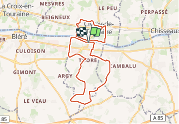
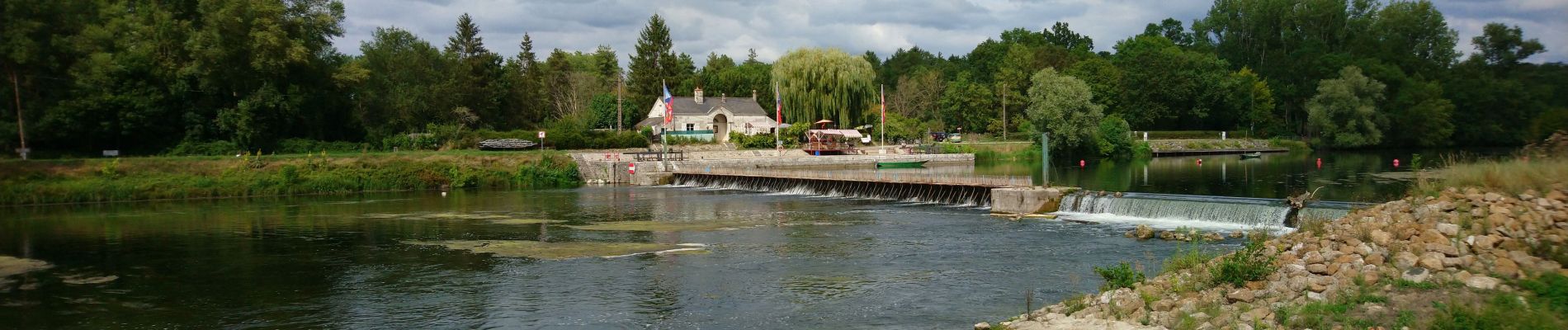
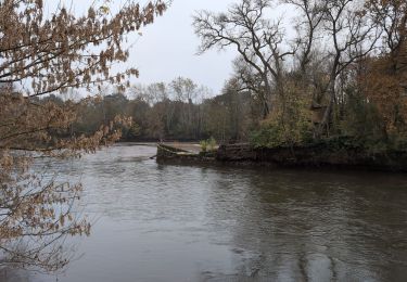
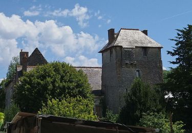
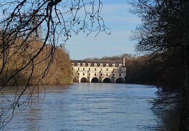
Ruta Senderismo de 18,4 km a descubrir en Centro, Indre y Loira, Civray-de-Touraine. Esta ruta ha sido propuesta por Orcal37.
Descripción
Civray-de-Touraine - boucle Thoré de 12.6km et boucle Civray de 6km - 18.6km 190m 4h25 - 2023 08 16
Localización
País:
France
Región :
Centro
Departamento/provincia :
Indre y Loira
Municipio :
Civray-de-Touraine
Localidad:
Unknown
Salida:(Dec)
Salida:(UTM)
351893 ; 5243144 (31T) N.
Comentarios
Excursiones cerca
![Excursión Senderismo Luzillé - les petits gars - Photo](https://media.geolcdn.com/t/375/260/ext.jpg?maxdim=2&url=https%3A%2F%2Fservices.sitytrail.com%2FGeolivesWS%2FDownloadMedia.ashx%3FTrailID%3D740867%26Media%3Dfix__20170427113816.jpg)
![Senderismo Senderismo](https://static1.geolcdn.com/sitytour/trail-icons/101.png)
les petits gars
Senderismo
Muy fácil
(1)
Luzillé,
Centro,
Indre y Loira,
France
![](/images/other/stat-length.png)
6,7 km | 7,3 km-effort
2h 13min
![](https://static1.geolcdn.com/siteimages/upload/files/16400158638029165_repeat_loop_refresh_sync_direction_icon.png)
Sí
![Excursión Senderismo Civray-de-Touraine - Civray-de-Touraine - Zig Zag Chenonceaux Chisseaux - 26.2km 380m 6h10 (40mn) - 2024 11 16 - Photo](https://media.geolcdn.com/t/375/260/b928cfcf-95b5-4db7-9805-1e2be5eb479d.jpg&format=jpg&maxdim=2)
![Senderismo Senderismo](https://static1.geolcdn.com/sitytour/trail-icons/101.png)
Civray-de-Touraine - Zig Zag Chenonceaux Chisseaux - 26.2km 380m 6h10 (40mn) ...
Senderismo
Fácil
Civray-de-Touraine,
Centro,
Indre y Loira,
France
![](/images/other/stat-length.png)
26 km | 31 km-effort
6h 10min
![](https://static1.geolcdn.com/siteimages/upload/files/16400158638029165_repeat_loop_refresh_sync_direction_icon.png)
Sí
![Excursión Senderismo La Croix-en-Touraine - la Croix-en-Touraine - 16.4km 150m 3h50 (30mn) - 2023 07 08 - Photo](https://media.geolcdn.com/t/375/260/2678fd2f-7ce4-496a-8544-610b3f2f9e63.jpg&format=jpg&maxdim=2)
![Senderismo Senderismo](https://static1.geolcdn.com/sitytour/trail-icons/101.png)
la Croix-en-Touraine - 16.4km 150m 3h50 (30mn) - 2023 07 08
Senderismo
Difícil
La Croix-en-Touraine,
Centro,
Indre y Loira,
France
![](/images/other/stat-length.png)
16,4 km | 18,5 km-effort
4h 11min
![](https://static1.geolcdn.com/siteimages/upload/files/16400158638029165_repeat_loop_refresh_sync_direction_icon.png)
Sí
![Excursión Senderismo Bléré - Bléré - Fonds de Bout Ferré - 14.2km 145m 3h30 - 2022 08 15 - Photo](https://media.geolcdn.com/t/375/260/3f6831ff-189b-444c-8755-d6d9f4110c27.jpg&format=jpg&maxdim=2)
![Senderismo Senderismo](https://static1.geolcdn.com/sitytour/trail-icons/101.png)
Bléré - Fonds de Bout Ferré - 14.2km 145m 3h30 - 2022 08 15
Senderismo
Fácil
Bléré,
Centro,
Indre y Loira,
France
![](/images/other/stat-length.png)
14,2 km | 16,2 km-effort
3h 30min
![](https://static1.geolcdn.com/siteimages/upload/files/16400158638029165_repeat_loop_refresh_sync_direction_icon.png)
Sí
![Excursión Senderismo Francueil - Chenonceaux - GR41 Francueil - 12.7km 160m 2h45 - 2022 01 01 - Photo](https://media.geolcdn.com/t/375/260/d77c3233-33cb-4dd7-bc1d-c59e94e3839d.jpg&format=jpg&maxdim=2)
![Senderismo Senderismo](https://static1.geolcdn.com/sitytour/trail-icons/101.png)
Chenonceaux - GR41 Francueil - 12.7km 160m 2h45 - 2022 01 01
Senderismo
Fácil
Francueil,
Centro,
Indre y Loira,
France
![](/images/other/stat-length.png)
12,7 km | 14,8 km-effort
2h 45min
![](https://static1.geolcdn.com/siteimages/upload/files/16400158638029165_repeat_loop_refresh_sync_direction_icon.png)
Sí
![Excursión Senderismo Chenonceaux - Chenonceaux - Photo](https://media.geolcdn.com/t/375/260/ext.jpg?maxdim=2&url=https%3A%2F%2Fstatic1.geolcdn.com%2Fsiteimages%2Fupload%2Ffiles%2F1553511878bg_sport_marche.png)
![Senderismo Senderismo](https://static1.geolcdn.com/sitytour/trail-icons/101.png)
Chenonceaux
Senderismo
Fácil
(1)
Chenonceaux,
Centro,
Indre y Loira,
France
![](/images/other/stat-length.png)
10,9 km | 13,1 km-effort
2h 50min
![](https://static1.geolcdn.com/siteimages/upload/files/16400158638029165_repeat_loop_refresh_sync_direction_icon.png)
Sí
![Excursión Senderismo Bléré - Bléré - la Fontaine aux Oiseaux - 17.6km 150m 3h30 - 2007 10 13 - Photo](https://media.geolcdn.com/t/375/260/d2254c58-83ae-47f4-a7e6-4911a659a586.jpg&format=jpg&maxdim=2)
![Senderismo Senderismo](https://static1.geolcdn.com/sitytour/trail-icons/101.png)
Bléré - la Fontaine aux Oiseaux - 17.6km 150m 3h30 - 2007 10 13
Senderismo
Fácil
Bléré,
Centro,
Indre y Loira,
France
![](/images/other/stat-length.png)
17,6 km | 19,6 km-effort
3h 30min
![](https://static1.geolcdn.com/siteimages/upload/files/16400158638029165_repeat_loop_refresh_sync_direction_icon.png)
Sí
![Excursión Senderismo Chisseaux - Château de Chenonceau - Photo](https://media.geolcdn.com/t/375/260/6206e504-db24-466b-a356-564f25506480.jpg&format=jpg&maxdim=2)
![Senderismo Senderismo](https://static1.geolcdn.com/sitytour/trail-icons/101.png)
Château de Chenonceau
Senderismo
Muy fácil
Chisseaux,
Centro,
Indre y Loira,
France
![](/images/other/stat-length.png)
20 km | 22 km-effort
4h 45min
![](https://static1.geolcdn.com/siteimages/upload/files/16400158638029165_repeat_loop_refresh_sync_direction_icon.png)
Sí
![Excursión Senderismo Chisseaux - 538885 - Photo](https://media.geolcdn.com/t/375/260/ext.jpg?maxdim=2&url=https%3A%2F%2Fstatic1.geolcdn.com%2Fsiteimages%2Fupload%2Ffiles%2F1553511878bg_sport_marche.png)
![Senderismo Senderismo](https://static1.geolcdn.com/sitytour/trail-icons/101.png)
538885
Senderismo
Fácil
(1)
Chisseaux,
Centro,
Indre y Loira,
France
![](/images/other/stat-length.png)
19,2 km | 22 km-effort
4h 47min
![](https://static1.geolcdn.com/siteimages/upload/files/16400158638029165_repeat_loop_refresh_sync_direction_icon.png)
Sí