


9,2 km | 14,1 km-effort

Usuario GUIDE


Aplicación GPS de excursión GRATIS
 SityTrail
IGN / Institutos geográficos
SityTrail World
El mundo es suyo
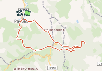
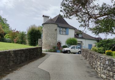
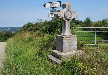
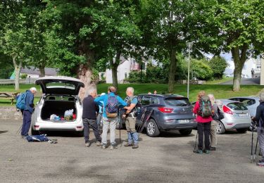
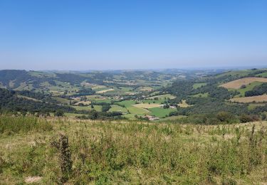
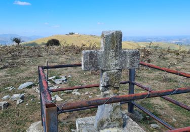
Ruta Senderismo de 10,3 km a descubrir en Nueva Aquitania, Pirineos-Atlánticos, Pagolle. Esta ruta ha sido propuesta por marmotte65.
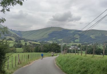
Superbe mais vraiment superbe balade malgré le goudron du départ en montant et le goudron du retour en descendant.
De superbes point de vue tout le long de la rando allez-y, vous ne serez pas déçu.
Et le PN à la chapelle Saint Gregoire au top a l'ombre sous des arbres magnifiques
 "
data-pinterest-text="Pin it"
data-tweet-text="share on twitter"
data-facebook-share-url="https://www.sitytrail.com/es/trails/3767853-pagolle--pagolle-et-la-chapelle-st-gregoire-g3-x3767853x/?photo=1#lg=1&slide=1"
data-twitter-share-url="https://www.sitytrail.com/es/trails/3767853-pagolle--pagolle-et-la-chapelle-st-gregoire-g3-x3767853x/?photo=1#lg=1&slide=1"
data-googleplus-share-url="https://www.sitytrail.com/es/trails/3767853-pagolle--pagolle-et-la-chapelle-st-gregoire-g3-x3767853x/?photo=1#lg=1&slide=1"
data-pinterest-share-url="https://www.sitytrail.com/es/trails/3767853-pagolle--pagolle-et-la-chapelle-st-gregoire-g3-x3767853x/?photo=1#lg=1&slide=1">
"
data-pinterest-text="Pin it"
data-tweet-text="share on twitter"
data-facebook-share-url="https://www.sitytrail.com/es/trails/3767853-pagolle--pagolle-et-la-chapelle-st-gregoire-g3-x3767853x/?photo=1#lg=1&slide=1"
data-twitter-share-url="https://www.sitytrail.com/es/trails/3767853-pagolle--pagolle-et-la-chapelle-st-gregoire-g3-x3767853x/?photo=1#lg=1&slide=1"
data-googleplus-share-url="https://www.sitytrail.com/es/trails/3767853-pagolle--pagolle-et-la-chapelle-st-gregoire-g3-x3767853x/?photo=1#lg=1&slide=1"
data-pinterest-share-url="https://www.sitytrail.com/es/trails/3767853-pagolle--pagolle-et-la-chapelle-st-gregoire-g3-x3767853x/?photo=1#lg=1&slide=1">
 "
data-pinterest-text="Pin it"
data-tweet-text="share on twitter"
data-facebook-share-url="https://www.sitytrail.com/es/trails/3767853-pagolle--pagolle-et-la-chapelle-st-gregoire-g3-x3767853x/?photo=2#lg=1&slide=2"
data-twitter-share-url="https://www.sitytrail.com/es/trails/3767853-pagolle--pagolle-et-la-chapelle-st-gregoire-g3-x3767853x/?photo=2#lg=1&slide=2"
data-googleplus-share-url="https://www.sitytrail.com/es/trails/3767853-pagolle--pagolle-et-la-chapelle-st-gregoire-g3-x3767853x/?photo=2#lg=1&slide=2"
data-pinterest-share-url="https://www.sitytrail.com/es/trails/3767853-pagolle--pagolle-et-la-chapelle-st-gregoire-g3-x3767853x/?photo=2#lg=1&slide=2">
"
data-pinterest-text="Pin it"
data-tweet-text="share on twitter"
data-facebook-share-url="https://www.sitytrail.com/es/trails/3767853-pagolle--pagolle-et-la-chapelle-st-gregoire-g3-x3767853x/?photo=2#lg=1&slide=2"
data-twitter-share-url="https://www.sitytrail.com/es/trails/3767853-pagolle--pagolle-et-la-chapelle-st-gregoire-g3-x3767853x/?photo=2#lg=1&slide=2"
data-googleplus-share-url="https://www.sitytrail.com/es/trails/3767853-pagolle--pagolle-et-la-chapelle-st-gregoire-g3-x3767853x/?photo=2#lg=1&slide=2"
data-pinterest-share-url="https://www.sitytrail.com/es/trails/3767853-pagolle--pagolle-et-la-chapelle-st-gregoire-g3-x3767853x/?photo=2#lg=1&slide=2">
 "
data-pinterest-text="Pin it"
data-tweet-text="share on twitter"
data-facebook-share-url="https://www.sitytrail.com/es/trails/3767853-pagolle--pagolle-et-la-chapelle-st-gregoire-g3-x3767853x/?photo=3#lg=1&slide=3"
data-twitter-share-url="https://www.sitytrail.com/es/trails/3767853-pagolle--pagolle-et-la-chapelle-st-gregoire-g3-x3767853x/?photo=3#lg=1&slide=3"
data-googleplus-share-url="https://www.sitytrail.com/es/trails/3767853-pagolle--pagolle-et-la-chapelle-st-gregoire-g3-x3767853x/?photo=3#lg=1&slide=3"
data-pinterest-share-url="https://www.sitytrail.com/es/trails/3767853-pagolle--pagolle-et-la-chapelle-st-gregoire-g3-x3767853x/?photo=3#lg=1&slide=3">
"
data-pinterest-text="Pin it"
data-tweet-text="share on twitter"
data-facebook-share-url="https://www.sitytrail.com/es/trails/3767853-pagolle--pagolle-et-la-chapelle-st-gregoire-g3-x3767853x/?photo=3#lg=1&slide=3"
data-twitter-share-url="https://www.sitytrail.com/es/trails/3767853-pagolle--pagolle-et-la-chapelle-st-gregoire-g3-x3767853x/?photo=3#lg=1&slide=3"
data-googleplus-share-url="https://www.sitytrail.com/es/trails/3767853-pagolle--pagolle-et-la-chapelle-st-gregoire-g3-x3767853x/?photo=3#lg=1&slide=3"
data-pinterest-share-url="https://www.sitytrail.com/es/trails/3767853-pagolle--pagolle-et-la-chapelle-st-gregoire-g3-x3767853x/?photo=3#lg=1&slide=3">
 "
data-pinterest-text="Pin it"
data-tweet-text="share on twitter"
data-facebook-share-url="https://www.sitytrail.com/es/trails/3767853-pagolle--pagolle-et-la-chapelle-st-gregoire-g3-x3767853x/?photo=4#lg=1&slide=4"
data-twitter-share-url="https://www.sitytrail.com/es/trails/3767853-pagolle--pagolle-et-la-chapelle-st-gregoire-g3-x3767853x/?photo=4#lg=1&slide=4"
data-googleplus-share-url="https://www.sitytrail.com/es/trails/3767853-pagolle--pagolle-et-la-chapelle-st-gregoire-g3-x3767853x/?photo=4#lg=1&slide=4"
data-pinterest-share-url="https://www.sitytrail.com/es/trails/3767853-pagolle--pagolle-et-la-chapelle-st-gregoire-g3-x3767853x/?photo=4#lg=1&slide=4">
"
data-pinterest-text="Pin it"
data-tweet-text="share on twitter"
data-facebook-share-url="https://www.sitytrail.com/es/trails/3767853-pagolle--pagolle-et-la-chapelle-st-gregoire-g3-x3767853x/?photo=4#lg=1&slide=4"
data-twitter-share-url="https://www.sitytrail.com/es/trails/3767853-pagolle--pagolle-et-la-chapelle-st-gregoire-g3-x3767853x/?photo=4#lg=1&slide=4"
data-googleplus-share-url="https://www.sitytrail.com/es/trails/3767853-pagolle--pagolle-et-la-chapelle-st-gregoire-g3-x3767853x/?photo=4#lg=1&slide=4"
data-pinterest-share-url="https://www.sitytrail.com/es/trails/3767853-pagolle--pagolle-et-la-chapelle-st-gregoire-g3-x3767853x/?photo=4#lg=1&slide=4">
 "
data-pinterest-text="Pin it"
data-tweet-text="share on twitter"
data-facebook-share-url="https://www.sitytrail.com/es/trails/3767853-pagolle--pagolle-et-la-chapelle-st-gregoire-g3-x3767853x/?photo=5#lg=1&slide=5"
data-twitter-share-url="https://www.sitytrail.com/es/trails/3767853-pagolle--pagolle-et-la-chapelle-st-gregoire-g3-x3767853x/?photo=5#lg=1&slide=5"
data-googleplus-share-url="https://www.sitytrail.com/es/trails/3767853-pagolle--pagolle-et-la-chapelle-st-gregoire-g3-x3767853x/?photo=5#lg=1&slide=5"
data-pinterest-share-url="https://www.sitytrail.com/es/trails/3767853-pagolle--pagolle-et-la-chapelle-st-gregoire-g3-x3767853x/?photo=5#lg=1&slide=5">
"
data-pinterest-text="Pin it"
data-tweet-text="share on twitter"
data-facebook-share-url="https://www.sitytrail.com/es/trails/3767853-pagolle--pagolle-et-la-chapelle-st-gregoire-g3-x3767853x/?photo=5#lg=1&slide=5"
data-twitter-share-url="https://www.sitytrail.com/es/trails/3767853-pagolle--pagolle-et-la-chapelle-st-gregoire-g3-x3767853x/?photo=5#lg=1&slide=5"
data-googleplus-share-url="https://www.sitytrail.com/es/trails/3767853-pagolle--pagolle-et-la-chapelle-st-gregoire-g3-x3767853x/?photo=5#lg=1&slide=5"
data-pinterest-share-url="https://www.sitytrail.com/es/trails/3767853-pagolle--pagolle-et-la-chapelle-st-gregoire-g3-x3767853x/?photo=5#lg=1&slide=5">
 "
data-pinterest-text="Pin it"
data-tweet-text="share on twitter"
data-facebook-share-url="https://www.sitytrail.com/es/trails/3767853-pagolle--pagolle-et-la-chapelle-st-gregoire-g3-x3767853x/?photo=6#lg=1&slide=6"
data-twitter-share-url="https://www.sitytrail.com/es/trails/3767853-pagolle--pagolle-et-la-chapelle-st-gregoire-g3-x3767853x/?photo=6#lg=1&slide=6"
data-googleplus-share-url="https://www.sitytrail.com/es/trails/3767853-pagolle--pagolle-et-la-chapelle-st-gregoire-g3-x3767853x/?photo=6#lg=1&slide=6"
data-pinterest-share-url="https://www.sitytrail.com/es/trails/3767853-pagolle--pagolle-et-la-chapelle-st-gregoire-g3-x3767853x/?photo=6#lg=1&slide=6">
"
data-pinterest-text="Pin it"
data-tweet-text="share on twitter"
data-facebook-share-url="https://www.sitytrail.com/es/trails/3767853-pagolle--pagolle-et-la-chapelle-st-gregoire-g3-x3767853x/?photo=6#lg=1&slide=6"
data-twitter-share-url="https://www.sitytrail.com/es/trails/3767853-pagolle--pagolle-et-la-chapelle-st-gregoire-g3-x3767853x/?photo=6#lg=1&slide=6"
data-googleplus-share-url="https://www.sitytrail.com/es/trails/3767853-pagolle--pagolle-et-la-chapelle-st-gregoire-g3-x3767853x/?photo=6#lg=1&slide=6"
data-pinterest-share-url="https://www.sitytrail.com/es/trails/3767853-pagolle--pagolle-et-la-chapelle-st-gregoire-g3-x3767853x/?photo=6#lg=1&slide=6">
 "
data-pinterest-text="Pin it"
data-tweet-text="share on twitter"
data-facebook-share-url="https://www.sitytrail.com/es/trails/3767853-pagolle--pagolle-et-la-chapelle-st-gregoire-g3-x3767853x/?photo=7#lg=1&slide=7"
data-twitter-share-url="https://www.sitytrail.com/es/trails/3767853-pagolle--pagolle-et-la-chapelle-st-gregoire-g3-x3767853x/?photo=7#lg=1&slide=7"
data-googleplus-share-url="https://www.sitytrail.com/es/trails/3767853-pagolle--pagolle-et-la-chapelle-st-gregoire-g3-x3767853x/?photo=7#lg=1&slide=7"
data-pinterest-share-url="https://www.sitytrail.com/es/trails/3767853-pagolle--pagolle-et-la-chapelle-st-gregoire-g3-x3767853x/?photo=7#lg=1&slide=7">
"
data-pinterest-text="Pin it"
data-tweet-text="share on twitter"
data-facebook-share-url="https://www.sitytrail.com/es/trails/3767853-pagolle--pagolle-et-la-chapelle-st-gregoire-g3-x3767853x/?photo=7#lg=1&slide=7"
data-twitter-share-url="https://www.sitytrail.com/es/trails/3767853-pagolle--pagolle-et-la-chapelle-st-gregoire-g3-x3767853x/?photo=7#lg=1&slide=7"
data-googleplus-share-url="https://www.sitytrail.com/es/trails/3767853-pagolle--pagolle-et-la-chapelle-st-gregoire-g3-x3767853x/?photo=7#lg=1&slide=7"
data-pinterest-share-url="https://www.sitytrail.com/es/trails/3767853-pagolle--pagolle-et-la-chapelle-st-gregoire-g3-x3767853x/?photo=7#lg=1&slide=7">
 "
data-pinterest-text="Pin it"
data-tweet-text="share on twitter"
data-facebook-share-url="https://www.sitytrail.com/es/trails/3767853-pagolle--pagolle-et-la-chapelle-st-gregoire-g3-x3767853x/?photo=8#lg=1&slide=8"
data-twitter-share-url="https://www.sitytrail.com/es/trails/3767853-pagolle--pagolle-et-la-chapelle-st-gregoire-g3-x3767853x/?photo=8#lg=1&slide=8"
data-googleplus-share-url="https://www.sitytrail.com/es/trails/3767853-pagolle--pagolle-et-la-chapelle-st-gregoire-g3-x3767853x/?photo=8#lg=1&slide=8"
data-pinterest-share-url="https://www.sitytrail.com/es/trails/3767853-pagolle--pagolle-et-la-chapelle-st-gregoire-g3-x3767853x/?photo=8#lg=1&slide=8">
"
data-pinterest-text="Pin it"
data-tweet-text="share on twitter"
data-facebook-share-url="https://www.sitytrail.com/es/trails/3767853-pagolle--pagolle-et-la-chapelle-st-gregoire-g3-x3767853x/?photo=8#lg=1&slide=8"
data-twitter-share-url="https://www.sitytrail.com/es/trails/3767853-pagolle--pagolle-et-la-chapelle-st-gregoire-g3-x3767853x/?photo=8#lg=1&slide=8"
data-googleplus-share-url="https://www.sitytrail.com/es/trails/3767853-pagolle--pagolle-et-la-chapelle-st-gregoire-g3-x3767853x/?photo=8#lg=1&slide=8"
data-pinterest-share-url="https://www.sitytrail.com/es/trails/3767853-pagolle--pagolle-et-la-chapelle-st-gregoire-g3-x3767853x/?photo=8#lg=1&slide=8">


Senderismo

Senderismo
Senderismo
Senderismo
Senderismo
Senderismo

A pie
Senderismo
Senderismo