![](/images/other/stat-length.png)
![Excursión Senderismo Val de Bagnes - La Haute Route : J3 - Photo](https://media.geolcdn.com/t/1900/400/59993d24-fe9a-46fc-9cf0-b7bd0596c6a1.jpg&format=pjpeg&maxdim=2)
La Haute Route : J3
Greg813
Usuario
![Longitud](/images/other/stat-length.png)
![Altitud máxima](https://static1.geolcdn.com/siteimages/upload/files/1508320355ic_sort_altitude_max_24dp.png)
![Desnivel positivo](https://static1.geolcdn.com/siteimages/upload/files/1508320355ic_sort_den_pos_24dp.png)
![Km-Effort](/images/other/stat-length.png)
![Altitud mínima](https://static1.geolcdn.com/siteimages/upload/files/1508320355ic_sort_altitude_min_24dp.png)
![Desnivel negativo](https://static1.geolcdn.com/siteimages/upload/files/1508320355ic_sort_den_neg_24dp.png)
![Boucle](https://static1.geolcdn.com/siteimages/upload/files/16400158638029165_repeat_loop_refresh_sync_direction_icon.png)
![Senderismo](https://static1.geolcdn.com/sitytour/trail-icons/101.png)
4h54
Dificultad : Difícil
![Escanee este código QR para abrir la excursión en la aplicación SityTrail](https://capi.geolives.com/qq0zvz2zws4bq2lad0pu/sitytour/trails/3765255/qr.png?size=200)
Aplicación GPS de excursión GRATIS
A propósito
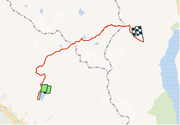
Ruta Senderismo de 11,8 km a descubrir en Vallés, Entremont, Val de Bagnes. Esta ruta ha sido propuesta por Greg813.
Descripción
Trek de 10 jours dans le Valais suisse avec Mettons le Monde en Marche. Parcours de la Haute Route Chamonix-Zermatt avec nuits en refuge.
Etape 2 : Cabane de Louvie – Cabane de Prafleuri
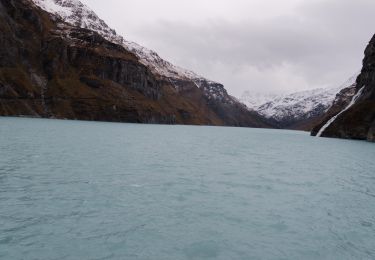
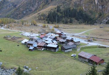
Pour d'autres photos, voir le site de l'association :
https://mmm-rando.org/la-presque-haute-route-chable-zermatt/
Localización
Comentarios
Excursiones cerca
![Excursión A pie Val de Bagnes - Ancien Bisse du Levron - Photo](https://media.geolcdn.com/t/375/260/80610014-2440-48cc-bb45-b16896750006.jpeg&format=jpg&maxdim=2)
![A pie A pie](https://static1.geolcdn.com/sitytour/trail-icons/100.png)
A pie
![](/images/other/stat-length.png)
![](https://static1.geolcdn.com/siteimages/upload/files/16400158638029165_repeat_loop_refresh_sync_direction_icon.png)
![Excursión A pie Val de Bagnes - Fionnay-Bonatchiesse - Photo](https://media.geolcdn.com/t/375/260/722b9f42-8e6c-40c8-97d5-9a76a6e7f852.jpeg&format=jpg&maxdim=2)
![A pie A pie](https://static1.geolcdn.com/sitytour/trail-icons/100.png)
A pie
![](/images/other/stat-length.png)
![](https://static1.geolcdn.com/siteimages/upload/files/16400158638029165_repeat_loop_refresh_sync_direction_icon.png)
![Excursión A pie Val de Bagnes - Louvie-Fionnay - Photo](https://media.geolcdn.com/t/375/260/5fd2d0df-c707-4ac6-b9ec-327205fb196f.jpeg&format=jpg&maxdim=2)
![A pie A pie](https://static1.geolcdn.com/sitytour/trail-icons/100.png)
A pie
![](/images/other/stat-length.png)
![](https://static1.geolcdn.com/siteimages/upload/files/16400158638029165_repeat_loop_refresh_sync_direction_icon.png)
![Excursión A pie Val de Bagnes - Col Termin-Louvie - Photo](https://media.geolcdn.com/t/375/260/5fd2d0df-c707-4ac6-b9ec-327205fb196f.jpeg&format=jpg&maxdim=2)
![A pie A pie](https://static1.geolcdn.com/sitytour/trail-icons/100.png)
A pie
![](/images/other/stat-length.png)
![](https://static1.geolcdn.com/siteimages/upload/files/16400158638029165_repeat_loop_refresh_sync_direction_icon.png)
![Excursión Senderismo Val de Bagnes - Mauvoisin Bonatchiesse - Photo](https://media.geolcdn.com/t/375/260/d8ed992b-e50a-48df-a959-9a284479d634.jpg&format=jpg&maxdim=2)
![Senderismo Senderismo](https://static1.geolcdn.com/sitytour/trail-icons/101.png)
Senderismo
![](/images/other/stat-length.png)
![](https://static1.geolcdn.com/siteimages/upload/files/16400158638029165_repeat_loop_refresh_sync_direction_icon.png)
![Excursión Senderismo Val de Bagnes - La Haute Route : J2 - Photo](https://media.geolcdn.com/t/375/260/180b2b28-d72b-4e1f-bcdd-fa58e937cbf2.jpg&format=jpg&maxdim=2)
![Senderismo Senderismo](https://static1.geolcdn.com/sitytour/trail-icons/101.png)
Senderismo
![](/images/other/stat-length.png)
![](https://static1.geolcdn.com/siteimages/upload/files/16400158638029165_repeat_loop_refresh_sync_direction_icon.png)
![Excursión A pie Val de Bagnes - Promenade de la Dranse - Photo](https://media.geolcdn.com/t/375/260/086adfed-46f4-4991-8417-75cd394f8ae1.jpeg&format=jpg&maxdim=2)
![A pie A pie](https://static1.geolcdn.com/sitytour/trail-icons/100.png)
A pie
![](/images/other/stat-length.png)
![](https://static1.geolcdn.com/siteimages/upload/files/16400158638029165_repeat_loop_refresh_sync_direction_icon.png)
![Excursión A pie Val de Bagnes - Bonatchiesse-Mauvoisin - Photo](https://media.geolcdn.com/t/375/260/b63ed9f9-1a41-4e9e-8a6f-d9f0df56328e.jpeg&format=jpg&maxdim=2)
![A pie A pie](https://static1.geolcdn.com/sitytour/trail-icons/100.png)
A pie
![](/images/other/stat-length.png)
![](https://static1.geolcdn.com/siteimages/upload/files/16400158638029165_repeat_loop_refresh_sync_direction_icon.png)
![Excursión Senderismo Val de Bagnes - CHX ZRMT Étape 4 de Cabane de Louvie à Cabane de Prafleuri - Photo](https://media.geolcdn.com/t/375/260/ext.jpg?maxdim=2&url=https%3A%2F%2Fservices.sitytrail.com%2FGeolivesWS%2FDownloadMedia.ashx%3FTrailID%3D635931%26Media%3Dfix__20160916164452.jpg)
![Senderismo Senderismo](https://static1.geolcdn.com/sitytour/trail-icons/101.png)
Senderismo
![](/images/other/stat-length.png)
![](https://static1.geolcdn.com/siteimages/upload/files/16400158638029165_repeat_loop_refresh_sync_direction_icon.png)