![](/images/other/stat-length.png)
![Excursión Senderismo Cheylard-l'Évêque - Les hauts de cheylard /Bastide puy Laurent - Photo](https://media.geolcdn.com/t/1900/400/ext.pjpeg?maxdim=2&url=https%3A%2F%2Fmedia.geolcdn.com%2Ff%2F4e27a3a8-7003-4c85-af3f-f4c9ed5ca76d.jpg)
Les hauts de cheylard /Bastide puy Laurent
Nathalie. Mercier
Usuario
![Longitud](/images/other/stat-length.png)
Longitud
24 km
![Altitud máxima](https://static1.geolcdn.com/siteimages/upload/files/1508320355ic_sort_altitude_max_24dp.png)
Altitud máxima
1250 m
![Desnivel positivo](https://static1.geolcdn.com/siteimages/upload/files/1508320355ic_sort_den_pos_24dp.png)
Desnivel positivo
550 m
![Km-Effort](/images/other/stat-length.png)
Km-Effort
32 km
![Altitud mínima](https://static1.geolcdn.com/siteimages/upload/files/1508320355ic_sort_altitude_min_24dp.png)
Altitud mínima
969 m
![Desnivel negativo](https://static1.geolcdn.com/siteimages/upload/files/1508320355ic_sort_den_neg_24dp.png)
Desnivel negativo
700 m
![Boucle](https://static1.geolcdn.com/siteimages/upload/files/16400158638029165_repeat_loop_refresh_sync_direction_icon.png)
Boucle
No
Fecha de creación :
2023-08-03 05:42:27.297
Última modificación :
2023-08-03 13:51:37.605
![Senderismo](https://static1.geolcdn.com/sitytour/trail-icons/101.png)
6h11
Dificultad : Medio
![Escanee este código QR para abrir la excursión en la aplicación SityTrail](https://capi.geolives.com/qq0zvz2zws4bq2lad0pu/sitytour/trails/3757376/qr.png?size=200)
Aplicación GPS de excursión GRATIS
A propósito
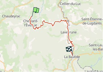
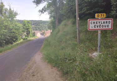
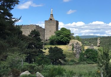
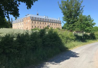
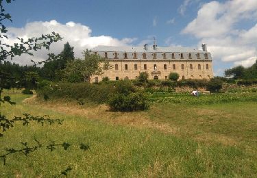
Ruta Senderismo de 24 km a descubrir en Occitania, Lozère, Cheylard-l'Évêque. Esta ruta ha sido propuesta por Nathalie. Mercier.
Descripción
Etape 4
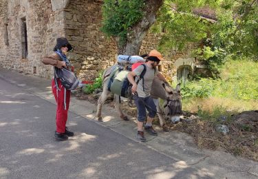
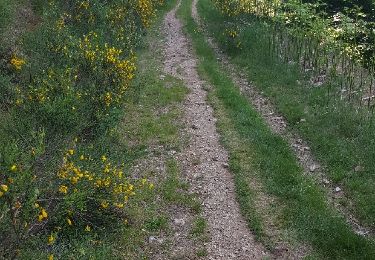
très beau chemin très peu de goudron
2 déviations le 1er causse éboulement, le 2 ème construction d une passerelle
Localización
País:
France
Región :
Occitania
Departamento/provincia :
Lozère
Municipio :
Cheylard-l'Évêque
Localidad:
Unknown
Salida:(Dec)
Salida:(UTM)
564052 ; 4945303 (31T) N.
Comentarios
Excursiones cerca
![Excursión Senderismo Cheylard-l'Évêque - Stevenson etape 5 - Photo](https://media.geolcdn.com/t/375/260/ext.jpg?maxdim=2&url=https%3A%2F%2Fmedia.geolcdn.com%2Ff%2F05f741a3-7cc3-4b5f-a763-6dfc4f0f9283.jpg)
![Senderismo Senderismo](https://static1.geolcdn.com/sitytour/trail-icons/101.png)
Stevenson etape 5
Senderismo
Medio
Cheylard-l'Évêque,
Occitania,
Lozère,
France
![](/images/other/stat-length.png)
16,1 km | 22 km-effort
5h 28min
![](https://static1.geolcdn.com/siteimages/upload/files/16400158638029165_repeat_loop_refresh_sync_direction_icon.png)
No
![Excursión Senderismo Cheylard-l'Évêque - La haute vallee du Langouyrou par Cheylard_l'Eveque - Photo](https://media.geolcdn.com/t/375/260/ext.jpg?maxdim=2&url=https%3A%2F%2Fmedia.geolcdn.com%2Ff%2F53c9d566-ee34-4911-a0b1-e64cb66d44e4.jpg)
![Senderismo Senderismo](https://static1.geolcdn.com/sitytour/trail-icons/101.png)
La haute vallee du Langouyrou par Cheylard_l'Eveque
Senderismo
Medio
Cheylard-l'Évêque,
Occitania,
Lozère,
France
![](/images/other/stat-length.png)
22 km | 29 km-effort
7h 22min
![](https://static1.geolcdn.com/siteimages/upload/files/16400158638029165_repeat_loop_refresh_sync_direction_icon.png)
Sí
![Excursión Senderismo Cheylard-l'Évêque - La Bastide - Photo](https://media.geolcdn.com/t/375/260/ext.jpg?maxdim=2&url=https%3A%2F%2Fmedia.geolcdn.com%2Ff%2F6ece1967-df0f-4873-825b-192ee7a3d973.jpg)
![Senderismo Senderismo](https://static1.geolcdn.com/sitytour/trail-icons/101.png)
La Bastide
Senderismo
Muy difícil
Cheylard-l'Évêque,
Occitania,
Lozère,
France
![](/images/other/stat-length.png)
26 km | 36 km-effort
7h 29min
![](https://static1.geolcdn.com/siteimages/upload/files/16400158638029165_repeat_loop_refresh_sync_direction_icon.png)
No
![Excursión Senderismo Saint-Flour-de-Mercoire - le chélard - Photo](https://media.geolcdn.com/t/375/260/ext.jpg?maxdim=2&url=https%3A%2F%2Fmedia.geolcdn.com%2Ff%2F95b8db69-3dce-47bc-9f31-4efaab872b01.jpg)
![Senderismo Senderismo](https://static1.geolcdn.com/sitytour/trail-icons/101.png)
le chélard
Senderismo
Difícil
Saint-Flour-de-Mercoire,
Occitania,
Lozère,
France
![](/images/other/stat-length.png)
11 km | 14,9 km-effort
3h 6min
![](https://static1.geolcdn.com/siteimages/upload/files/16400158638029165_repeat_loop_refresh_sync_direction_icon.png)
No
![Excursión Senderismo Cheylard-l'Évêque - Le Cheylard la Veyrune - Photo](https://media.geolcdn.com/t/375/260/ext.jpg?maxdim=2&url=https%3A%2F%2Fmedia.geolcdn.com%2Ff%2Fa107f7da-4cef-4d55-b4b1-1743fc7adddd.jpg)
![Senderismo Senderismo](https://static1.geolcdn.com/sitytour/trail-icons/101.png)
Le Cheylard la Veyrune
Senderismo
Difícil
(1)
Cheylard-l'Évêque,
Occitania,
Lozère,
France
![](/images/other/stat-length.png)
16,4 km | 22 km-effort
5h 49min
![](https://static1.geolcdn.com/siteimages/upload/files/16400158638029165_repeat_loop_refresh_sync_direction_icon.png)
No
![Excursión Senderismo Saint-Flour-de-Mercoire - L’Herm Notre dame des neiges - Photo](https://media.geolcdn.com/t/375/260/ext.jpg?maxdim=2&url=https%3A%2F%2Fmedia.geolcdn.com%2Ff%2F1b1c5ae2-25c5-4141-8eeb-1c7365743d8a.jpg)
![Senderismo Senderismo](https://static1.geolcdn.com/sitytour/trail-icons/101.png)
L’Herm Notre dame des neiges
Senderismo
Muy difícil
Saint-Flour-de-Mercoire,
Occitania,
Lozère,
France
![](/images/other/stat-length.png)
34 km | 46 km-effort
8h 51min
![](https://static1.geolcdn.com/siteimages/upload/files/16400158638029165_repeat_loop_refresh_sync_direction_icon.png)
No
![Excursión Bici de montaña Cheylard-l'Évêque - Le Cheylard - Chasseradès - Photo](https://media.geolcdn.com/t/375/260/ext.jpg?maxdim=2&url=https%3A%2F%2Fstatic1.geolcdn.com%2Fsiteimages%2Fupload%2Ffiles%2F1524743154velo.jpg)
![Bici de montaña Bici de montaña](https://static1.geolcdn.com/sitytour/trail-icons/202.png)
Le Cheylard - Chasseradès
Bici de montaña
Muy difícil
(1)
Cheylard-l'Évêque,
Occitania,
Lozère,
France
![](/images/other/stat-length.png)
41 km | 56 km-effort
3h 37min
![](https://static1.geolcdn.com/siteimages/upload/files/16400158638029165_repeat_loop_refresh_sync_direction_icon.png)
No
![Excursión Senderismo Chaudeyrac - Fouzilhac- La Bastide Puylaurent Stevenson - Photo](https://media.geolcdn.com/t/375/260/ext.jpg?maxdim=2&url=https%3A%2F%2Fservices.sitytrail.com%2FGeolivesWS%2FDownloadMedia.ashx%3FTrailID%3D770716%26Media%3Dfix__20170607163620.jpg)
![Senderismo Senderismo](https://static1.geolcdn.com/sitytour/trail-icons/101.png)
Fouzilhac- La Bastide Puylaurent Stevenson
Senderismo
Medio
Chaudeyrac,
Occitania,
Lozère,
France
![](/images/other/stat-length.png)
24 km | 31 km-effort
6h 35min
![](https://static1.geolcdn.com/siteimages/upload/files/16400158638029165_repeat_loop_refresh_sync_direction_icon.png)
No
![Excursión Senderismo Cheylard-l'Évêque - cheylard l'eveque _ Notre Dame des Neiges _ La Bastide saint Laurent - Photo](https://media.geolcdn.com/t/375/260/ext.jpg?maxdim=2&url=https%3A%2F%2Fservices.sitytrail.com%2FGeolivesWS%2FDownloadMedia.ashx%3FTrailID%3D463518%26Media%3Dfix__20150817141929.jpg)
![Senderismo Senderismo](https://static1.geolcdn.com/sitytour/trail-icons/101.png)
cheylard l'eveque _ Notre Dame des Neiges _ La Bastide saint Laurent
Senderismo
Muy fácil
Cheylard-l'Évêque,
Occitania,
Lozère,
France
![](/images/other/stat-length.png)
28 km | 37 km-effort
6h 38min
![](https://static1.geolcdn.com/siteimages/upload/files/16400158638029165_repeat_loop_refresh_sync_direction_icon.png)
No