![](/images/other/stat-length.png)
![Excursión Senderismo Le Beaucet - le Beaucet-Saint Jean - Photo](https://media.geolcdn.com/t/1900/400/ext.pjpeg?maxdim=2&url=https%3A%2F%2Fstatic1.geolcdn.com%2Fsiteimages%2Fupload%2Ffiles%2F1553511878bg_sport_marche.png)
le Beaucet-Saint Jean
micheldutilleul
Usuario
![Longitud](/images/other/stat-length.png)
Longitud
11,9 km
![Altitud máxima](https://static1.geolcdn.com/siteimages/upload/files/1508320355ic_sort_altitude_max_24dp.png)
Altitud máxima
495 m
![Desnivel positivo](https://static1.geolcdn.com/siteimages/upload/files/1508320355ic_sort_den_pos_24dp.png)
Desnivel positivo
444 m
![Km-Effort](/images/other/stat-length.png)
Km-Effort
17,9 km
![Altitud mínima](https://static1.geolcdn.com/siteimages/upload/files/1508320355ic_sort_altitude_min_24dp.png)
Altitud mínima
220 m
![Desnivel negativo](https://static1.geolcdn.com/siteimages/upload/files/1508320355ic_sort_den_neg_24dp.png)
Desnivel negativo
472 m
![Boucle](https://static1.geolcdn.com/siteimages/upload/files/16400158638029165_repeat_loop_refresh_sync_direction_icon.png)
Boucle
No
Fecha de creación :
2023-07-28 08:56:23.653
Última modificación :
2023-08-01 15:52:17.056
![Senderismo](https://static1.geolcdn.com/sitytour/trail-icons/101.png)
3h30
Dificultad : Medio
![Escanee este código QR para abrir la excursión en la aplicación SityTrail](https://capi.geolives.com/qq0zvz2zws4bq2lad0pu/sitytour/trails/3755243/qr.png?size=200)
Aplicación GPS de excursión GRATIS
A propósito
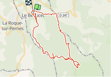
Ruta Senderismo de 11,9 km a descubrir en Provenza-Alpes-Costa Azul, Vaucluse, Le Beaucet. Esta ruta ha sido propuesta por micheldutilleul.
Descripción
Magnifique balade dans les bois, mais très ensoleillée. Pas mal de passages sur les crêtes.
Elle est relativement physique.
Localización
País:
France
Región :
Provenza-Alpes-Costa Azul
Departamento/provincia :
Vaucluse
Municipio :
Le Beaucet
Localidad:
Unknown
Salida:(Dec)
Salida:(UTM)
669946 ; 4872213 (31T) N.
Comentarios
Excursiones cerca
![Excursión Motor La Roque-sur-Pernes - le beaucet - Photo](https://media.geolcdn.com/t/375/260/ext.jpg?maxdim=2&url=https%3A%2F%2Fservices.sitytrail.com%2FGeolivesWS%2FDownloadMedia.ashx%3FTrailID%3D386013%26Media%3D20150213102403.jpg)
![Motor Motor](https://static1.geolcdn.com/sitytour/trail-icons/400.png)
le beaucet
Motor
Fácil
(1)
La Roque-sur-Pernes,
Provenza-Alpes-Costa Azul,
Vaucluse,
France
![](/images/other/stat-length.png)
8,1 km | 10,8 km-effort
2h 52min
![](https://static1.geolcdn.com/siteimages/upload/files/16400158638029165_repeat_loop_refresh_sync_direction_icon.png)
Sí
![Excursión Senderismo Malemort-du-Comtat - malemort de Comtat PR19 - Photo](https://media.geolcdn.com/t/375/260/ext.jpg?maxdim=2&url=https%3A%2F%2Fservices.sitytrail.com%2FGeolivesWS%2FDownloadMedia.ashx%3FTrailID%3D233201%26Media%3D20131028150414.jpg)
![Senderismo Senderismo](https://static1.geolcdn.com/sitytour/trail-icons/101.png)
malemort de Comtat PR19
Senderismo
Fácil
(1)
Malemort-du-Comtat,
Provenza-Alpes-Costa Azul,
Vaucluse,
France
![](/images/other/stat-length.png)
15,9 km | 20 km-effort
3h 53min
![](https://static1.geolcdn.com/siteimages/upload/files/16400158638029165_repeat_loop_refresh_sync_direction_icon.png)
No
![Excursión Senderismo Saumane-de-Vaucluse - Saumane-de-Vaucluse très belle ballade - Photo](https://media.geolcdn.com/t/375/260/f13a2583-4146-473c-8c72-3b4870c42b13.jpg&format=jpg&maxdim=2)
![Senderismo Senderismo](https://static1.geolcdn.com/sitytour/trail-icons/101.png)
Saumane-de-Vaucluse très belle ballade
Senderismo
Medio
(1)
Saumane-de-Vaucluse,
Provenza-Alpes-Costa Azul,
Vaucluse,
France
![](/images/other/stat-length.png)
8,5 km | 13 km-effort
2h 28min
![](https://static1.geolcdn.com/siteimages/upload/files/16400158638029165_repeat_loop_refresh_sync_direction_icon.png)
Sí
![Excursión Senderismo Venasque - Venasque - Photo](https://media.geolcdn.com/t/375/260/ext.jpg?maxdim=2&url=https%3A%2F%2Fservices.sitytrail.com%2FGeolivesWS%2FDownloadMedia.ashx%3FTrailID%3D170316%26Media%3D20130116102457.jpeg)
![Senderismo Senderismo](https://static1.geolcdn.com/sitytour/trail-icons/101.png)
Venasque
Senderismo
Fácil
(3)
Venasque,
Provenza-Alpes-Costa Azul,
Vaucluse,
France
![](/images/other/stat-length.png)
13,1 km | 19,3 km-effort
4h 10min
![](https://static1.geolcdn.com/siteimages/upload/files/16400158638029165_repeat_loop_refresh_sync_direction_icon.png)
Sí
![Excursión Senderismo Malemort-du-Comtat - Traversée Malemort Mormoiron - Photo](https://media.geolcdn.com/t/375/260/b502ffa4-8368-432c-b0e8-bb5f08b803cc.jpg&format=jpg&maxdim=2)
![Senderismo Senderismo](https://static1.geolcdn.com/sitytour/trail-icons/101.png)
Traversée Malemort Mormoiron
Senderismo
Medio
Malemort-du-Comtat,
Provenza-Alpes-Costa Azul,
Vaucluse,
France
![](/images/other/stat-length.png)
13,1 km | 18,1 km-effort
3h 25min
![](https://static1.geolcdn.com/siteimages/upload/files/16400158638029165_repeat_loop_refresh_sync_direction_icon.png)
No
![Excursión Senderismo Saumane-de-Vaucluse - Saumane de Vaucluse / St Gens - Photo](https://media.geolcdn.com/t/375/260/ad5fcb13-12d4-40a2-8637-46a71dbe09db.jpg&format=jpg&maxdim=2)
![Senderismo Senderismo](https://static1.geolcdn.com/sitytour/trail-icons/101.png)
Saumane de Vaucluse / St Gens
Senderismo
Difícil
Saumane-de-Vaucluse,
Provenza-Alpes-Costa Azul,
Vaucluse,
France
![](/images/other/stat-length.png)
20 km | 32 km-effort
6h 1min
![](https://static1.geolcdn.com/siteimages/upload/files/16400158638029165_repeat_loop_refresh_sync_direction_icon.png)
Sí
![Excursión Senderismo Saumane-de-Vaucluse - Saumane de Vaucluse / St Gens - Photo](https://media.geolcdn.com/t/375/260/0c9ad01a-5b0c-44c1-939a-8e6252f252a0.jpg&format=jpg&maxdim=2)
![Senderismo Senderismo](https://static1.geolcdn.com/sitytour/trail-icons/101.png)
Saumane de Vaucluse / St Gens
Senderismo
Medio
Saumane-de-Vaucluse,
Provenza-Alpes-Costa Azul,
Vaucluse,
France
![](/images/other/stat-length.png)
13,1 km | 21 km-effort
4h 25min
![](https://static1.geolcdn.com/siteimages/upload/files/16400158638029165_repeat_loop_refresh_sync_direction_icon.png)
No
![Excursión Senderismo Pernes-les-Fontaines - Pernes les Fontaines - Photo](https://media.geolcdn.com/t/375/260/ext.jpg?maxdim=2&url=https%3A%2F%2Fstatic1.geolcdn.com%2Fsiteimages%2Fupload%2Ffiles%2F1553511878bg_sport_marche.png)
![Senderismo Senderismo](https://static1.geolcdn.com/sitytour/trail-icons/101.png)
Pernes les Fontaines
Senderismo
Fácil
(1)
Pernes-les-Fontaines,
Provenza-Alpes-Costa Azul,
Vaucluse,
France
![](/images/other/stat-length.png)
8 km | 9,7 km-effort
2h 23min
![](https://static1.geolcdn.com/siteimages/upload/files/16400158638029165_repeat_loop_refresh_sync_direction_icon.png)
Sí
![Excursión Senderismo Le Beaucet - autour du Beaucet - Photo](https://media.geolcdn.com/t/375/260/ec7cccd8-5df6-4690-b8ec-e393b98bfb7e.jpg&format=jpg&maxdim=2)
![Senderismo Senderismo](https://static1.geolcdn.com/sitytour/trail-icons/101.png)
autour du Beaucet
Senderismo
Difícil
Le Beaucet,
Provenza-Alpes-Costa Azul,
Vaucluse,
France
![](/images/other/stat-length.png)
12,2 km | 17,5 km-effort
5h 46min
![](https://static1.geolcdn.com/siteimages/upload/files/16400158638029165_repeat_loop_refresh_sync_direction_icon.png)
Sí