![](/images/other/stat-length.png)
![Excursión Bicicleta Vitrolles-en-Luberon - Parcours n°24 - Vitrolles-en-Luberon - Photo](https://media.geolcdn.com/t/1900/400/ext.pjpeg?maxdim=2&url=https%3A%2F%2Fservices.sitytrail.com%2FGeolivesWS%2FDownloadMedia.ashx%3FTrailID%3D375425%26Media%3Df6cdf669-00d3-4069-9c2b-42791339c6d1.jpg)
Parcours n°24 - Vitrolles-en-Luberon
Vélo Loisir Provence
Randonnées de Vélo Loisir Provence GUIDE+
![Longitud](/images/other/stat-length.png)
![Altitud máxima](https://static1.geolcdn.com/siteimages/upload/files/1508320355ic_sort_altitude_max_24dp.png)
![Desnivel positivo](https://static1.geolcdn.com/siteimages/upload/files/1508320355ic_sort_den_pos_24dp.png)
![Km-Effort](/images/other/stat-length.png)
![Altitud mínima](https://static1.geolcdn.com/siteimages/upload/files/1508320355ic_sort_altitude_min_24dp.png)
![Desnivel negativo](https://static1.geolcdn.com/siteimages/upload/files/1508320355ic_sort_den_neg_24dp.png)
![Boucle](https://static1.geolcdn.com/siteimages/upload/files/16400158638029165_repeat_loop_refresh_sync_direction_icon.png)
![Bicicleta](https://static1.geolcdn.com/sitytour/trail-icons/200.png)
2h40
Dificultad : Difícil
![Escanee este código QR para abrir la excursión en la aplicación SityTrail](https://capi.geolives.com/qq0zvz2zws4bq2lad0pu/sitytour/trails/375425/qr.png?size=200)
Aplicación GPS de excursión GRATIS
A propósito
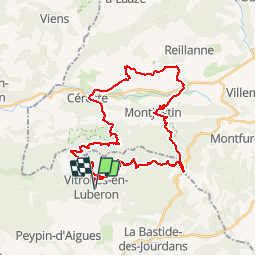
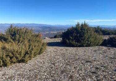
Ruta Bicicleta de 36 km a descubrir en Provenza-Alpes-Costa Azul, Vaucluse, Vitrolles-en-Luberon. Esta ruta ha sido propuesta por Vélo Loisir Provence.
Descripción
You will ride and climb through the col de Vitrolles and discover the hilly landscape of the north and the soothing valley of the Pays d’Aigues. Direction of the itinerary : Vitrolles-en-Luberon => Céreste => Montjustin => Vitrolles-en-Luberon
Localización
Comentarios
Excursiones cerca
![Excursión Bicicleta La Bastide-des-Jourdans - Parcours n°21 - La Bastide-des-Jourdans - Photo](https://media.geolcdn.com/t/375/260/ext.jpg?maxdim=2&url=https%3A%2F%2Fservices.sitytrail.com%2FGeolivesWS%2FDownloadMedia.ashx%3FTrailID%3D375422%26Media%3D1467258b-98e5-4d9c-94cd-785fe12c6f05.jpg)
![Bicicleta Bicicleta](https://static1.geolcdn.com/sitytour/trail-icons/200.png)
Bicicleta
![](/images/other/stat-length.png)
![](https://static1.geolcdn.com/siteimages/upload/files/16400158638029165_repeat_loop_refresh_sync_direction_icon.png)
![Excursión Senderismo Peypin-d'Aigues - peypin d'aygues - Photo](https://media.geolcdn.com/t/375/260/ext.jpg?maxdim=2&url=https%3A%2F%2Fstatic1.geolcdn.com%2Fsiteimages%2Fupload%2Ffiles%2F1553511878bg_sport_marche.png)
![Senderismo Senderismo](https://static1.geolcdn.com/sitytour/trail-icons/101.png)
Senderismo
![](/images/other/stat-length.png)
![](https://static1.geolcdn.com/siteimages/upload/files/16400158638029165_repeat_loop_refresh_sync_direction_icon.png)
![Excursión Senderismo La Bastide-des-Jourdans - Balade autour de la Bastide des Jourdans - Photo](https://media.geolcdn.com/t/375/260/d4cfc590-8e9f-4255-80a4-7ad9e09071c1.jpg&format=jpg&maxdim=2)
![Senderismo Senderismo](https://static1.geolcdn.com/sitytour/trail-icons/101.png)
Senderismo
![](/images/other/stat-length.png)
![](https://static1.geolcdn.com/siteimages/upload/files/16400158638029165_repeat_loop_refresh_sync_direction_icon.png)
![Excursión Senderismo La Bastide-des-Jourdans - Les Collets du Luberon Est - Photo](https://media.geolcdn.com/t/375/260/ext.jpg?maxdim=2&url=https%3A%2F%2Fstatic1.geolcdn.com%2Fsiteimages%2Fupload%2Ffiles%2F1553511878bg_sport_marche.png)
![Senderismo Senderismo](https://static1.geolcdn.com/sitytour/trail-icons/101.png)
Senderismo
![](/images/other/stat-length.png)
![](https://static1.geolcdn.com/siteimages/upload/files/16400158638029165_repeat_loop_refresh_sync_direction_icon.png)
![Excursión Senderismo Peypin-d'Aigues - Peypin-d’Aigues d’Aigues les Dones nord - Photo](https://media.geolcdn.com/t/375/260/fa0bd2de-5f61-4792-be9f-c1323b66629c.jpg&format=jpg&maxdim=2)
![Senderismo Senderismo](https://static1.geolcdn.com/sitytour/trail-icons/101.png)
Senderismo
![](/images/other/stat-length.png)
![](https://static1.geolcdn.com/siteimages/upload/files/16400158638029165_repeat_loop_refresh_sync_direction_icon.png)
![Excursión Senderismo Vitrolles-en-Luberon - Mascas Mourre negre - Photo](https://media.geolcdn.com/t/375/260/ec51df23-2df3-41b4-a86b-282bb2a3d7ef.jpg&format=jpg&maxdim=2)
![Senderismo Senderismo](https://static1.geolcdn.com/sitytour/trail-icons/101.png)
Senderismo
![](/images/other/stat-length.png)
![](https://static1.geolcdn.com/siteimages/upload/files/16400158638029165_repeat_loop_refresh_sync_direction_icon.png)
![Excursión Senderismo La Bastide-des-Jourdans - la bastide des jourdan. - Photo](https://media.geolcdn.com/t/375/260/87f7b02c-aed9-4ecd-a2a8-daef0175ce5e.jpg&format=jpg&maxdim=2)
![Senderismo Senderismo](https://static1.geolcdn.com/sitytour/trail-icons/101.png)
Senderismo
![](/images/other/stat-length.png)
![](https://static1.geolcdn.com/siteimages/upload/files/16400158638029165_repeat_loop_refresh_sync_direction_icon.png)
![Excursión Senderismo Vitrolles-en-Luberon - vitrolles en Lubéron. aire des mascas - Photo](https://media.geolcdn.com/t/375/260/0ccb0f0d-bff8-46ee-add9-4b453c363566.jpg&format=jpg&maxdim=2)
![Senderismo Senderismo](https://static1.geolcdn.com/sitytour/trail-icons/101.png)
Senderismo
![](/images/other/stat-length.png)
![](https://static1.geolcdn.com/siteimages/upload/files/16400158638029165_repeat_loop_refresh_sync_direction_icon.png)
![Excursión Senderismo Céreste - Col des Mascas 84 - Photo](https://media.geolcdn.com/t/375/260/5f8a8e95-e4b9-4f51-b3ee-2dd34976b29d.jpg&format=jpg&maxdim=2)
![Senderismo Senderismo](https://static1.geolcdn.com/sitytour/trail-icons/101.png)
Senderismo
![](/images/other/stat-length.png)
![](https://static1.geolcdn.com/siteimages/upload/files/16400158638029165_repeat_loop_refresh_sync_direction_icon.png)