![](/images/other/stat-length.png)
![Excursión Senderismo Chalais - Vercorin- Crêt du Midi (montée) - Photo](https://media.geolcdn.com/t/1900/400/ext.pjpeg?maxdim=2&url=https%3A%2F%2Fstatic1.geolcdn.com%2Fsiteimages%2Fupload%2Ffiles%2F1553511878bg_sport_marche.png)
Vercorin- Crêt du Midi (montée)
vercorin
Usuario
![Longitud](/images/other/stat-length.png)
Longitud
7,5 km
![Altitud máxima](https://static1.geolcdn.com/siteimages/upload/files/1508320355ic_sort_altitude_max_24dp.png)
Altitud máxima
2321 m
![Desnivel positivo](https://static1.geolcdn.com/siteimages/upload/files/1508320355ic_sort_den_pos_24dp.png)
Desnivel positivo
1007 m
![Km-Effort](/images/other/stat-length.png)
Km-Effort
17,7 km
![Altitud mínima](https://static1.geolcdn.com/siteimages/upload/files/1508320355ic_sort_altitude_min_24dp.png)
Altitud mínima
1334 m
![Desnivel negativo](https://static1.geolcdn.com/siteimages/upload/files/1508320355ic_sort_den_neg_24dp.png)
Desnivel negativo
24 m
![Boucle](https://static1.geolcdn.com/siteimages/upload/files/16400158638029165_repeat_loop_refresh_sync_direction_icon.png)
Boucle
No
Fecha de creación :
2014-12-10 00:00:00.0
Última modificación :
2014-12-10 00:00:00.0
![Senderismo](https://static1.geolcdn.com/sitytour/trail-icons/101.png)
4h14
Dificultad : Desconocido
![Escanee este código QR para abrir la excursión en la aplicación SityTrail](https://capi.geolives.com/qq0zvz2zws4bq2lad0pu/sitytour/trails/37336/qr.png?size=200)
Aplicación GPS de excursión GRATIS
A propósito
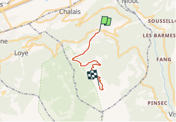
Ruta Senderismo de 7,5 km a descubrir en Vallés, Sierre, Chalais. Esta ruta ha sido propuesta por vercorin.
Descripción
Monter à droite de la Poste par la Route du Bisse, suivre la direction de l''A de Bran, Planards, Cret du Midi, retour en télécabine
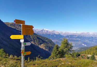
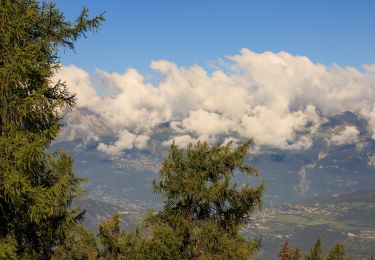
Point fort : magnifique vue sur le Vallon de Réchy
Localización
País:
Switzerland
Región :
Vallés
Departamento/provincia :
Sierre
Municipio :
Chalais
Localidad:
Unknown
Salida:(Dec)
Salida:(UTM)
386651 ; 5123492 (32T) N.
Comentarios
Excursiones cerca
![Excursión A pie Chalais - Les Planards-L'Ar du Tsan - Photo](https://media.geolcdn.com/t/375/260/ext.jpg?maxdim=2&url=https%3A%2F%2Fmedia.geolcdn.com%2Ff%2Fff10f473-0b08-4356-96c2-4fd1a11e5aaa.jpeg)
![A pie A pie](https://static1.geolcdn.com/sitytour/trail-icons/100.png)
Les Planards-L'Ar du Tsan
A pie
Fácil
Chalais,
Vallés,
Sierre,
Switzerland
![](/images/other/stat-length.png)
4,8 km | 6,7 km-effort
1h 31min
![](https://static1.geolcdn.com/siteimages/upload/files/16400158638029165_repeat_loop_refresh_sync_direction_icon.png)
No
![Excursión A pie Chalais - La Lé-refuge du Bisse - Photo](https://media.geolcdn.com/t/375/260/ext.jpg?maxdim=2&url=https%3A%2F%2Fmedia.geolcdn.com%2Ff%2Fa00d1d58-cc60-4765-9e1b-00e885e38196.jpeg)
![A pie A pie](https://static1.geolcdn.com/sitytour/trail-icons/100.png)
La Lé-refuge du Bisse
A pie
Fácil
Chalais,
Vallés,
Sierre,
Switzerland
![](/images/other/stat-length.png)
3,2 km | 5 km-effort
1h 7min
![](https://static1.geolcdn.com/siteimages/upload/files/16400158638029165_repeat_loop_refresh_sync_direction_icon.png)
No
![Excursión Senderismo Crans-Montana - Chemin du Vignoble - Itinéraire dégustation - Photo](https://media.geolcdn.com/t/375/260/ext.jpg?maxdim=2&url=https%3A%2F%2Fservices.sitytrail.com%2FGeolivesWS%2FDownloadMedia.ashx%3FTrailID%3D46260%26Media%3Dimage6.jpg)
![Senderismo Senderismo](https://static1.geolcdn.com/sitytour/trail-icons/101.png)
Chemin du Vignoble - Itinéraire dégustation
Senderismo
Muy fácil
Crans-Montana,
Vallés,
Sierre,
Switzerland
![](/images/other/stat-length.png)
7 km | 10,2 km-effort
2h 45min
![](https://static1.geolcdn.com/siteimages/upload/files/16400158638029165_repeat_loop_refresh_sync_direction_icon.png)
No
![Excursión Senderismo Sierre - Sierre à Chandolin - Photo](https://media.geolcdn.com/t/375/260/ext.jpg?maxdim=2&url=https%3A%2F%2Fstatic1.geolcdn.com%2Fsiteimages%2Fupload%2Ffiles%2F1553511878bg_sport_marche.png)
![Senderismo Senderismo](https://static1.geolcdn.com/sitytour/trail-icons/101.png)
Sierre à Chandolin
Senderismo
Muy fácil
(1)
Sierre,
Vallés,
Sierre,
Switzerland
![](/images/other/stat-length.png)
11,5 km | 28 km-effort
7h 24min
![](https://static1.geolcdn.com/siteimages/upload/files/16400158638029165_repeat_loop_refresh_sync_direction_icon.png)
No
![Excursión Senderismo Chalais - Crêt du Midi - Ar du Tsan- Bisse Vercorin - Photo](https://media.geolcdn.com/t/375/260/ext.jpg?maxdim=2&url=https%3A%2F%2Fstatic1.geolcdn.com%2Fsiteimages%2Fupload%2Ffiles%2F1553511878bg_sport_marche.png)
![Senderismo Senderismo](https://static1.geolcdn.com/sitytour/trail-icons/101.png)
Crêt du Midi - Ar du Tsan- Bisse Vercorin
Senderismo
Muy fácil
(1)
Chalais,
Vallés,
Sierre,
Switzerland
![](/images/other/stat-length.png)
11,4 km | 17 km-effort
3h 46min
![](https://static1.geolcdn.com/siteimages/upload/files/16400158638029165_repeat_loop_refresh_sync_direction_icon.png)
No
![Excursión A pie Grône - Mayens de Réchy-Brie - Photo](https://media.geolcdn.com/t/375/260/ext.jpg?maxdim=2&url=https%3A%2F%2Fstatic1.geolcdn.com%2Fsiteimages%2Fupload%2Ffiles%2F1545311037marcheuse_200dpi.jpg)
![A pie A pie](https://static1.geolcdn.com/sitytour/trail-icons/100.png)
Mayens de Réchy-Brie
A pie
Fácil
Grône,
Vallés,
Sierre,
Switzerland
![](/images/other/stat-length.png)
6,3 km | 11,2 km-effort
2h 32min
![](https://static1.geolcdn.com/siteimages/upload/files/16400158638029165_repeat_loop_refresh_sync_direction_icon.png)
No
![Excursión Senderismo Sierre - Promenade de Finges - Photo](https://media.geolcdn.com/t/375/260/ext.jpg?maxdim=2&url=https%3A%2F%2Fstatic1.geolcdn.com%2Fsiteimages%2Fupload%2Ffiles%2F1553511878bg_sport_marche.png)
![Senderismo Senderismo](https://static1.geolcdn.com/sitytour/trail-icons/101.png)
Promenade de Finges
Senderismo
Muy fácil
Sierre,
Vallés,
Sierre,
Switzerland
![](/images/other/stat-length.png)
8,4 km | 10,4 km-effort
2h 29min
![](https://static1.geolcdn.com/siteimages/upload/files/16400158638029165_repeat_loop_refresh_sync_direction_icon.png)
No
![Excursión Senderismo Crans-Montana - Crans-Montana, Terre de foi - Photo](https://media.geolcdn.com/t/375/260/ext.jpg?maxdim=2&url=https%3A%2F%2Fstatic1.geolcdn.com%2Fsiteimages%2Fupload%2Ffiles%2F1553511878bg_sport_marche.png)
![Senderismo Senderismo](https://static1.geolcdn.com/sitytour/trail-icons/101.png)
Crans-Montana, Terre de foi
Senderismo
Muy fácil
Crans-Montana,
Vallés,
Sierre,
Switzerland
![](/images/other/stat-length.png)
16,4 km | 26 km-effort
8h 0min
![](https://static1.geolcdn.com/siteimages/upload/files/16400158638029165_repeat_loop_refresh_sync_direction_icon.png)
Sí
![Excursión Senderismo Crans-Montana - Montana-Village - Lens - Photo](https://media.geolcdn.com/t/375/260/ext.jpg?maxdim=2&url=https%3A%2F%2Fstatic1.geolcdn.com%2Fsiteimages%2Fupload%2Ffiles%2F1553511878bg_sport_marche.png)
![Senderismo Senderismo](https://static1.geolcdn.com/sitytour/trail-icons/101.png)
Montana-Village - Lens
Senderismo
Muy fácil
Crans-Montana,
Vallés,
Sierre,
Switzerland
![](/images/other/stat-length.png)
4,3 km | 5,1 km-effort
1h 15min
![](https://static1.geolcdn.com/siteimages/upload/files/16400158638029165_repeat_loop_refresh_sync_direction_icon.png)
No