![](/images/other/stat-length.png)
![Excursión Senderismo Coti-Chiavari - Boucle Chez Vero a Coti Chiavari - Photo](https://media.geolcdn.com/t/1900/400/494e0e14-9404-4aac-886b-98f6b239f2ff.jpeg&format=pjpeg&maxdim=2)
Boucle Chez Vero a Coti Chiavari
CooolGeorges
Usuario
![Longitud](/images/other/stat-length.png)
Longitud
5,8 km
![Altitud máxima](https://static1.geolcdn.com/siteimages/upload/files/1508320355ic_sort_altitude_max_24dp.png)
Altitud máxima
539 m
![Desnivel positivo](https://static1.geolcdn.com/siteimages/upload/files/1508320355ic_sort_den_pos_24dp.png)
Desnivel positivo
132 m
![Km-Effort](/images/other/stat-length.png)
Km-Effort
7,5 km
![Altitud mínima](https://static1.geolcdn.com/siteimages/upload/files/1508320355ic_sort_altitude_min_24dp.png)
Altitud mínima
463 m
![Desnivel negativo](https://static1.geolcdn.com/siteimages/upload/files/1508320355ic_sort_den_neg_24dp.png)
Desnivel negativo
132 m
![Boucle](https://static1.geolcdn.com/siteimages/upload/files/16400158638029165_repeat_loop_refresh_sync_direction_icon.png)
Boucle
Sí
Fecha de creación :
2023-05-29 08:34:59.0
Última modificación :
2023-05-29 11:26:22.275
![Senderismo](https://static1.geolcdn.com/sitytour/trail-icons/101.png)
1h46
Dificultad : Medio
![Escanee este código QR para abrir la excursión en la aplicación SityTrail](https://capi.geolives.com/qq0zvz2zws4bq2lad0pu/sitytour/trails/3679335/qr.png?size=200)
Aplicación GPS de excursión GRATIS
A propósito
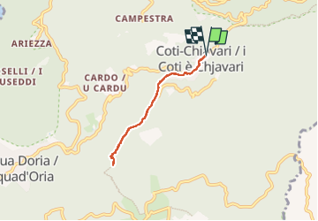
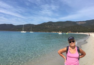
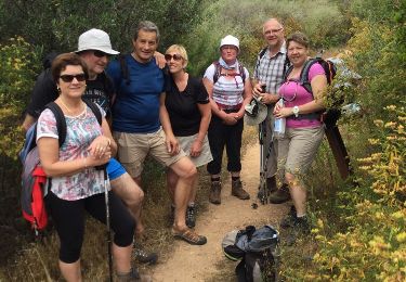
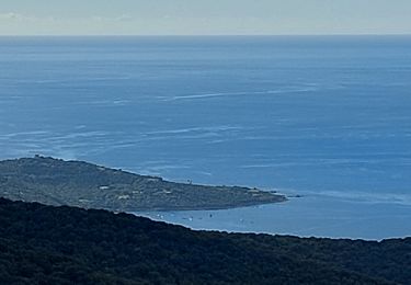
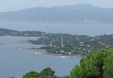
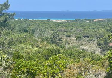
Ruta Senderismo de 5,8 km a descubrir en Córcega, Córcega del Sur, Coti-Chiavari. Esta ruta ha sido propuesta por CooolGeorges.
Descripción
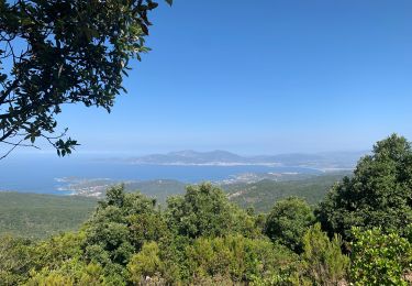
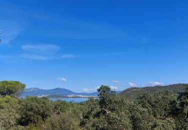
Un aller retour en partant de chez Vero, sur le GR mare e monti pour découvrir une vue magnifique, le maquis et ses fleurs, et déjeuner chez Vero ( réserver ).
Localización
País:
France
Región :
Córcega
Departamento/provincia :
Córcega del Sur
Municipio :
Coti-Chiavari
Localidad:
Unknown
Salida:(Dec)
Salida:(UTM)
481074 ; 4624643 (32T) N.
Comentarios
Excursiones cerca
![Excursión Senderismo Coti-Chiavari - Forêt de Chiavari - Photo](https://media.geolcdn.com/t/375/260/ext.jpg?maxdim=2&url=https%3A%2F%2Fservices.sitytrail.com%2FGeolivesWS%2FDownloadMedia.ashx%3FTrailID%3D102000%26Media%3D2298_1.jpg)
![Senderismo Senderismo](https://static1.geolcdn.com/sitytour/trail-icons/101.png)
Forêt de Chiavari
Senderismo
Difícil
(1)
Coti-Chiavari,
Córcega,
Córcega del Sur,
France
![](/images/other/stat-length.png)
18,6 km | 25 km-effort
3h 30min
![](https://static1.geolcdn.com/siteimages/upload/files/16400158638029165_repeat_loop_refresh_sync_direction_icon.png)
Sí
![Excursión Senderismo Coti-Chiavari - Sentier du Myrthe - Photo](https://media.geolcdn.com/t/375/260/5310b93c-92ec-47ac-a4f5-cb13844f0cae.jpg&format=jpg&maxdim=2)
![Senderismo Senderismo](https://static1.geolcdn.com/sitytour/trail-icons/101.png)
Sentier du Myrthe
Senderismo
Fácil
Coti-Chiavari,
Córcega,
Córcega del Sur,
France
![](/images/other/stat-length.png)
4,5 km | 5,4 km-effort
1h 13min
![](https://static1.geolcdn.com/siteimages/upload/files/16400158638029165_repeat_loop_refresh_sync_direction_icon.png)
Sí
![Excursión Senderismo Pietrosella - Boucle du col de Gradella vers sant’Amanza - Photo](https://media.geolcdn.com/t/375/260/3aeab72e-8111-41ad-8b80-67af378cdac2.jpg&format=jpg&maxdim=2)
![Senderismo Senderismo](https://static1.geolcdn.com/sitytour/trail-icons/101.png)
Boucle du col de Gradella vers sant’Amanza
Senderismo
Difícil
Pietrosella,
Córcega,
Córcega del Sur,
France
![](/images/other/stat-length.png)
11,4 km | 17,6 km-effort
3h 23min
![](https://static1.geolcdn.com/siteimages/upload/files/16400158638029165_repeat_loop_refresh_sync_direction_icon.png)
Sí
![Excursión Senderismo Serra-di-Ferro - Tour de Capannella - Photo](https://media.geolcdn.com/t/375/260/d907a256-fe88-4115-a8df-44c0f4e2ab7f.jpg&format=jpg&maxdim=2)
![Senderismo Senderismo](https://static1.geolcdn.com/sitytour/trail-icons/101.png)
Tour de Capannella
Senderismo
Fácil
Serra-di-Ferro,
Córcega,
Córcega del Sur,
France
![](/images/other/stat-length.png)
6,2 km | 8 km-effort
2h 49min
![](https://static1.geolcdn.com/siteimages/upload/files/16400158638029165_repeat_loop_refresh_sync_direction_icon.png)
Sí
![Excursión Senderismo Coti-Chiavari - porto-pollo - Photo](https://media.geolcdn.com/t/375/260/ext.jpg?maxdim=2&url=https%3A%2F%2Fservices.sitytrail.com%2FGeolivesWS%2FDownloadMedia.ashx%3FTrailID%3D579611%26Media%3D20160603125122.jpg)
![Senderismo Senderismo](https://static1.geolcdn.com/sitytour/trail-icons/101.png)
porto-pollo
Senderismo
Muy fácil
Coti-Chiavari,
Córcega,
Córcega del Sur,
France
![](/images/other/stat-length.png)
14,1 km | 19,7 km-effort
3h 54min
![](https://static1.geolcdn.com/siteimages/upload/files/16400158638029165_repeat_loop_refresh_sync_direction_icon.png)
No
![Excursión Senderismo Pietrosella - rando du pénitencier - Photo](https://media.geolcdn.com/t/375/260/e2768e2a-0a68-40c9-bfa2-80f7cbe66fee.jpg&format=jpg&maxdim=2)
![Senderismo Senderismo](https://static1.geolcdn.com/sitytour/trail-icons/101.png)
rando du pénitencier
Senderismo
Difícil
Pietrosella,
Córcega,
Córcega del Sur,
France
![](/images/other/stat-length.png)
11,7 km | 14,6 km-effort
2h 54min
![](https://static1.geolcdn.com/siteimages/upload/files/16400158638029165_repeat_loop_refresh_sync_direction_icon.png)
No
![Excursión Senderismo Coti-Chiavari - rando des crêtes Coti Chjavari - Photo](https://media.geolcdn.com/t/375/260/1d6d95d5-45c5-4d33-95ca-b852dbed6471.jpg&format=jpg&maxdim=2)
![Senderismo Senderismo](https://static1.geolcdn.com/sitytour/trail-icons/101.png)
rando des crêtes Coti Chjavari
Senderismo
Difícil
Coti-Chiavari,
Córcega,
Córcega del Sur,
France
![](/images/other/stat-length.png)
11,4 km | 15,5 km-effort
3h 8min
![](https://static1.geolcdn.com/siteimages/upload/files/16400158638029165_repeat_loop_refresh_sync_direction_icon.png)
Sí
![Excursión Senderismo Pietrosella - rando maccutello - Photo](https://media.geolcdn.com/t/375/260/68573197-3ae1-4a98-834f-44a577c653c2.jpg&format=jpg&maxdim=2)
![Senderismo Senderismo](https://static1.geolcdn.com/sitytour/trail-icons/101.png)
rando maccutello
Senderismo
Medio
Pietrosella,
Córcega,
Córcega del Sur,
France
![](/images/other/stat-length.png)
8,2 km | 10,8 km-effort
2h 15min
![](https://static1.geolcdn.com/siteimages/upload/files/16400158638029165_repeat_loop_refresh_sync_direction_icon.png)
Sí
![Excursión Senderismo Pietrosella - Boucle dans la forêt domaniale de Chiavari - Photo](https://media.geolcdn.com/t/375/260/eba7d8ae-e57f-4d07-a6d4-9f4ef869c777.jpeg&format=jpg&maxdim=2)
![Senderismo Senderismo](https://static1.geolcdn.com/sitytour/trail-icons/101.png)
Boucle dans la forêt domaniale de Chiavari
Senderismo
Muy fácil
Pietrosella,
Córcega,
Córcega del Sur,
France
![](/images/other/stat-length.png)
5,4 km | 6,5 km-effort
1h 32min
![](https://static1.geolcdn.com/siteimages/upload/files/16400158638029165_repeat_loop_refresh_sync_direction_icon.png)
Sí