![](/images/other/stat-length.png)
![Excursión Senderismo Annecy - 260523 Monr Veyrier - Photo](https://media.geolcdn.com/t/1900/400/7cafe482-fdd0-430f-9583-efd1a36c0573.jpg&format=pjpeg&maxdim=2)
260523 Monr Veyrier
mzonzon05
Usuario
![Longitud](/images/other/stat-length.png)
![Altitud máxima](https://static1.geolcdn.com/siteimages/upload/files/1508320355ic_sort_altitude_max_24dp.png)
![Desnivel positivo](https://static1.geolcdn.com/siteimages/upload/files/1508320355ic_sort_den_pos_24dp.png)
![Km-Effort](/images/other/stat-length.png)
![Altitud mínima](https://static1.geolcdn.com/siteimages/upload/files/1508320355ic_sort_altitude_min_24dp.png)
![Desnivel negativo](https://static1.geolcdn.com/siteimages/upload/files/1508320355ic_sort_den_neg_24dp.png)
![Boucle](https://static1.geolcdn.com/siteimages/upload/files/16400158638029165_repeat_loop_refresh_sync_direction_icon.png)
![Senderismo](https://static1.geolcdn.com/sitytour/trail-icons/101.png)
4h24
Dificultad : Difícil
![Escanee este código QR para abrir la excursión en la aplicación SityTrail](https://capi.geolives.com/qq0zvz2zws4bq2lad0pu/sitytour/trails/3675313/qr.png?size=200)
Aplicación GPS de excursión GRATIS
A propósito
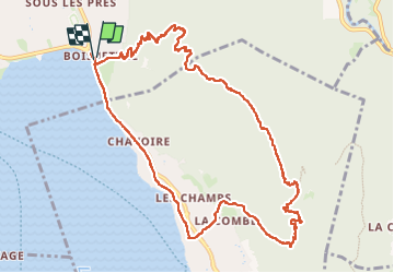
Ruta Senderismo de 12,6 km a descubrir en Auvergne-Rhône-Alpes, Alta Saboya, Annecy. Esta ruta ha sido propuesta por mzonzon05.
Descripción
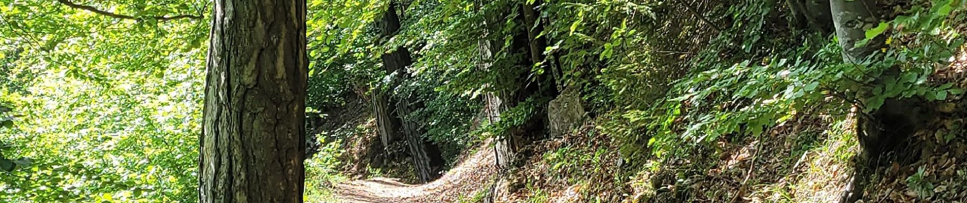
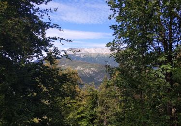
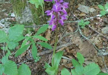
une balade pas facile car ça monte sec puis la redescende nous réconcilie avec nos pieds car elle se fait globalement sur un tapis de feuilles ! Les points de vue sont spectaculaires et le lac et les Bauges à portée de main !
Bien sûr on n'est pas tout seul et toutes les langues sont au RDV, mais tout le monde semble content d'être là.
Localización
Comentarios
Excursiones cerca
![Excursión Senderismo Veyrier-du-Lac - 74 Mt Veyrier 26.06.23 - Photo](https://media.geolcdn.com/t/375/260/e7069dc2-0437-4294-a5ae-f7942e994b91.jpg&format=jpg&maxdim=2)
![Senderismo Senderismo](https://static1.geolcdn.com/sitytour/trail-icons/101.png)
Senderismo
![](/images/other/stat-length.png)
![](https://static1.geolcdn.com/siteimages/upload/files/16400158638029165_repeat_loop_refresh_sync_direction_icon.png)
![Excursión Bici de montaña Annecy - semnoz 31 8 10 - Photo](https://media.geolcdn.com/t/375/260/ext.jpg?maxdim=2&url=https%3A%2F%2Fstatic1.geolcdn.com%2Fsiteimages%2Fupload%2Ffiles%2F1524743154velo.jpg)
![Bici de montaña Bici de montaña](https://static1.geolcdn.com/sitytour/trail-icons/202.png)
Bici de montaña
![](/images/other/stat-length.png)
![](https://static1.geolcdn.com/siteimages/upload/files/16400158638029165_repeat_loop_refresh_sync_direction_icon.png)
![Excursión Bicicleta híbrida Annecy - ANNECY ... le Tour du lac à vélo. - Photo](https://media.geolcdn.com/t/375/260/64c38e9e-432d-4f1e-a098-d3a526529324.jpg&format=jpg&maxdim=2)
![Bicicleta híbrida Bicicleta híbrida](https://static1.geolcdn.com/sitytour/trail-icons/203.png)
Bicicleta híbrida
![](/images/other/stat-length.png)
![](https://static1.geolcdn.com/siteimages/upload/files/16400158638029165_repeat_loop_refresh_sync_direction_icon.png)
![Excursión Senderismo Annecy - ANNECY ... le sentier des crêtes. - Photo](https://media.geolcdn.com/t/375/260/954e85ce-e790-4ec1-8a5b-52762288e410.jpg&format=jpg&maxdim=2)
![Senderismo Senderismo](https://static1.geolcdn.com/sitytour/trail-icons/101.png)
Senderismo
![](/images/other/stat-length.png)
![](https://static1.geolcdn.com/siteimages/upload/files/16400158638029165_repeat_loop_refresh_sync_direction_icon.png)
![Excursión Senderismo Annecy - course avec tobias - Photo](https://media.geolcdn.com/t/375/260/5511a080-8bbf-4e35-a1e7-eb6c019b0144.jpg&format=jpg&maxdim=2)
![Senderismo Senderismo](https://static1.geolcdn.com/sitytour/trail-icons/101.png)
Senderismo
![](/images/other/stat-length.png)
![](https://static1.geolcdn.com/siteimages/upload/files/16400158638029165_repeat_loop_refresh_sync_direction_icon.png)
![Excursión Cicloturismo Veyrier-du-Lac - tour du lac d annecy - Photo](https://media.geolcdn.com/t/375/260/c737b45c-84b1-41e1-b4e0-10680cc8a9ed.jpg&format=jpg&maxdim=2)
![Cicloturismo Cicloturismo](https://static1.geolcdn.com/sitytour/trail-icons/204.png)
Cicloturismo
![](/images/other/stat-length.png)
![](https://static1.geolcdn.com/siteimages/upload/files/16400158638029165_repeat_loop_refresh_sync_direction_icon.png)
![Excursión Senderismo Veyrier-du-Lac - Mont Baret - Photo](https://media.geolcdn.com/t/375/260/204f4d77-91e4-44cb-b334-ef87d103e733.jpg&format=jpg&maxdim=2)
![Senderismo Senderismo](https://static1.geolcdn.com/sitytour/trail-icons/101.png)
Senderismo
![](/images/other/stat-length.png)
![](https://static1.geolcdn.com/siteimages/upload/files/16400158638029165_repeat_loop_refresh_sync_direction_icon.png)
![Excursión Senderismo Annecy - Belvédère mont Baron - Photo](https://media.geolcdn.com/t/375/260/9f969196-bc81-4eef-b145-80c017b0d1a2.jpg&format=jpg&maxdim=2)
![Senderismo Senderismo](https://static1.geolcdn.com/sitytour/trail-icons/101.png)
Senderismo
![](/images/other/stat-length.png)
![](https://static1.geolcdn.com/siteimages/upload/files/16400158638029165_repeat_loop_refresh_sync_direction_icon.png)
![Excursión Senderismo Veyrier-du-Lac - tour du veyrier - Photo](https://media.geolcdn.com/t/375/260/a4b66537-c6f9-4733-a7d4-3e4490b849c0.jpg&format=jpg&maxdim=2)
![Senderismo Senderismo](https://static1.geolcdn.com/sitytour/trail-icons/101.png)
Senderismo
![](/images/other/stat-length.png)
![](https://static1.geolcdn.com/siteimages/upload/files/16400158638029165_repeat_loop_refresh_sync_direction_icon.png)