Vancelle enregistrer SityTrail > Excursiones > Outdoor > Germany > Renania-Palatinado > Landkreis Germersheim > Germersheim SityTrail > Excursiones > Outdoor > Germany > Renania-Palatinado > Landkreis Germersheim > Germersheim Vancelle enregistrer MAD-CVW Usuario 3D © OpenStreetMap contributors Longitud 27 km Altitud máxima 159 m Desnivel positivo 206 m Km-Effort 29 km Altitud mínima 92 m Desnivel negativo 175 m Boucle No Fecha de creación : 2023-04-26 08:08:04.223 Última modificación : 2023-05-22 19:31:44.989 (0 Opinión) Senderismo 633h53 Dificultad : Muy difícil Aplicación GPS de excursión GRATIS SityTrail IGN / Institutos geográficos SityTrail World El mundo es suyo A propósito 
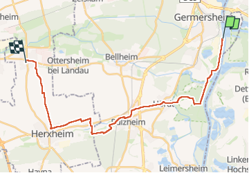
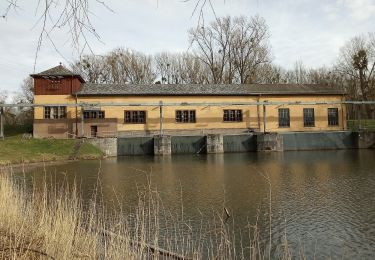
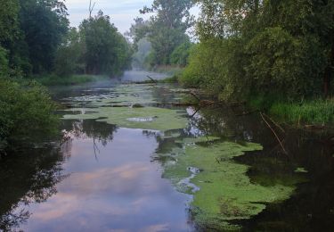
Ruta Senderismo de 27 km a descubrir en Renania-Palatinado, Landkreis Germersheim, Germersheim. Esta ruta ha sido propuesta por MAD-CVW. Leyendas | Más detalles (PDF) Perfil altimétrico Leyendas > 15% 15% - 10% 10% - 5% plano 5% - 10% 10% - 15% 15% - 30% > 30% Localización País: Germany Región : Renania-Palatinado Departamento/provincia : Landkreis Germersheim Municipio : Germersheim Localidad: Unknown Salida:(Dec) 49.20801 / 8.3852367 Salida:(UTM) 455222 ; 5450762 (32U) N. Comentarios Por favor conéctese para dejar un comentario o una evaluación Excursiones cerca GUIDE+ Rheinaue und Hochgestade A pie Fácil Germersheim, Renania-Palatinado, Landkreis Germersheim, Germany 4,8 km | 5,3 km-effort 1h 12min No GUIDE+ Tulpenbaumweg A pie Fácil Hördt, Renania-Palatinado, Landkreis Germersheim, Germany 7,8 km | 8,7 km-effort 1h 58min Sí MAD-CVW Jakobsweg Germersheim-Offenbach Senderismo Muy difícil Germersheim, Renania-Palatinado, Landkreis Germersheim, Germany 27 km | 29 km-effort 5h 25min No