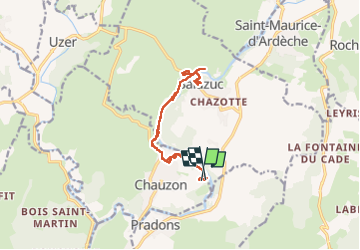
![](/images/other/stat-length.png)
![Excursión Senderismo Chauzon - camping le coin charmant Chauzon à Balazuc - Photo](https://media.geolcdn.com/t/1900/400/9e3472da-95e6-4ca9-9834-4874ef8e1852.jpg&format=pjpeg&maxdim=2)
camping le coin charmant Chauzon à Balazuc
nadd73
Usuario GUIDE
![Longitud](/images/other/stat-length.png)
![Altitud máxima](https://static1.geolcdn.com/siteimages/upload/files/1508320355ic_sort_altitude_max_24dp.png)
![Desnivel positivo](https://static1.geolcdn.com/siteimages/upload/files/1508320355ic_sort_den_pos_24dp.png)
![Km-Effort](/images/other/stat-length.png)
![Altitud mínima](https://static1.geolcdn.com/siteimages/upload/files/1508320355ic_sort_altitude_min_24dp.png)
![Desnivel negativo](https://static1.geolcdn.com/siteimages/upload/files/1508320355ic_sort_den_neg_24dp.png)
![Boucle](https://static1.geolcdn.com/siteimages/upload/files/16400158638029165_repeat_loop_refresh_sync_direction_icon.png)
![Senderismo](https://static1.geolcdn.com/sitytour/trail-icons/101.png)
3h08
Dificultad : Medio
![Escanee este código QR para abrir la excursión en la aplicación SityTrail](https://capi.geolives.com/qq0zvz2zws4bq2lad0pu/sitytour/trails/3656827/qr.png?size=200)
Aplicación GPS de excursión GRATIS
A propósito
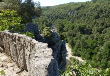
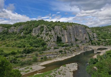
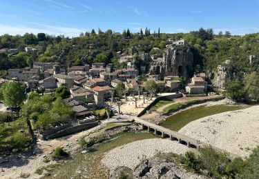
Ruta Senderismo de 13,4 km a descubrir en Auvergne-Rhône-Alpes, Ardecha, Chauzon. Esta ruta ha sido propuesta por nadd73.
Descripción
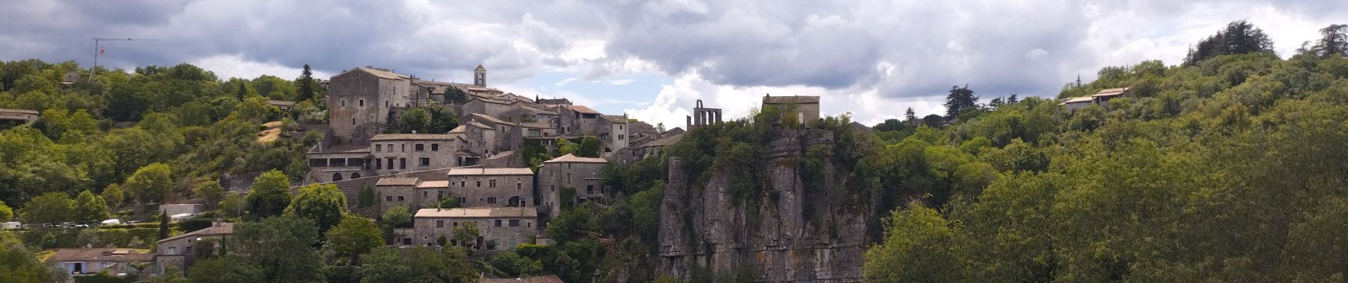
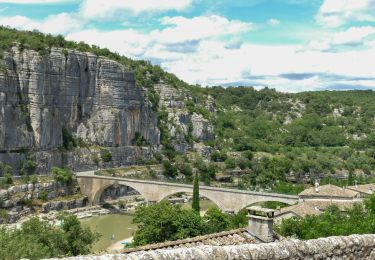
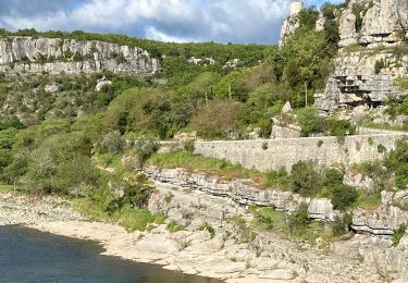
je suis passée au travers de camping car ils ne sont pas ouverts à éviter en pleine saison. Le passage pour arriver à la plage vers Vieil Audon n'est pas marqué sauf quelques marques et ce sont surtout les chèvres qui passent par là donc petit passage et beaucoup de végétations épineuses.
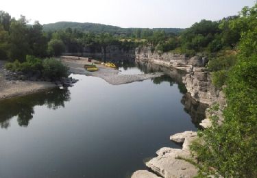
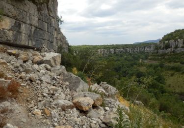
Le passage sur les dalles est déconseillé par temps humide.
Localización
Comentarios
Excursiones cerca
![Excursión Marcha nórdica Lagorce - Lagorce - Photo](https://media.geolcdn.com/t/375/260/ext.jpg?maxdim=2&url=https%3A%2F%2Fservices.sitytrail.com%2FGeolivesWS%2FDownloadMedia.ashx%3FTrailID%3D205821%26Media%3Dfix__20130716082907.jpg)
![Marcha nórdica Marcha nórdica](https://static1.geolcdn.com/sitytour/trail-icons/102.png)
Marcha nórdica
![](/images/other/stat-length.png)
![](https://static1.geolcdn.com/siteimages/upload/files/16400158638029165_repeat_loop_refresh_sync_direction_icon.png)
![Excursión Senderismo Ruoms - Cirque de Gens - Photo](https://media.geolcdn.com/t/375/260/ext.jpg?maxdim=2&url=https%3A%2F%2Fservices.sitytrail.com%2FGeolivesWS%2FDownloadMedia.ashx%3FTrailID%3D204709%26Media%3Dfix__20130714085419.jpg)
![Senderismo Senderismo](https://static1.geolcdn.com/sitytour/trail-icons/101.png)
Senderismo
![](/images/other/stat-length.png)
![](https://static1.geolcdn.com/siteimages/upload/files/16400158638029165_repeat_loop_refresh_sync_direction_icon.png)
![Excursión Senderismo Ruoms - ARDECHES RUOMS Le cirque de gens - Photo](https://media.geolcdn.com/t/375/260/64a1ada7-e196-4279-8acd-3535097ebe03.jpg&format=jpg&maxdim=2)
![Senderismo Senderismo](https://static1.geolcdn.com/sitytour/trail-icons/101.png)
Senderismo
![](/images/other/stat-length.png)
![](https://static1.geolcdn.com/siteimages/upload/files/16400158638029165_repeat_loop_refresh_sync_direction_icon.png)
![Excursión Senderismo Labeaume - Ruoms labeaume Chiapas Figère 15km - Photo](https://media.geolcdn.com/t/375/260/dc1e6df3-300e-487e-a90e-ef693e72da3d.jpg&format=jpg&maxdim=2)
![Senderismo Senderismo](https://static1.geolcdn.com/sitytour/trail-icons/101.png)
Senderismo
![](/images/other/stat-length.png)
![](https://static1.geolcdn.com/siteimages/upload/files/16400158638029165_repeat_loop_refresh_sync_direction_icon.png)
![Excursión Senderismo Pradons - Pradons Gens Abeille 18km - Photo](https://media.geolcdn.com/t/375/260/c0a42803-b9d9-46b0-bff8-8a8a9dfe0f63.jpg&format=jpg&maxdim=2)
![Senderismo Senderismo](https://static1.geolcdn.com/sitytour/trail-icons/101.png)
Senderismo
![](/images/other/stat-length.png)
![](https://static1.geolcdn.com/siteimages/upload/files/16400158638029165_repeat_loop_refresh_sync_direction_icon.png)
![Excursión Senderismo Balazuc - 2024-07-01_17h54m21_Balazuc Cirque de Gens 19km - Photo](https://media.geolcdn.com/t/375/260/6d01c6fd-5949-41a2-b340-daa374c534bc.jpg&format=jpg&maxdim=2)
![Senderismo Senderismo](https://static1.geolcdn.com/sitytour/trail-icons/101.png)
Senderismo
![](/images/other/stat-length.png)
![](https://static1.geolcdn.com/siteimages/upload/files/16400158638029165_repeat_loop_refresh_sync_direction_icon.png)
![Excursión Senderismo Balazuc - Balazuc Servieres Viel-Audon 9km. - Photo](https://media.geolcdn.com/t/375/260/c62c36d0-f3c1-47de-a635-486a1871b8d7.jpg&format=jpg&maxdim=2)
![Senderismo Senderismo](https://static1.geolcdn.com/sitytour/trail-icons/101.png)
Senderismo
![](/images/other/stat-length.png)
![](https://static1.geolcdn.com/siteimages/upload/files/16400158638029165_repeat_loop_refresh_sync_direction_icon.png)
![Excursión sport Balazuc - Balazuc la tour de Jeanne le Viel Audon - Photo](https://media.geolcdn.com/t/375/260/d8c1c8fe-95e6-4adc-b1ae-0d66c200e42e.jpg&format=jpg&maxdim=2)
sport
![](/images/other/stat-length.png)
![](https://static1.geolcdn.com/siteimages/upload/files/16400158638029165_repeat_loop_refresh_sync_direction_icon.png)
![Excursión sport Ruoms - Ruoms, Labeaume - Photo](https://media.geolcdn.com/t/375/260/7d33ddd7-f066-48c9-a760-0327f9148fdd.jpg&format=jpg&maxdim=2)
sport
![](/images/other/stat-length.png)
![](https://static1.geolcdn.com/siteimages/upload/files/16400158638029165_repeat_loop_refresh_sync_direction_icon.png)