![](/images/other/stat-length.png)
![Excursión Senderismo Vignieu - Vignieu - Saint Chef - Canal des moines - Photo](https://media.geolcdn.com/t/1900/400/ext.pjpeg?maxdim=2&url=https%3A%2F%2Fstatic1.geolcdn.com%2Fsiteimages%2Fupload%2Ffiles%2F1553511878bg_sport_marche.png)
Vignieu - Saint Chef - Canal des moines
Ballades lyonnaises
Si l'aventure est dangereuse, essayes la routine : elle est mortelle !
![Longitud](/images/other/stat-length.png)
Longitud
15,6 km
![Altitud máxima](https://static1.geolcdn.com/siteimages/upload/files/1508320355ic_sort_altitude_max_24dp.png)
Altitud máxima
412 m
![Desnivel positivo](https://static1.geolcdn.com/siteimages/upload/files/1508320355ic_sort_den_pos_24dp.png)
Desnivel positivo
339 m
![Km-Effort](/images/other/stat-length.png)
Km-Effort
20 km
![Altitud mínima](https://static1.geolcdn.com/siteimages/upload/files/1508320355ic_sort_altitude_min_24dp.png)
Altitud mínima
237 m
![Desnivel negativo](https://static1.geolcdn.com/siteimages/upload/files/1508320355ic_sort_den_neg_24dp.png)
Desnivel negativo
346 m
![Boucle](https://static1.geolcdn.com/siteimages/upload/files/16400158638029165_repeat_loop_refresh_sync_direction_icon.png)
Boucle
Sí
Fecha de creación :
2023-04-28 08:31:09.935
Última modificación :
2023-04-29 10:59:15.243
![Senderismo](https://static1.geolcdn.com/sitytour/trail-icons/101.png)
4h34
Dificultad : Muy difícil
![Escanee este código QR para abrir la excursión en la aplicación SityTrail](https://capi.geolives.com/qq0zvz2zws4bq2lad0pu/sitytour/trails/3638933/qr.png?size=200)
Aplicación GPS de excursión GRATIS
A propósito
Ruta Senderismo de 15,6 km a descubrir en Auvergne-Rhône-Alpes, Isère, Vignieu. Esta ruta ha sido propuesta por Ballades lyonnaises.
Descripción
Abbatiale St Chef - Fresques Chapelle Haute -Jardin médiéval
Nx Cimetiere (Frederic Dard) Canal des moines
Localización
País:
France
Región :
Auvergne-Rhône-Alpes
Departamento/provincia :
Isère
Municipio :
Vignieu
Localidad:
Unknown
Salida:(Dec)
Salida:(UTM)
688978 ; 5055466 (31T) N.
Comentarios
Excursiones cerca
![Excursión Senderismo La Chapelle-de-la-Tour - Chapelle de la tour - Photo](https://media.geolcdn.com/t/375/260/f47f5711-cb3e-4b5d-bcbd-e1895e4c20f4.jpg&format=jpg&maxdim=2)
![Senderismo Senderismo](https://static1.geolcdn.com/sitytour/trail-icons/101.png)
Chapelle de la tour
Senderismo
Medio
La Chapelle-de-la-Tour,
Auvergne-Rhône-Alpes,
Isère,
France
![](/images/other/stat-length.png)
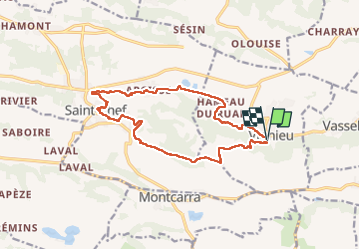
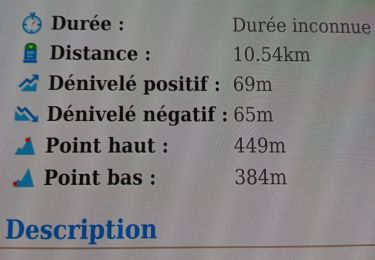
11 km | 12,7 km-effort
2h 53min
![](https://static1.geolcdn.com/siteimages/upload/files/16400158638029165_repeat_loop_refresh_sync_direction_icon.png)
Sí
![Excursión Otra actividad Morestel - randonnée des lavoirs de Vézeronce-Curtin - Photo](https://media.geolcdn.com/t/375/260/ext.jpg?maxdim=2&url=https%3A%2F%2Fservices.sitytrail.com%2FGeolivesWS%2FDownloadMedia.ashx%3FTrailID%3D1085114%26Media%3D20181216105925.jpg)
![Otra actividad Otra actividad](https://static1.geolcdn.com/sitytour/trail-icons/900.png)
randonnée des lavoirs de Vézeronce-Curtin
Otra actividad
Fácil
Morestel,
Auvergne-Rhône-Alpes,
Isère,
France
![](/images/other/stat-length.png)
15,5 km | 18,1 km-effort
3h 28min
![](https://static1.geolcdn.com/siteimages/upload/files/16400158638029165_repeat_loop_refresh_sync_direction_icon.png)
Sí
![Excursión Senderismo Saint-Chef - Randonnée autour de Saint Chef - Photo](https://media.geolcdn.com/t/375/260/ext.jpg?maxdim=2&url=https%3A%2F%2Fservices.sitytrail.com%2FGeolivesWS%2FDownloadMedia.ashx%3FTrailID%3D173262%26Media%3D14880_2.jpg)
![Senderismo Senderismo](https://static1.geolcdn.com/sitytour/trail-icons/101.png)
Randonnée autour de Saint Chef
Senderismo
Fácil
(1)
Saint-Chef,
Auvergne-Rhône-Alpes,
Isère,
France
![](/images/other/stat-length.png)
10,3 km | 12,4 km-effort
3h 45min
![](https://static1.geolcdn.com/siteimages/upload/files/16400158638029165_repeat_loop_refresh_sync_direction_icon.png)
Sí
![Excursión Senderismo Saint-Chef - Saint chef 2 - Photo](https://media.geolcdn.com/t/375/260/ext.jpg?maxdim=2&url=https%3A%2F%2Fstatic1.geolcdn.com%2Fsiteimages%2Fupload%2Ffiles%2F1553511878bg_sport_marche.png)
![Senderismo Senderismo](https://static1.geolcdn.com/sitytour/trail-icons/101.png)
Saint chef 2
Senderismo
Muy fácil
(1)
Saint-Chef,
Auvergne-Rhône-Alpes,
Isère,
France
![](/images/other/stat-length.png)
9,6 km | 12,5 km-effort
3h 3min
![](https://static1.geolcdn.com/siteimages/upload/files/16400158638029165_repeat_loop_refresh_sync_direction_icon.png)
Sí
![Excursión Senderismo Vézeronce-Curtin - Vignieu - Photo](https://media.geolcdn.com/t/375/260/ext.jpg?maxdim=2&url=https%3A%2F%2Fstatic1.geolcdn.com%2Fsiteimages%2Fupload%2Ffiles%2F1553511878bg_sport_marche.png)
![Senderismo Senderismo](https://static1.geolcdn.com/sitytour/trail-icons/101.png)
Vignieu
Senderismo
Medio
Vézeronce-Curtin,
Auvergne-Rhône-Alpes,
Isère,
France
![](/images/other/stat-length.png)
11,7 km | 15,4 km-effort
3h 18min
![](https://static1.geolcdn.com/siteimages/upload/files/16400158638029165_repeat_loop_refresh_sync_direction_icon.png)
Sí
![Excursión Bicicleta Vézeronce-Curtin - de vezeronce-curtin à la via rhona - Photo](https://media.geolcdn.com/t/375/260/ext.jpg?maxdim=2&url=https%3A%2F%2Fstatic1.geolcdn.com%2Fsiteimages%2Fupload%2Ffiles%2F1524743154velo.jpg)
![Bicicleta Bicicleta](https://static1.geolcdn.com/sitytour/trail-icons/200.png)
de vezeronce-curtin à la via rhona
Bicicleta
Fácil
Vézeronce-Curtin,
Auvergne-Rhône-Alpes,
Isère,
France
![](/images/other/stat-length.png)
32 km | 35 km-effort
2h 14min
![](https://static1.geolcdn.com/siteimages/upload/files/16400158638029165_repeat_loop_refresh_sync_direction_icon.png)
Sí
![Excursión Senderismo Ruy-Montceau - Rando GODAS 12 km juin 2013 - Photo](https://media.geolcdn.com/t/375/260/ext.jpg?maxdim=2&url=https%3A%2F%2Fstatic1.geolcdn.com%2Fsiteimages%2Fupload%2Ffiles%2F1553511878bg_sport_marche.png)
![Senderismo Senderismo](https://static1.geolcdn.com/sitytour/trail-icons/101.png)
Rando GODAS 12 km juin 2013
Senderismo
Medio
Ruy-Montceau,
Auvergne-Rhône-Alpes,
Isère,
France
![](/images/other/stat-length.png)
11,9 km | 15 km-effort
3h 11min
![](https://static1.geolcdn.com/siteimages/upload/files/16400158638029165_repeat_loop_refresh_sync_direction_icon.png)
Sí
![Excursión Senderismo Montcarra - Sur les hauteurs de Montcarra - Photo](https://media.geolcdn.com/t/375/260/ext.jpg?maxdim=2&url=https%3A%2F%2Fstatic1.geolcdn.com%2Fsiteimages%2Fupload%2Ffiles%2F1553511878bg_sport_marche.png)
![Senderismo Senderismo](https://static1.geolcdn.com/sitytour/trail-icons/101.png)
Sur les hauteurs de Montcarra
Senderismo
Fácil
(1)
Montcarra,
Auvergne-Rhône-Alpes,
Isère,
France
![](/images/other/stat-length.png)
6,8 km | 8 km-effort
1h 44min
![](https://static1.geolcdn.com/siteimages/upload/files/16400158638029165_repeat_loop_refresh_sync_direction_icon.png)
Sí
![Excursión Senderismo Vézeronce-Curtin - vezeronce-14kms - Photo](https://media.geolcdn.com/t/375/260/ext.jpg?maxdim=2&url=https%3A%2F%2Fstatic1.geolcdn.com%2Fsiteimages%2Fupload%2Ffiles%2F1553511878bg_sport_marche.png)
![Senderismo Senderismo](https://static1.geolcdn.com/sitytour/trail-icons/101.png)
vezeronce-14kms
Senderismo
Difícil
Vézeronce-Curtin,
Auvergne-Rhône-Alpes,
Isère,
France
![](/images/other/stat-length.png)
14,1 km | 16,5 km-effort
3h 44min
![](https://static1.geolcdn.com/siteimages/upload/files/16400158638029165_repeat_loop_refresh_sync_direction_icon.png)
Sí