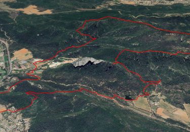
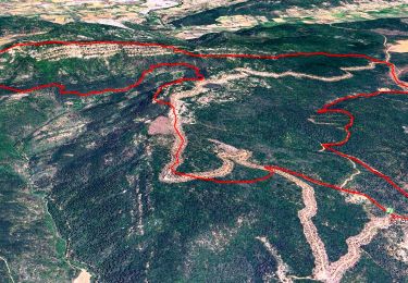
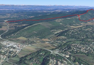
![](/images/other/stat-length.png)
![Excursión Senderismo Brignoles - l'Amarron - Photo](https://media.geolcdn.com/t/1900/400/9224daff-cf2d-4732-bd80-bafe4a1696c0.jpg&format=pjpeg&maxdim=2)
l'Amarron
FSantoni
Usuario
![Longitud](/images/other/stat-length.png)
![Altitud máxima](https://static1.geolcdn.com/siteimages/upload/files/1508320355ic_sort_altitude_max_24dp.png)
![Desnivel positivo](https://static1.geolcdn.com/siteimages/upload/files/1508320355ic_sort_den_pos_24dp.png)
![Km-Effort](/images/other/stat-length.png)
![Altitud mínima](https://static1.geolcdn.com/siteimages/upload/files/1508320355ic_sort_altitude_min_24dp.png)
![Desnivel negativo](https://static1.geolcdn.com/siteimages/upload/files/1508320355ic_sort_den_neg_24dp.png)
![Boucle](https://static1.geolcdn.com/siteimages/upload/files/16400158638029165_repeat_loop_refresh_sync_direction_icon.png)
![Senderismo](https://static1.geolcdn.com/sitytour/trail-icons/101.png)
6h38
Dificultad : Difícil
![Escanee este código QR para abrir la excursión en la aplicación SityTrail](https://capi.geolives.com/qq0zvz2zws4bq2lad0pu/sitytour/trails/3616159/qr.png?size=200)
Aplicación GPS de excursión GRATIS
A propósito
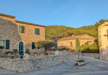
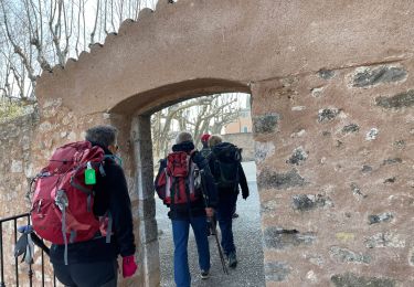
Ruta Senderismo de 8,7 km a descubrir en Provenza-Alpes-Costa Azul, Var, Brignoles. Esta ruta ha sido propuesta por FSantoni.
Descripción
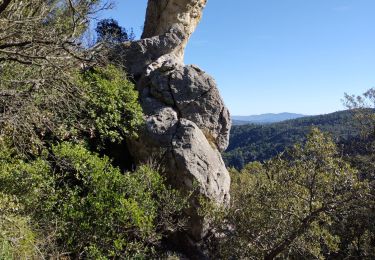
Montée plutôt pentue, mais globalement agréable, avec au sommet un magnifique point de vue.
La descente est moins sympa car visiblement le chemin est peu usité, donc pas toujours visible (on s'est dailleurs égarés 2 fois !), et assez dangereux par la nature du sol et les nombreux ravinements, avec cependant de très beaux paysages minéraux.
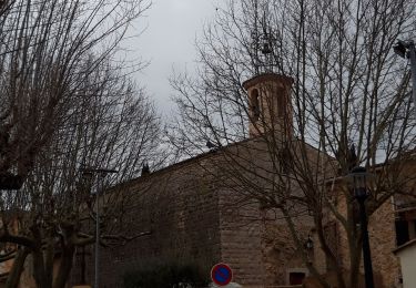
Localización
Comentarios
Excursiones cerca
![Excursión Senderismo La Celle - Trace_La_Celle - Photo](https://media.geolcdn.com/t/375/260/367c307f-f133-49ff-990b-24c0026569ab.jpg&format=jpg&maxdim=2)
![Senderismo Senderismo](https://static1.geolcdn.com/sitytour/trail-icons/101.png)
Senderismo
![](/images/other/stat-length.png)
![](https://static1.geolcdn.com/siteimages/upload/files/16400158638029165_repeat_loop_refresh_sync_direction_icon.png)
![Excursión Senderismo La Celle - L'Escarelle 1 - Photo](https://media.geolcdn.com/t/375/260/ext.jpg?maxdim=2&url=https%3A%2F%2Fstatic1.geolcdn.com%2Fsiteimages%2Fupload%2Ffiles%2F1553511878bg_sport_marche.png)
![Senderismo Senderismo](https://static1.geolcdn.com/sitytour/trail-icons/101.png)
Senderismo
![](/images/other/stat-length.png)
![](https://static1.geolcdn.com/siteimages/upload/files/16400158638029165_repeat_loop_refresh_sync_direction_icon.png)
![Excursión Senderismo Camps-la-Source - Rocher du Gueit- Camps la Source-06-11-2024 - Photo](https://media.geolcdn.com/t/375/260/e92a19e7-d25b-4cc7-a41e-f3e4999745e6.jpg&format=jpg&maxdim=2)
![Senderismo Senderismo](https://static1.geolcdn.com/sitytour/trail-icons/101.png)
Senderismo
![](/images/other/stat-length.png)
![](https://static1.geolcdn.com/siteimages/upload/files/16400158638029165_repeat_loop_refresh_sync_direction_icon.png)
![Excursión Senderismo La Celle - Roc de Candelon - Photo](https://media.geolcdn.com/t/375/260/a9cfb2ad-a53d-4040-a9b9-a70f08f9f434.jpg&format=jpg&maxdim=2)
![Senderismo Senderismo](https://static1.geolcdn.com/sitytour/trail-icons/101.png)
Senderismo
![](/images/other/stat-length.png)
![](https://static1.geolcdn.com/siteimages/upload/files/16400158638029165_repeat_loop_refresh_sync_direction_icon.png)
![Excursión Senderismo La Roquebrussanne - chapelle St André et grotte des irris - Photo](https://media.geolcdn.com/t/375/260/c17b726b-2dcc-44be-a87c-f260edf4e94a.jpg&format=jpg&maxdim=2)
![Senderismo Senderismo](https://static1.geolcdn.com/sitytour/trail-icons/101.png)
Senderismo
![](/images/other/stat-length.png)
![](https://static1.geolcdn.com/siteimages/upload/files/16400158638029165_repeat_loop_refresh_sync_direction_icon.png)
![Excursión Senderismo Garéoult - L'Amarron depuis Garéoult - Photo](https://media.geolcdn.com/t/375/260/47c5c3b8-59ea-460f-b034-de18890572e7.jpg&format=jpg&maxdim=2)
![Senderismo Senderismo](https://static1.geolcdn.com/sitytour/trail-icons/101.png)
Senderismo
![](/images/other/stat-length.png)
![](https://static1.geolcdn.com/siteimages/upload/files/16400158638029165_repeat_loop_refresh_sync_direction_icon.png)
![Excursión Senderismo Camps-la-Source - Barres de St Quinis par Camps la Source - Photo](https://media.geolcdn.com/t/375/260/350601e3-1f72-40c6-8d5a-a3df47012346.jpg&format=jpg&maxdim=2)
![Senderismo Senderismo](https://static1.geolcdn.com/sitytour/trail-icons/101.png)
Senderismo
![](/images/other/stat-length.png)
![](https://static1.geolcdn.com/siteimages/upload/files/16400158638029165_repeat_loop_refresh_sync_direction_icon.png)
![Excursión Senderismo La Celle - Celle : la Loube et l'Amarron - Photo](https://media.geolcdn.com/t/375/260/c913ba8d-bcb8-4648-a445-1dd1f4815812.jpg&format=jpg&maxdim=2)
![Senderismo Senderismo](https://static1.geolcdn.com/sitytour/trail-icons/101.png)
Senderismo
![](/images/other/stat-length.png)
![](https://static1.geolcdn.com/siteimages/upload/files/16400158638029165_repeat_loop_refresh_sync_direction_icon.png)
![Excursión Senderismo La Celle - La Celle-19-02-21 - Photo](https://media.geolcdn.com/t/375/260/8fcb5456-c13d-4ae0-a903-c2fb80e2afa9.jpg&format=jpg&maxdim=2)
![Senderismo Senderismo](https://static1.geolcdn.com/sitytour/trail-icons/101.png)
Senderismo
![](/images/other/stat-length.png)
![](https://static1.geolcdn.com/siteimages/upload/files/16400158638029165_repeat_loop_refresh_sync_direction_icon.png)