![](/images/other/stat-length.png)
![Excursión Senderismo Espeluche - Espeluche chateau de rochefort - Photo](https://media.geolcdn.com/t/1900/400/ext.pjpeg?maxdim=2&url=https%3A%2F%2Fstatic1.geolcdn.com%2Fsiteimages%2Fupload%2Ffiles%2F1553511878bg_sport_marche.png)
Espeluche chateau de rochefort
Danielle07
Usuario
![Longitud](/images/other/stat-length.png)
Longitud
17,2 km
![Altitud máxima](https://static1.geolcdn.com/siteimages/upload/files/1508320355ic_sort_altitude_max_24dp.png)
Altitud máxima
410 m
![Desnivel positivo](https://static1.geolcdn.com/siteimages/upload/files/1508320355ic_sort_den_pos_24dp.png)
Desnivel positivo
455 m
![Km-Effort](/images/other/stat-length.png)
Km-Effort
23 km
![Altitud mínima](https://static1.geolcdn.com/siteimages/upload/files/1508320355ic_sort_altitude_min_24dp.png)
Altitud mínima
160 m
![Desnivel negativo](https://static1.geolcdn.com/siteimages/upload/files/1508320355ic_sort_den_neg_24dp.png)
Desnivel negativo
454 m
![Boucle](https://static1.geolcdn.com/siteimages/upload/files/16400158638029165_repeat_loop_refresh_sync_direction_icon.png)
Boucle
Sí
Fecha de creación :
2023-04-02 07:30:39.101
Última modificación :
2025-01-18 15:11:15.928
![Senderismo](https://static1.geolcdn.com/sitytour/trail-icons/101.png)
5h17
Dificultad : Medio
![Escanee este código QR para abrir la excursión en la aplicación SityTrail](https://capi.geolives.com/qq0zvz2zws4bq2lad0pu/sitytour/trails/3606551/qr.png?size=200)
Aplicación GPS de excursión GRATIS
A propósito
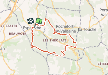
Ruta Senderismo de 17,2 km a descubrir en Auvergne-Rhône-Alpes, Drôme, Espeluche. Esta ruta ha sido propuesta por Danielle07.
Descripción
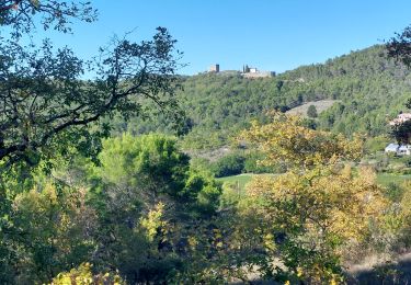
tracé en évitant le plus possible de piste, passage au très beau château de Rochefort en Valdaine, visite de village médiéval d'Espeluche
Parling au stade
Localización
País:
France
Región :
Auvergne-Rhône-Alpes
Departamento/provincia :
Drôme
Municipio :
Espeluche
Localidad:
Unknown
Salida:(Dec)
Salida:(UTM)
645154 ; 4930847 (31T) N.
Comentarios
Excursiones cerca
![Excursión Senderismo Espeluche - 2022-10-20_15h14m37_GPX-Bois-Jamot-Espeluche - Photo](https://media.geolcdn.com/t/375/260/799cda92-0993-44e5-bfc9-d42f9f871bf2.jpg&format=jpg&maxdim=2)
![Senderismo Senderismo](https://static1.geolcdn.com/sitytour/trail-icons/101.png)
2022-10-20_15h14m37_GPX-Bois-Jamot-Espeluche
Senderismo
Medio
(1)
Espeluche,
Auvergne-Rhône-Alpes,
Drôme,
France
![](/images/other/stat-length.png)
11,3 km | 15,4 km-effort
3h 28min
![](https://static1.geolcdn.com/siteimages/upload/files/16400158638029165_repeat_loop_refresh_sync_direction_icon.png)
Sí
![Excursión Senderismo Rochefort-en-Valdaine - Rochefort-en-Valdaine Le Janeston 7km5 - Photo](https://media.geolcdn.com/t/375/260/c37954dd-2a13-465c-a79c-9622f5a3d882.jpg&format=jpg&maxdim=2)
![Senderismo Senderismo](https://static1.geolcdn.com/sitytour/trail-icons/101.png)
Rochefort-en-Valdaine Le Janeston 7km5
Senderismo
Medio
(1)
Rochefort-en-Valdaine,
Auvergne-Rhône-Alpes,
Drôme,
France
![](/images/other/stat-length.png)
7,3 km | 10,3 km-effort
2h 23min
![](https://static1.geolcdn.com/siteimages/upload/files/16400158638029165_repeat_loop_refresh_sync_direction_icon.png)
Sí
![Excursión Senderismo Allan - allan transclavienne rac - Photo](https://media.geolcdn.com/t/375/260/ext.jpg?maxdim=2&url=https%3A%2F%2Fservices.sitytrail.com%2FGeolivesWS%2FDownloadMedia.ashx%3FTrailID%3D649381%26Media%3Dfix__20161022171755.jpg)
![Senderismo Senderismo](https://static1.geolcdn.com/sitytour/trail-icons/101.png)
allan transclavienne rac
Senderismo
Muy fácil
(1)
Allan,
Auvergne-Rhône-Alpes,
Drôme,
France
![](/images/other/stat-length.png)
19,1 km | 26 km-effort
5h 11min
![](https://static1.geolcdn.com/siteimages/upload/files/16400158638029165_repeat_loop_refresh_sync_direction_icon.png)
Sí
![Excursión Senderismo La Touche - La Touche Crêtes de l'ysard 12km. - Photo](https://media.geolcdn.com/t/375/260/b7717e93-9def-4e5d-8328-3e96528d5925.jpg&format=jpg&maxdim=2)
![Senderismo Senderismo](https://static1.geolcdn.com/sitytour/trail-icons/101.png)
La Touche Crêtes de l'ysard 12km.
Senderismo
Difícil
(1)
La Touche,
Auvergne-Rhône-Alpes,
Drôme,
France
![](/images/other/stat-length.png)
12,1 km | 16,8 km-effort
3h 48min
![](https://static1.geolcdn.com/siteimages/upload/files/16400158638029165_repeat_loop_refresh_sync_direction_icon.png)
Sí
![Excursión Bici de montaña Puygiron - Puygiron VTT n°5 - Photo](https://media.geolcdn.com/t/375/260/ext.jpg?maxdim=2&url=https%3A%2F%2Fservices.sitytrail.com%2FGeolivesWS%2FDownloadMedia.ashx%3FTrailID%3D104845%26Media%3D8346_2.jpg)
![Bici de montaña Bici de montaña](https://static1.geolcdn.com/sitytour/trail-icons/202.png)
Puygiron VTT n°5
Bici de montaña
Muy difícil
(1)
Puygiron,
Auvergne-Rhône-Alpes,
Drôme,
France
![](/images/other/stat-length.png)
47 km | 60 km-effort
3h 0min
![](https://static1.geolcdn.com/siteimages/upload/files/16400158638029165_repeat_loop_refresh_sync_direction_icon.png)
Sí
![Excursión Senderismo La Touche - La Touche : Les Citelles et Serre Pointu 12km - Photo](https://media.geolcdn.com/t/375/260/6be75cc0-9945-4cf3-b3f9-69a08db1d316.jpg&format=jpg&maxdim=2)
![Senderismo Senderismo](https://static1.geolcdn.com/sitytour/trail-icons/101.png)
La Touche : Les Citelles et Serre Pointu 12km
Senderismo
Difícil
La Touche,
Auvergne-Rhône-Alpes,
Drôme,
France
![](/images/other/stat-length.png)
12 km | 16,6 km-effort
4h 3min
![](https://static1.geolcdn.com/siteimages/upload/files/16400158638029165_repeat_loop_refresh_sync_direction_icon.png)
Sí
![Excursión Senderismo La Touche - La Touche Mastaize 9km - Photo](https://media.geolcdn.com/t/375/260/7617f59d-4270-4583-9eab-9f2081c0076a.jpg&format=jpg&maxdim=2)
![Senderismo Senderismo](https://static1.geolcdn.com/sitytour/trail-icons/101.png)
La Touche Mastaize 9km
Senderismo
Difícil
La Touche,
Auvergne-Rhône-Alpes,
Drôme,
France
![](/images/other/stat-length.png)
8,6 km | 10,7 km-effort
3h 24min
![](https://static1.geolcdn.com/siteimages/upload/files/16400158638029165_repeat_loop_refresh_sync_direction_icon.png)
Sí
![Senderismo Senderismo](https://static1.geolcdn.com/sitytour/trail-icons/101.png)
2022-10-10_11h21m09_tmpWriteApidae_259847_fr
Senderismo
Medio
Allan,
Auvergne-Rhône-Alpes,
Drôme,
France
![](/images/other/stat-length.png)
10,7 km | 15,2 km-effort
3h 27min
![](https://static1.geolcdn.com/siteimages/upload/files/16400158638029165_repeat_loop_refresh_sync_direction_icon.png)
Sí
![Excursión Senderismo Espeluche - 2022-10-10_11h19m57_9875258 - Photo](https://media.geolcdn.com/t/375/260/7d9cd8c2-7377-40ec-9100-181655b047cd.jpg&format=jpg&maxdim=2)
![Senderismo Senderismo](https://static1.geolcdn.com/sitytour/trail-icons/101.png)
2022-10-10_11h19m57_9875258
Senderismo
Medio
Espeluche,
Auvergne-Rhône-Alpes,
Drôme,
France
![](/images/other/stat-length.png)
8 km | 10,2 km-effort
2h 9min
![](https://static1.geolcdn.com/siteimages/upload/files/16400158638029165_repeat_loop_refresh_sync_direction_icon.png)
Sí