![](/images/other/stat-length.png)
![Excursión Senderismo Saint-Étienne-lès-Remiremont - Vers la Tête des Cuveaux - Photo](https://media.geolcdn.com/t/1900/400/ext.pjpeg?maxdim=2&url=https%3A%2F%2Fservices.sitytrail.com%2FGeolivesWS%2FDownloadMedia.ashx%3FTrailID%3D360089%26Media%3Dfix__20141104160926.jpg)
Vers la Tête des Cuveaux
jeanclaude12
Usuario
![Longitud](/images/other/stat-length.png)
Longitud
9 km
![Altitud máxima](https://static1.geolcdn.com/siteimages/upload/files/1508320355ic_sort_altitude_max_24dp.png)
Altitud máxima
788 m
![Desnivel positivo](https://static1.geolcdn.com/siteimages/upload/files/1508320355ic_sort_den_pos_24dp.png)
Desnivel positivo
256 m
![Km-Effort](/images/other/stat-length.png)
Km-Effort
12,4 km
![Altitud mínima](https://static1.geolcdn.com/siteimages/upload/files/1508320355ic_sort_altitude_min_24dp.png)
Altitud mínima
653 m
![Desnivel negativo](https://static1.geolcdn.com/siteimages/upload/files/1508320355ic_sort_den_neg_24dp.png)
Desnivel negativo
257 m
![Boucle](https://static1.geolcdn.com/siteimages/upload/files/16400158638029165_repeat_loop_refresh_sync_direction_icon.png)
Boucle
Sí
Fecha de creación :
2014-12-10 00:00:00.0
Última modificación :
2014-12-10 00:00:00.0
![Senderismo](https://static1.geolcdn.com/sitytour/trail-icons/101.png)
2h30
Dificultad : Fácil
![Escanee este código QR para abrir la excursión en la aplicación SityTrail](https://capi.geolives.com/qq0zvz2zws4bq2lad0pu/sitytour/trails/360089/qr.png?size=200)
Aplicación GPS de excursión GRATIS
A propósito
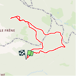
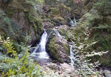
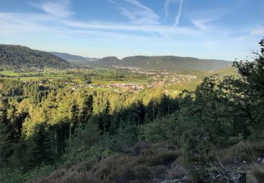
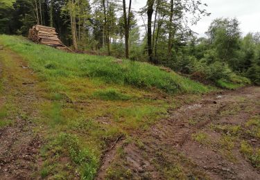
Ruta Senderismo de 9 km a descubrir en Gran Este, Vosgos, Saint-Étienne-lès-Remiremont. Esta ruta ha sido propuesta por jeanclaude12.
Descripción
Partir du Haut des Viaux vers la Croix de Groshaut et la Tête des Cuveaux et revenir vers le Col du Singe en contournant le Moury puis s'arrêter aux Roches des Champs Dolents.
Localización
País:
France
Región :
Gran Este
Departamento/provincia :
Vosgos
Municipio :
Saint-Étienne-lès-Remiremont
Localidad:
Unknown
Salida:(Dec)
Salida:(UTM)
324280 ; 5327470 (32U) N.
Comentarios
Excursiones cerca
![Excursión Senderismo Tendon - Cascades de Tendon - Trou de l'Enfer - Roches de la Moulure - Photo](https://media.geolcdn.com/t/375/260/6cb30f79-01f0-4a87-b35f-5f5af3475353.jpg&format=jpg&maxdim=2)
![Senderismo Senderismo](https://static1.geolcdn.com/sitytour/trail-icons/101.png)
Cascades de Tendon - Trou de l'Enfer - Roches de la Moulure
Senderismo
Medio
(4)
Tendon,
Gran Este,
Vosgos,
France
![](/images/other/stat-length.png)
20 km | 28 km-effort
5h 33min
![](https://static1.geolcdn.com/siteimages/upload/files/16400158638029165_repeat_loop_refresh_sync_direction_icon.png)
Sí
![Excursión Senderismo Éloyes - eloyes champ dolant - Photo](https://media.geolcdn.com/t/375/260/8221c7ad-810e-48e5-9b79-c276aa574b68.jpg&format=jpg&maxdim=2)
![Senderismo Senderismo](https://static1.geolcdn.com/sitytour/trail-icons/101.png)
eloyes champ dolant
Senderismo
Medio
(3)
Éloyes,
Gran Este,
Vosgos,
France
![](/images/other/stat-length.png)
8,2 km | 12,4 km-effort
2h 26min
![](https://static1.geolcdn.com/siteimages/upload/files/16400158638029165_repeat_loop_refresh_sync_direction_icon.png)
Sí
![Excursión Senderismo Le Tholy - tendon - Photo](https://media.geolcdn.com/t/375/260/ext.jpg?maxdim=2&url=https%3A%2F%2Fstatic1.geolcdn.com%2Fsiteimages%2Fupload%2Ffiles%2F1553511878bg_sport_marche.png)
![Senderismo Senderismo](https://static1.geolcdn.com/sitytour/trail-icons/101.png)
![Excursión Carrera Éloyes - téléthon eloyes - Photo](https://media.geolcdn.com/t/375/260/ext.jpg?maxdim=2&url=https%3A%2F%2Fstatic1.geolcdn.com%2Fsiteimages%2Fupload%2Ffiles%2F1524743154running.jpg)
![Carrera Carrera](https://static1.geolcdn.com/sitytour/trail-icons/103.png)
téléthon eloyes
Carrera
Muy fácil
(1)
Éloyes,
Gran Este,
Vosgos,
France
![](/images/other/stat-length.png)
14,7 km | 23 km-effort
2h 34min
![](https://static1.geolcdn.com/siteimages/upload/files/16400158638029165_repeat_loop_refresh_sync_direction_icon.png)
Sí
![Excursión Senderismo Cleurie - Circuit Cleurie / ST Amé - le Fossard - Photo](https://media.geolcdn.com/t/375/260/357e72c1-9c3e-42c8-b377-9a755632ac33.jpg&format=jpg&maxdim=2)
![Senderismo Senderismo](https://static1.geolcdn.com/sitytour/trail-icons/101.png)
Circuit Cleurie / ST Amé - le Fossard
Senderismo
Fácil
Cleurie,
Gran Este,
Vosgos,
France
![](/images/other/stat-length.png)
14,1 km | 18,5 km-effort
3h 16min
![](https://static1.geolcdn.com/siteimages/upload/files/16400158638029165_repeat_loop_refresh_sync_direction_icon.png)
Sí
![Excursión Senderismo Tendon - cascade - Photo](https://media.geolcdn.com/t/375/260/c47e3039-4c04-4707-bbcf-3632202e43bd.jpg&format=jpg&maxdim=2)
![Senderismo Senderismo](https://static1.geolcdn.com/sitytour/trail-icons/101.png)
![Excursión Senderismo Tendon - cascade du tendon - Photo](https://media.geolcdn.com/t/375/260/3d41fa8c-b7ab-41a0-86e6-a2fb8a652539.jpg&format=jpg&maxdim=2)
![Senderismo Senderismo](https://static1.geolcdn.com/sitytour/trail-icons/101.png)
cascade du tendon
Senderismo
Difícil
(1)
Tendon,
Gran Este,
Vosgos,
France
![](/images/other/stat-length.png)
8,6 km | 12,2 km-effort
2h 44min
![](https://static1.geolcdn.com/siteimages/upload/files/16400158638029165_repeat_loop_refresh_sync_direction_icon.png)
Sí
![Excursión Senderismo Le Syndicat - plaine cleurie - la bresse - Photo](https://media.geolcdn.com/t/375/260/59469c1e-19d3-4cd6-8519-f0be8b0103b3.jpg&format=jpg&maxdim=2)
![Senderismo Senderismo](https://static1.geolcdn.com/sitytour/trail-icons/101.png)
plaine cleurie - la bresse
Senderismo
Muy difícil
Le Syndicat,
Gran Este,
Vosgos,
France
![](/images/other/stat-length.png)
23 km | 36 km-effort
5h 34min
![](https://static1.geolcdn.com/siteimages/upload/files/16400158638029165_repeat_loop_refresh_sync_direction_icon.png)
No
![Excursión Senderismo Saint-Étienne-lès-Remiremont - Les cuveaux à Eloyes - Photo](https://media.geolcdn.com/t/375/260/6a04ce6d-2e96-4632-97d2-099d98a0ec26.jpg&format=jpg&maxdim=2)
![Senderismo Senderismo](https://static1.geolcdn.com/sitytour/trail-icons/101.png)
Les cuveaux à Eloyes
Senderismo
Fácil
Saint-Étienne-lès-Remiremont,
Gran Este,
Vosgos,
France
![](/images/other/stat-length.png)
4,5 km | 5,6 km-effort
1h 23min
![](https://static1.geolcdn.com/siteimages/upload/files/16400158638029165_repeat_loop_refresh_sync_direction_icon.png)
No