![](/images/other/stat-length.png)
![Excursión Senderismo Annot - Rando bleue - Photo](https://media.geolcdn.com/t/1900/400/94ab7e9b-3b20-4840-b15c-d5a4c12ad390.jpg&format=pjpeg&maxdim=2)
Rando bleue
Marchopier
Usuario
![Longitud](/images/other/stat-length.png)
Longitud
3,9 km
![Altitud máxima](https://static1.geolcdn.com/siteimages/upload/files/1508320355ic_sort_altitude_max_24dp.png)
Altitud máxima
1611 m
![Desnivel positivo](https://static1.geolcdn.com/siteimages/upload/files/1508320355ic_sort_den_pos_24dp.png)
Desnivel positivo
146 m
![Km-Effort](/images/other/stat-length.png)
Km-Effort
5,8 km
![Altitud mínima](https://static1.geolcdn.com/siteimages/upload/files/1508320355ic_sort_altitude_min_24dp.png)
Altitud mínima
1474 m
![Desnivel negativo](https://static1.geolcdn.com/siteimages/upload/files/1508320355ic_sort_den_neg_24dp.png)
Desnivel negativo
147 m
![Boucle](https://static1.geolcdn.com/siteimages/upload/files/16400158638029165_repeat_loop_refresh_sync_direction_icon.png)
Boucle
Sí
Fecha de creación :
2023-03-18 08:27:19.763
Última modificación :
2023-03-18 17:19:54.893
![Senderismo](https://static1.geolcdn.com/sitytour/trail-icons/101.png)
1h22
Dificultad : Fácil
![Escanee este código QR para abrir la excursión en la aplicación SityTrail](https://capi.geolives.com/qq0zvz2zws4bq2lad0pu/sitytour/trails/3588825/qr.png?size=200)
Aplicación GPS de excursión GRATIS
A propósito
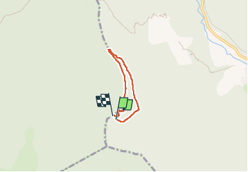
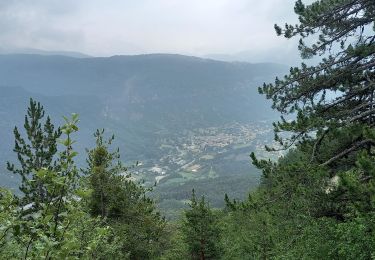
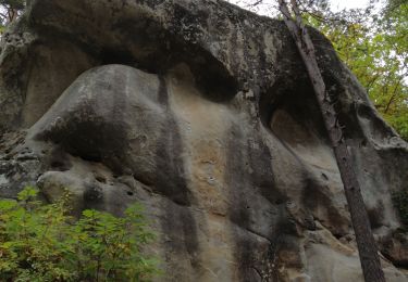
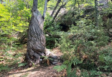
Ruta Senderismo de 3,9 km a descubrir en Provenza-Alpes-Costa Azul, Alpes de Alta Provenza, Annot. Esta ruta ha sido propuesta por Marchopier.
Descripción
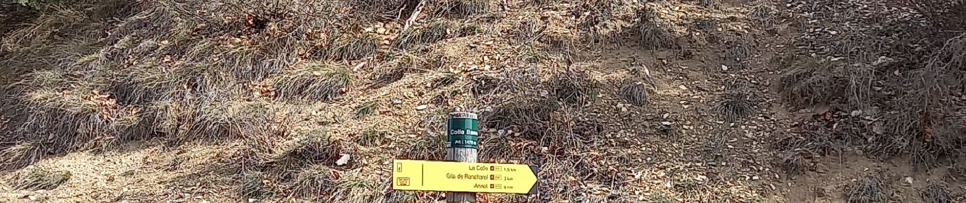
Départ du parking de Colle Basse en direction du Rent côté sud, montée vers le Table d'orientation par la crête du Roncheret puis descente au point de départ
Localización
País:
France
Región :
Provenza-Alpes-Costa Azul
Departamento/provincia :
Alpes de Alta Provenza
Municipio :
Annot
Localidad:
Unknown
Salida:(Dec)
Salida:(UTM)
309916 ; 4869956 (32T) N.
Comentarios
Excursiones cerca
![Excursión A pie Annot - Le Grès d'Annot - Photo](https://media.geolcdn.com/t/375/260/d494c9f4-04f5-4184-be97-f5fea23e1191.jpeg&format=jpg&maxdim=2)
![A pie A pie](https://static1.geolcdn.com/sitytour/trail-icons/100.png)
Le Grès d'Annot
A pie
Fácil
Annot,
Provenza-Alpes-Costa Azul,
Alpes de Alta Provenza,
France
![](/images/other/stat-length.png)
5,9 km | 10,9 km-effort
2h 28min
![](https://static1.geolcdn.com/siteimages/upload/files/16400158638029165_repeat_loop_refresh_sync_direction_icon.png)
Sí
![Excursión Senderismo Allons - 2024-11-29 Pic de Chamatte par Allons - Photo](https://media.geolcdn.com/t/375/260/97311ce2-81b2-4947-a084-db12309544ec.jpg&format=jpg&maxdim=2)
![Senderismo Senderismo](https://static1.geolcdn.com/sitytour/trail-icons/101.png)
2024-11-29 Pic de Chamatte par Allons
Senderismo
Muy difícil
Allons,
Provenza-Alpes-Costa Azul,
Alpes de Alta Provenza,
France
![](/images/other/stat-length.png)
15,6 km | 27 km-effort
6h 8min
![](https://static1.geolcdn.com/siteimages/upload/files/16400158638029165_repeat_loop_refresh_sync_direction_icon.png)
Sí
![Excursión Senderismo Annot - J4 Annot - Photo](https://media.geolcdn.com/t/375/260/be9d9d12-b8a6-45a8-bd70-6f8cacf32730.jpg&format=jpg&maxdim=2)
![Senderismo Senderismo](https://static1.geolcdn.com/sitytour/trail-icons/101.png)
J4 Annot
Senderismo
Medio
Annot,
Provenza-Alpes-Costa Azul,
Alpes de Alta Provenza,
France
![](/images/other/stat-length.png)
6,2 km | 11,3 km-effort
2h 34min
![](https://static1.geolcdn.com/siteimages/upload/files/16400158638029165_repeat_loop_refresh_sync_direction_icon.png)
Sí
![Senderismo Senderismo](https://static1.geolcdn.com/sitytour/trail-icons/101.png)
Les Grès d'Annot
Senderismo
Medio
Annot,
Provenza-Alpes-Costa Azul,
Alpes de Alta Provenza,
France
![](/images/other/stat-length.png)
5,8 km | 10,8 km-effort
2h 9min
![](https://static1.geolcdn.com/siteimages/upload/files/16400158638029165_repeat_loop_refresh_sync_direction_icon.png)
Sí
![Excursión Senderismo Annot - Rando gastro Roncharel - Photo](https://media.geolcdn.com/t/375/260/4e3f8487-9887-4ec3-94b2-d5bbd50aefe8.jpg&format=jpg&maxdim=2)
![Senderismo Senderismo](https://static1.geolcdn.com/sitytour/trail-icons/101.png)
Rando gastro Roncharel
Senderismo
Medio
Annot,
Provenza-Alpes-Costa Azul,
Alpes de Alta Provenza,
France
![](/images/other/stat-length.png)
5,8 km | 11,9 km-effort
2h 42min
![](https://static1.geolcdn.com/siteimages/upload/files/16400158638029165_repeat_loop_refresh_sync_direction_icon.png)
No
![Excursión Senderismo Annot - Les grès d'Annot - Photo](https://media.geolcdn.com/t/375/260/ext.jpg?maxdim=2&url=https%3A%2F%2Fstatic1.geolcdn.com%2Fsiteimages%2Fupload%2Ffiles%2F1553511878bg_sport_marche.png)
![Senderismo Senderismo](https://static1.geolcdn.com/sitytour/trail-icons/101.png)
Les grès d'Annot
Senderismo
Medio
(1)
Annot,
Provenza-Alpes-Costa Azul,
Alpes de Alta Provenza,
France
![](/images/other/stat-length.png)
11,5 km | 19,2 km-effort
6h 2min
![](https://static1.geolcdn.com/siteimages/upload/files/16400158638029165_repeat_loop_refresh_sync_direction_icon.png)
Sí
![Excursión Senderismo Braux - Rando Pieŕre qui tremble Chabrieres Peloussis Argenton - Photo](https://media.geolcdn.com/t/375/260/cfc0cc00-9a69-459b-9e00-f152d8d54736.jpg&format=jpg&maxdim=2)
![Senderismo Senderismo](https://static1.geolcdn.com/sitytour/trail-icons/101.png)
Rando Pieŕre qui tremble Chabrieres Peloussis Argenton
Senderismo
Medio
Braux,
Provenza-Alpes-Costa Azul,
Alpes de Alta Provenza,
France
![](/images/other/stat-length.png)
14 km | 22 km-effort
6h 27min
![](https://static1.geolcdn.com/siteimages/upload/files/16400158638029165_repeat_loop_refresh_sync_direction_icon.png)
Sí
![Excursión Senderismo Annot - Grès d'Annot Carte IGN 3541OT - Photo](https://media.geolcdn.com/t/375/260/9f9453a3-f8fb-41f4-87f9-67579e26dbf0.jpg&format=jpg&maxdim=2)
![Senderismo Senderismo](https://static1.geolcdn.com/sitytour/trail-icons/101.png)
Grès d'Annot Carte IGN 3541OT
Senderismo
Medio
Annot,
Provenza-Alpes-Costa Azul,
Alpes de Alta Provenza,
France
![](/images/other/stat-length.png)
11,3 km | 21 km-effort
7h 23min
![](https://static1.geolcdn.com/siteimages/upload/files/16400158638029165_repeat_loop_refresh_sync_direction_icon.png)
Sí
![Excursión Senderismo Annot - Les grès d'Annot-20-05-22 - Photo](https://media.geolcdn.com/t/375/260/3872c580-3dd5-4977-8057-6ad4a77228f8.jpg&format=jpg&maxdim=2)
![Senderismo Senderismo](https://static1.geolcdn.com/sitytour/trail-icons/101.png)
Les grès d'Annot-20-05-22
Senderismo
Medio
Annot,
Provenza-Alpes-Costa Azul,
Alpes de Alta Provenza,
France
![](/images/other/stat-length.png)
6,8 km | 12,4 km-effort
2h 20min
![](https://static1.geolcdn.com/siteimages/upload/files/16400158638029165_repeat_loop_refresh_sync_direction_icon.png)
No