![](/images/other/stat-length.png)
![Excursión Bici de montaña Sainte-Marie-sur-Ouche - Ste Marie st Jean de Boeuf Antheuil Retour Canal - Photo](https://media.geolcdn.com/t/1900/400/ext.pjpeg?maxdim=2&url=https%3A%2F%2Fstatic1.geolcdn.com%2Fsiteimages%2Fupload%2Ffiles%2F1524743154velo.jpg)
Ste Marie st Jean de Boeuf Antheuil Retour Canal
mricard
Usuario
![Longitud](/images/other/stat-length.png)
Longitud
40 km
![Altitud máxima](https://static1.geolcdn.com/siteimages/upload/files/1508320355ic_sort_altitude_max_24dp.png)
Altitud máxima
632 m
![Desnivel positivo](https://static1.geolcdn.com/siteimages/upload/files/1508320355ic_sort_den_pos_24dp.png)
Desnivel positivo
640 m
![Km-Effort](/images/other/stat-length.png)
Km-Effort
48 km
![Altitud mínima](https://static1.geolcdn.com/siteimages/upload/files/1508320355ic_sort_altitude_min_24dp.png)
Altitud mínima
282 m
![Desnivel negativo](https://static1.geolcdn.com/siteimages/upload/files/1508320355ic_sort_den_neg_24dp.png)
Desnivel negativo
640 m
![Boucle](https://static1.geolcdn.com/siteimages/upload/files/16400158638029165_repeat_loop_refresh_sync_direction_icon.png)
Boucle
Sí
Fecha de creación :
2023-03-16 13:56:45.919
Última modificación :
2023-03-16 13:59:25.941
![Bici de montaña](https://static1.geolcdn.com/sitytour/trail-icons/202.png)
3h55
Dificultad : Medio
![Escanee este código QR para abrir la excursión en la aplicación SityTrail](https://capi.geolives.com/qq0zvz2zws4bq2lad0pu/sitytour/trails/3586960/qr.png?size=200)
Aplicación GPS de excursión GRATIS
A propósito
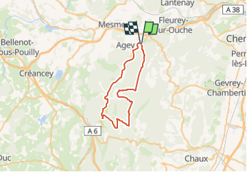
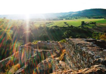
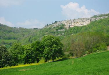
Ruta Bici de montaña de 40 km a descubrir en Borgoña-Franco Condado, Côte-d'Or, Sainte-Marie-sur-Ouche. Esta ruta ha sido propuesta por mricard.
Descripción
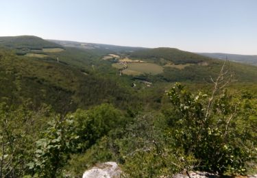
Une quarantaine de kilomètres en vélo. Chemins blancs en forêt avec quelques dénivelés, puis un retour tranquille par le chemin de halage.
Localización
País:
France
Región :
Borgoña-Franco Condado
Departamento/provincia :
Côte-d'Or
Municipio :
Sainte-Marie-sur-Ouche
Localidad:
Unknown
Salida:(Dec)
Salida:(UTM)
635732 ; 5238527 (31T) N.
Comentarios
Excursiones cerca
![Excursión Senderismo Sainte-Marie-sur-Ouche - Pont de Pany - Photo](https://media.geolcdn.com/t/375/260/880c73c5-f480-4d0e-b6d7-7819f4768403.jpg&format=jpg&maxdim=2)
![Senderismo Senderismo](https://static1.geolcdn.com/sitytour/trail-icons/101.png)
Pont de Pany
Senderismo
Fácil
(1)
Sainte-Marie-sur-Ouche,
Borgoña-Franco Condado,
Côte-d'Or,
France
![](/images/other/stat-length.png)
11,4 km | 16 km-effort
3h 19min
![](https://static1.geolcdn.com/siteimages/upload/files/16400158638029165_repeat_loop_refresh_sync_direction_icon.png)
Sí
![Excursión Senderismo Urcy - Les environs d'Urcy - Photo](https://media.geolcdn.com/t/375/260/ext.jpg?maxdim=2&url=https%3A%2F%2Fservices.sitytrail.com%2FGeolivesWS%2FDownloadMedia.ashx%3FTrailID%3D104689%26Media%3D8092_1.jpg)
![Senderismo Senderismo](https://static1.geolcdn.com/sitytour/trail-icons/101.png)
Les environs d'Urcy
Senderismo
Difícil
(2)
Urcy,
Borgoña-Franco Condado,
Côte-d'Or,
France
![](/images/other/stat-length.png)
18,9 km | 27 km-effort
6h 0min
![](https://static1.geolcdn.com/siteimages/upload/files/16400158638029165_repeat_loop_refresh_sync_direction_icon.png)
No
![Excursión Senderismo Barbirey-sur-Ouche - Le Tour de Barbiriacum - Barbirey sur Ouche - Photo](https://media.geolcdn.com/t/375/260/ext.jpg?maxdim=2&url=https%3A%2F%2Fservices.sitytrail.com%2FGeolivesWS%2FDownloadMedia.ashx%3FTrailID%3D104688%26Media%3D8091_1.jpg)
![Senderismo Senderismo](https://static1.geolcdn.com/sitytour/trail-icons/101.png)
Le Tour de Barbiriacum - Barbirey sur Ouche
Senderismo
Medio
(1)
Barbirey-sur-Ouche,
Borgoña-Franco Condado,
Côte-d'Or,
France
![](/images/other/stat-length.png)
10,5 km | 15,9 km-effort
2h 45min
![](https://static1.geolcdn.com/siteimages/upload/files/16400158638029165_repeat_loop_refresh_sync_direction_icon.png)
Sí
![Excursión Senderismo Sainte-Marie-sur-Ouche - Belvédères sur la vallée de l'Ouche - Pont de Pany - Photo](https://media.geolcdn.com/t/375/260/ext.jpg?maxdim=2&url=https%3A%2F%2Fservices.sitytrail.com%2FGeolivesWS%2FDownloadMedia.ashx%3FTrailID%3D104685%26Media%3D8088_1.jpg)
![Senderismo Senderismo](https://static1.geolcdn.com/sitytour/trail-icons/101.png)
Belvédères sur la vallée de l'Ouche - Pont de Pany
Senderismo
Difícil
(1)
Sainte-Marie-sur-Ouche,
Borgoña-Franco Condado,
Côte-d'Or,
France
![](/images/other/stat-length.png)
20 km | 28 km-effort
6h 0min
![](https://static1.geolcdn.com/siteimages/upload/files/16400158638029165_repeat_loop_refresh_sync_direction_icon.png)
Sí
![Excursión Senderismo Mâlain - Mâlain - Charmoy - Baulme le Roche - Photo](https://media.geolcdn.com/t/375/260/ext.jpg?maxdim=2&url=https%3A%2F%2Fservices.sitytrail.com%2FGeolivesWS%2FDownloadMedia.ashx%3FTrailID%3D104684%26Media%3D8087_1.jpg)
![Senderismo Senderismo](https://static1.geolcdn.com/sitytour/trail-icons/101.png)
Mâlain - Charmoy - Baulme le Roche
Senderismo
Medio
(3)
Mâlain,
Borgoña-Franco Condado,
Côte-d'Or,
France
![](/images/other/stat-length.png)
15,3 km | 21 km-effort
3h 30min
![](https://static1.geolcdn.com/siteimages/upload/files/16400158638029165_repeat_loop_refresh_sync_direction_icon.png)
Sí
![Excursión Senderismo Fleurey-sur-Ouche - Le Marathon de Fleurey sur Ouche - Photo](https://media.geolcdn.com/t/375/260/ext.jpg?maxdim=2&url=https%3A%2F%2Fservices.sitytrail.com%2FGeolivesWS%2FDownloadMedia.ashx%3FTrailID%3D104675%26Media%3D8078_1.jpg)
![Senderismo Senderismo](https://static1.geolcdn.com/sitytour/trail-icons/101.png)
Le Marathon de Fleurey sur Ouche
Senderismo
Muy difícil
(1)
Fleurey-sur-Ouche,
Borgoña-Franco Condado,
Côte-d'Or,
France
![](/images/other/stat-length.png)
40 km | 54 km-effort
10h 0min
![](https://static1.geolcdn.com/siteimages/upload/files/16400158638029165_repeat_loop_refresh_sync_direction_icon.png)
Sí
![Excursión Bici eléctrica Sainte-Marie-sur-Ouche - Canal de Bourgogne_Etape 6 - Photo](https://media.geolcdn.com/t/375/260/ext.jpg?maxdim=2&url=https%3A%2F%2Fstatic1.geolcdn.com%2Fsiteimages%2Fupload%2Ffiles%2F1524743154velo.jpg)
![Bici eléctrica Bici eléctrica](https://static1.geolcdn.com/sitytour/trail-icons/205.png)
Canal de Bourgogne_Etape 6
Bici eléctrica
Muy fácil
(1)
Sainte-Marie-sur-Ouche,
Borgoña-Franco Condado,
Côte-d'Or,
France
![](/images/other/stat-length.png)
22 km | 23 km-effort
Desconocido
![](https://static1.geolcdn.com/siteimages/upload/files/16400158638029165_repeat_loop_refresh_sync_direction_icon.png)
No
![Excursión A pie Mâlain - Sentier du Mâlain - Photo](https://media.geolcdn.com/t/375/260/ac839600-ec98-4d3e-b54d-0b1e7cde5571.jpeg&format=jpg&maxdim=2)
![A pie A pie](https://static1.geolcdn.com/sitytour/trail-icons/100.png)
Sentier du Mâlain
A pie
Fácil
Mâlain,
Borgoña-Franco Condado,
Côte-d'Or,
France
![](/images/other/stat-length.png)
6,6 km | 10,5 km-effort
2h 22min
![](https://static1.geolcdn.com/siteimages/upload/files/16400158638029165_repeat_loop_refresh_sync_direction_icon.png)
Sí
![Excursión A pie Fleurey-sur-Ouche - Sentier des Roches d'Orgères - Photo](https://media.geolcdn.com/t/375/260/22d3f48c-a3a5-4f31-ac6b-414d68092044.jpeg&format=jpg&maxdim=2)
![A pie A pie](https://static1.geolcdn.com/sitytour/trail-icons/100.png)
Sentier des Roches d'Orgères
A pie
Fácil
Fleurey-sur-Ouche,
Borgoña-Franco Condado,
Côte-d'Or,
France
![](/images/other/stat-length.png)
4,2 km | 4,8 km-effort
1h 4min
![](https://static1.geolcdn.com/siteimages/upload/files/16400158638029165_repeat_loop_refresh_sync_direction_icon.png)
Sí