![](/images/other/stat-length.png)
![Excursión Senderismo Estoublon - Gorges de Trevans par Valbonnette - Photo](https://media.geolcdn.com/t/1900/400/10517f6a-6ec3-4f7b-85a2-34d58762c642.jpg&format=pjpeg&maxdim=2)
Gorges de Trevans par Valbonnette
Marchopier
Usuario
![Longitud](/images/other/stat-length.png)
![Altitud máxima](https://static1.geolcdn.com/siteimages/upload/files/1508320355ic_sort_altitude_max_24dp.png)
![Desnivel positivo](https://static1.geolcdn.com/siteimages/upload/files/1508320355ic_sort_den_pos_24dp.png)
![Km-Effort](/images/other/stat-length.png)
![Altitud mínima](https://static1.geolcdn.com/siteimages/upload/files/1508320355ic_sort_altitude_min_24dp.png)
![Desnivel negativo](https://static1.geolcdn.com/siteimages/upload/files/1508320355ic_sort_den_neg_24dp.png)
![Boucle](https://static1.geolcdn.com/siteimages/upload/files/16400158638029165_repeat_loop_refresh_sync_direction_icon.png)
![Senderismo](https://static1.geolcdn.com/sitytour/trail-icons/101.png)
5h08
Dificultad : Fácil
![Escanee este código QR para abrir la excursión en la aplicación SityTrail](https://capi.geolives.com/qq0zvz2zws4bq2lad0pu/sitytour/trails/3579175/qr.png?size=200)
Aplicación GPS de excursión GRATIS
A propósito
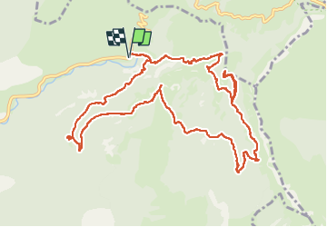
Ruta Senderismo de 13,9 km a descubrir en Provenza-Alpes-Costa Azul, Alpes de Alta Provenza, Estoublon. Esta ruta ha sido propuesta por Marchopier.
Descripción
Départ du parking du hameau de Trévans.
Après le pont sur l'Estoublaïsse, direction à droite sur le sentier montant vers les ruines du château de Trévans, le gîte et son bassin
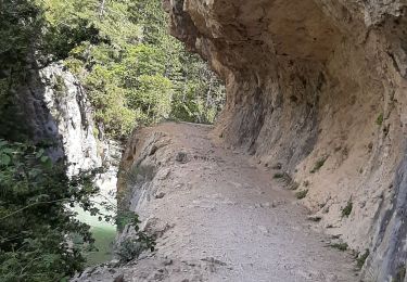
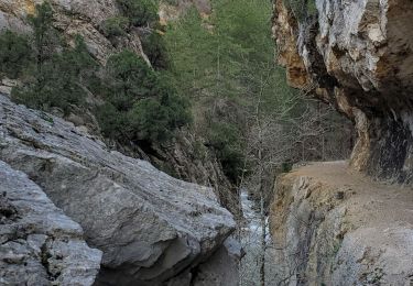
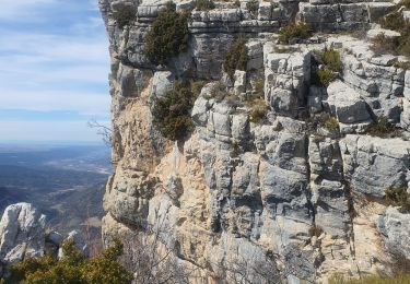
Retour sur la piste en direction du sentier du belvédère ,où des passages aériens sont équipés de main courante.
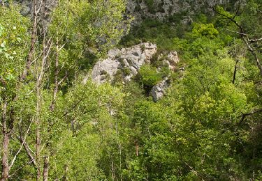
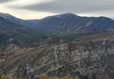
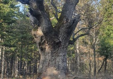
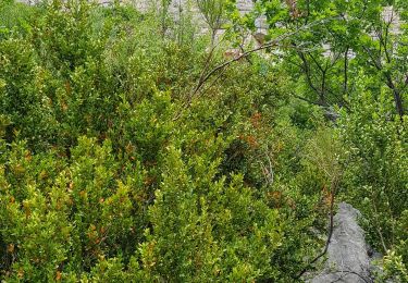
Après le point de vue du Belvédère sur la campagne provençale environnante et les cimes lointaines ennneigées , le sentier traverse la forêt ,atteint le hameau en ruines de Valbonnette, franchit le ravin de Mayaiche , et sur des passerelles celui du Clovion avant de remonter vers la Chapelle de Saint-André-du Désert
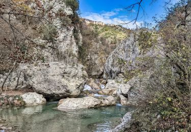
Le tracé redescend par le même sentier , puis bifurque à droite pour rejoindre le carrefour des gorges où l'Estoublaïsses rejoint le Clovion.
Encore des passages escarpés au-dessus du torrent ,avant de retrouver le point de départ
Localización
Comentarios
Excursiones cerca
![Excursión Senderismo Estoublon - Gorges de Trévans - Estoublon - Photo](https://media.geolcdn.com/t/375/260/ext.jpg?maxdim=2&url=https%3A%2F%2Fservices.sitytrail.com%2FGeolivesWS%2FDownloadMedia.ashx%3FTrailID%3D106721%26Media%3D11374_5.jpg)
![Senderismo Senderismo](https://static1.geolcdn.com/sitytour/trail-icons/101.png)
Senderismo
![](/images/other/stat-length.png)
![](https://static1.geolcdn.com/siteimages/upload/files/16400158638029165_repeat_loop_refresh_sync_direction_icon.png)
![Excursión Senderismo Estoublon - TREVANS, Chateau de Trevans, les Beluguettes. Cotes Chaudes , Belvédère des Gorges , Turquet ,o quet - Photo](https://media.geolcdn.com/t/375/260/488d605b-c812-4edd-a2c1-2f4802305dc3.jpg&format=jpg&maxdim=2)
![Senderismo Senderismo](https://static1.geolcdn.com/sitytour/trail-icons/101.png)
Senderismo
![](/images/other/stat-length.png)
![](https://static1.geolcdn.com/siteimages/upload/files/16400158638029165_repeat_loop_refresh_sync_direction_icon.png)
![Excursión Senderismo Beynes - Montagne de Beynes 11kms 720m - Photo](https://media.geolcdn.com/t/375/260/0924528c-4d8c-48ab-ad20-f85077c2766f.jpg&format=jpg&maxdim=2)
![Senderismo Senderismo](https://static1.geolcdn.com/sitytour/trail-icons/101.png)
Senderismo
![](/images/other/stat-length.png)
![](https://static1.geolcdn.com/siteimages/upload/files/16400158638029165_repeat_loop_refresh_sync_direction_icon.png)
![Excursión Senderismo Estoublon - estoublon sentier des oliviers gorges trevans 21k 950m - Photo](https://media.geolcdn.com/t/375/260/97fef695-e744-4be1-a5ca-e4eaf9bd8881.jpg&format=jpg&maxdim=2)
![Senderismo Senderismo](https://static1.geolcdn.com/sitytour/trail-icons/101.png)
Senderismo
![](/images/other/stat-length.png)
![](https://static1.geolcdn.com/siteimages/upload/files/16400158638029165_repeat_loop_refresh_sync_direction_icon.png)
![Excursión Senderismo Estoublon - Trevans les gorges - Photo](https://media.geolcdn.com/t/375/260/2cbe37e7-5ddf-4213-89bc-0a9ca520d8c1.jpg&format=jpg&maxdim=2)
![Senderismo Senderismo](https://static1.geolcdn.com/sitytour/trail-icons/101.png)
Senderismo
![](/images/other/stat-length.png)
![](https://static1.geolcdn.com/siteimages/upload/files/16400158638029165_repeat_loop_refresh_sync_direction_icon.png)
![Excursión Senderismo Beynes - 2023-03-17 Montagne de Beyne - Photo](https://media.geolcdn.com/t/375/260/a2f9f9ce-2317-441f-8351-fbd6bbd22b1f.jpg&format=jpg&maxdim=2)
![Senderismo Senderismo](https://static1.geolcdn.com/sitytour/trail-icons/101.png)
Senderismo
![](/images/other/stat-length.png)
![](https://static1.geolcdn.com/siteimages/upload/files/16400158638029165_repeat_loop_refresh_sync_direction_icon.png)
![Excursión Senderismo Estoublon - 2023-02-21 Gorges de Trévans - Passerelle de la Délasse - Photo](https://media.geolcdn.com/t/375/260/0eeaaad3-f154-4199-b0d4-f7114f5176f6.jpg&format=jpg&maxdim=2)
![Senderismo Senderismo](https://static1.geolcdn.com/sitytour/trail-icons/101.png)
Senderismo
![](/images/other/stat-length.png)
![](https://static1.geolcdn.com/siteimages/upload/files/16400158638029165_repeat_loop_refresh_sync_direction_icon.png)
![Excursión Senderismo Beynes - 04 La montagne de Beynes (Variante 05/2022) - Photo](https://media.geolcdn.com/t/375/260/00ffcda8-2af0-4879-a93e-d3abe306c026.jpg&format=jpg&maxdim=2)
![Senderismo Senderismo](https://static1.geolcdn.com/sitytour/trail-icons/101.png)
Senderismo
![](/images/other/stat-length.png)
![](https://static1.geolcdn.com/siteimages/upload/files/16400158638029165_repeat_loop_refresh_sync_direction_icon.png)
![Excursión Senderismo Estoublon - gorges de trevans sentier de valbonette - Photo](https://media.geolcdn.com/t/375/260/e95b5ac0-ca3e-4559-bbd5-f5d21be426a1.jpg&format=jpg&maxdim=2)
![Senderismo Senderismo](https://static1.geolcdn.com/sitytour/trail-icons/101.png)
Senderismo
![](/images/other/stat-length.png)
![](https://static1.geolcdn.com/siteimages/upload/files/16400158638029165_repeat_loop_refresh_sync_direction_icon.png)