![](/images/other/stat-length.png)
![Excursión Senderismo Lieja - Wikiloc - Lande de Streupas - Photo](https://media.geolcdn.com/t/1900/400/4977bcf8-745e-451c-8616-ca5519ba3a04.jpg&format=pjpeg&maxdim=2)
Wikiloc - Lande de Streupas
beautrix
Usuario
![Longitud](/images/other/stat-length.png)
Longitud
10,2 km
![Altitud máxima](https://static1.geolcdn.com/siteimages/upload/files/1508320355ic_sort_altitude_max_24dp.png)
Altitud máxima
192 m
![Desnivel positivo](https://static1.geolcdn.com/siteimages/upload/files/1508320355ic_sort_den_pos_24dp.png)
Desnivel positivo
204 m
![Km-Effort](/images/other/stat-length.png)
Km-Effort
13 km
![Altitud mínima](https://static1.geolcdn.com/siteimages/upload/files/1508320355ic_sort_altitude_min_24dp.png)
Altitud mínima
43 m
![Desnivel negativo](https://static1.geolcdn.com/siteimages/upload/files/1508320355ic_sort_den_neg_24dp.png)
Desnivel negativo
213 m
![Boucle](https://static1.geolcdn.com/siteimages/upload/files/16400158638029165_repeat_loop_refresh_sync_direction_icon.png)
Boucle
Sí
Fecha de creación :
2023-03-01 17:15:39.05
Última modificación :
2023-03-04 13:53:04.356
![Senderismo](https://static1.geolcdn.com/sitytour/trail-icons/101.png)
2h56
Dificultad : Difícil
![Escanee este código QR para abrir la excursión en la aplicación SityTrail](https://capi.geolives.com/qq0zvz2zws4bq2lad0pu/sitytour/trails/3569831/qr.png?size=200)
Aplicación GPS de excursión GRATIS
A propósito
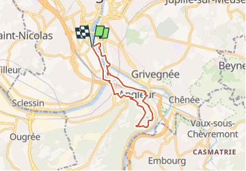
Ruta Senderismo de 10,2 km a descubrir en Valonia, Lieja, Lieja. Esta ruta ha sido propuesta por beautrix.
Descripción
Une balade pour découvrir les quais de Meuse, le canal de l'Ourthe et la lande de Streupas, un coin boisé sur les hauts de Liège et d'Angleur où la nature sauvage côtoie la ville.
Localización
País:
Belgium
Región :
Valonia
Departamento/provincia :
Lieja
Municipio :
Lieja
Localidad:
Unknown
Salida:(Dec)
Salida:(UTM)
681998 ; 5611580 (31U) N.
Comentarios
Excursiones cerca
![Excursión Senderismo Chaudfontaine - RB-Lg-21_Chaudfontaine_via-racc-1-et-2 - Photo](https://media.geolcdn.com/t/375/260/ext.jpg?maxdim=2&url=https%3A%2F%2Fservices.sitytrail.com%2FGeolivesWS%2FDownloadMedia.ashx%3FTrailID%3D400756%26Media%3Db4e5d748-2e9a-46aa-887f-e41bafbe80d7.jpg)
![Senderismo Senderismo](https://static1.geolcdn.com/sitytour/trail-icons/101.png)
RB-Lg-21_Chaudfontaine_via-racc-1-et-2
Senderismo
Difícil
(9)
Chaudfontaine,
Valonia,
Lieja,
Belgium
![](/images/other/stat-length.png)
11,6 km | 16,5 km-effort
3h 45min
![](https://static1.geolcdn.com/siteimages/upload/files/16400158638029165_repeat_loop_refresh_sync_direction_icon.png)
Sí
![Excursión Senderismo Chaudfontaine - RB-Lg-21_Chaudfontaine - Photo](https://media.geolcdn.com/t/375/260/ext.jpg?maxdim=2&url=https%3A%2F%2Fservices.sitytrail.com%2FGeolivesWS%2FDownloadMedia.ashx%3FTrailID%3D400753%26Media%3D0173f844-fd8a-4443-984d-43fa65695365.jpg)
![Senderismo Senderismo](https://static1.geolcdn.com/sitytour/trail-icons/101.png)
RB-Lg-21_Chaudfontaine
Senderismo
(14)
Chaudfontaine,
Valonia,
Lieja,
Belgium
![](/images/other/stat-length.png)
18 km | 26 km-effort
5h 56min
![](https://static1.geolcdn.com/siteimages/upload/files/16400158638029165_repeat_loop_refresh_sync_direction_icon.png)
Sí
![Excursión Senderismo Lieja - Nuit du scoutisme - Liège - Photo](https://media.geolcdn.com/t/375/260/9ee5fcc5-2ed6-4f9c-9105-1fa3b4422f73.jpg&format=jpg&maxdim=2)
![Senderismo Senderismo](https://static1.geolcdn.com/sitytour/trail-icons/101.png)
Nuit du scoutisme - Liège
Senderismo
Fácil
(12)
Lieja,
Valonia,
Lieja,
Belgium
![](/images/other/stat-length.png)
4,2 km | 6 km-effort
1h 19min
![](https://static1.geolcdn.com/siteimages/upload/files/16400158638029165_repeat_loop_refresh_sync_direction_icon.png)
Sí
![Excursión Senderismo Lieja - coteaux de la citadelle liège - Photo](https://media.geolcdn.com/t/375/260/ext.jpg?maxdim=2&url=https%3A%2F%2Fservices.sitytrail.com%2FGeolivesWS%2FDownloadMedia.ashx%3FTrailID%3D114030%26Media%3D89e4d7f6-fadf-43e4-96ab-3cccd7baadb9.jpg)
![Senderismo Senderismo](https://static1.geolcdn.com/sitytour/trail-icons/101.png)
coteaux de la citadelle liège
Senderismo
Medio
(6)
Lieja,
Valonia,
Lieja,
Belgium
![](/images/other/stat-length.png)
14,3 km | 19,8 km-effort
7h 4min
![](https://static1.geolcdn.com/siteimages/upload/files/16400158638029165_repeat_loop_refresh_sync_direction_icon.png)
Sí
![Excursión Senderismo Lieja - GG-Lg-10_Angleur - Nessonvaux - Photo](https://media.geolcdn.com/t/375/260/04d5e1fb-7fbe-4c80-8636-73a8d0ed7b0e.jpg&format=jpg&maxdim=2)
![Senderismo Senderismo](https://static1.geolcdn.com/sitytour/trail-icons/101.png)
GG-Lg-10_Angleur - Nessonvaux
Senderismo
Muy difícil
(2)
Lieja,
Valonia,
Lieja,
Belgium
![](/images/other/stat-length.png)
22 km | 32 km-effort
6h 27min
![](https://static1.geolcdn.com/siteimages/upload/files/16400158638029165_repeat_loop_refresh_sync_direction_icon.png)
No
![Excursión Senderismo Chaudfontaine - RB-Lg-21_Chaudfontaine_via-racc-1 - Photo](https://media.geolcdn.com/t/375/260/ext.jpg?maxdim=2&url=https%3A%2F%2Fservices.sitytrail.com%2FGeolivesWS%2FDownloadMedia.ashx%3FTrailID%3D400755%26Media%3Db4e5d748-2e9a-46aa-887f-e41bafbe80d7.jpg)
![Senderismo Senderismo](https://static1.geolcdn.com/sitytour/trail-icons/101.png)
RB-Lg-21_Chaudfontaine_via-racc-1
Senderismo
Muy difícil
(3)
Chaudfontaine,
Valonia,
Lieja,
Belgium
![](/images/other/stat-length.png)
14,9 km | 22 km-effort
5h 1min
![](https://static1.geolcdn.com/siteimages/upload/files/16400158638029165_repeat_loop_refresh_sync_direction_icon.png)
Sí
![Excursión Senderismo Lieja - liege st lambert versant gauche entre ville et nature - Photo](https://media.geolcdn.com/t/375/260/88c52680-ebe2-4244-8d59-4bcee560958c.jpg&format=jpg&maxdim=2)
![Senderismo Senderismo](https://static1.geolcdn.com/sitytour/trail-icons/101.png)
liege st lambert versant gauche entre ville et nature
Senderismo
Medio
(1)
Lieja,
Valonia,
Lieja,
Belgium
![](/images/other/stat-length.png)
10,5 km | 14 km-effort
2h 31min
![](https://static1.geolcdn.com/siteimages/upload/files/16400158638029165_repeat_loop_refresh_sync_direction_icon.png)
Sí
![Excursión Senderismo Chaudfontaine - La découverte de Sauheid et rocher du bout du monde - Photo](https://media.geolcdn.com/t/375/260/13dd1432-7408-4af2-9183-0d845172c158.jpg&format=jpg&maxdim=2)
![Senderismo Senderismo](https://static1.geolcdn.com/sitytour/trail-icons/101.png)
La découverte de Sauheid et rocher du bout du monde
Senderismo
Medio
(1)
Chaudfontaine,
Valonia,
Lieja,
Belgium
![](/images/other/stat-length.png)
7,8 km | 10,2 km-effort
2h 18min
![](https://static1.geolcdn.com/siteimages/upload/files/16400158638029165_repeat_loop_refresh_sync_direction_icon.png)
Sí
![Excursión Senderismo Lieja - 2021-03-07_15h45m11_1615128300605_UnnMrtGYyrs - Photo](https://media.geolcdn.com/t/375/260/1db82134-c6f1-4cf9-9ec5-4781d8a78844.jpg&format=jpg&maxdim=2)
![Senderismo Senderismo](https://static1.geolcdn.com/sitytour/trail-icons/101.png)
2021-03-07_15h45m11_1615128300605_UnnMrtGYyrs
Senderismo
Fácil
(1)
Lieja,
Valonia,
Lieja,
Belgium
![](/images/other/stat-length.png)
3 km | 3,9 km-effort
53min
![](https://static1.geolcdn.com/siteimages/upload/files/16400158638029165_repeat_loop_refresh_sync_direction_icon.png)
Sí