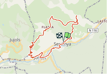
![](/images/other/stat-length.png)
![Excursión Senderismo Serdinya - Serdinya, découverte de la Segonie. - Photo](https://media.geolcdn.com/t/1900/400/ext.pjpeg?maxdim=2&url=https%3A%2F%2Fstatic1.geolcdn.com%2Fsiteimages%2Fupload%2Ffiles%2F1553511878bg_sport_marche.png)
Serdinya, découverte de la Segonie.
Santblasi
Usuario
![Longitud](/images/other/stat-length.png)
![Altitud máxima](https://static1.geolcdn.com/siteimages/upload/files/1508320355ic_sort_altitude_max_24dp.png)
![Desnivel positivo](https://static1.geolcdn.com/siteimages/upload/files/1508320355ic_sort_den_pos_24dp.png)
![Km-Effort](/images/other/stat-length.png)
![Altitud mínima](https://static1.geolcdn.com/siteimages/upload/files/1508320355ic_sort_altitude_min_24dp.png)
![Desnivel negativo](https://static1.geolcdn.com/siteimages/upload/files/1508320355ic_sort_den_neg_24dp.png)
![Boucle](https://static1.geolcdn.com/siteimages/upload/files/16400158638029165_repeat_loop_refresh_sync_direction_icon.png)
![Senderismo](https://static1.geolcdn.com/sitytour/trail-icons/101.png)
4h45
Dificultad : Medio
![Escanee este código QR para abrir la excursión en la aplicación SityTrail](https://capi.geolives.com/qq0zvz2zws4bq2lad0pu/sitytour/trails/3560710/qr.png?size=200)
Aplicación GPS de excursión GRATIS
A propósito
Ruta Senderismo de 11 km a descubrir en Occitania, Pirineos Orientales, Serdinya. Esta ruta ha sido propuesta por Santblasi.
Descripción
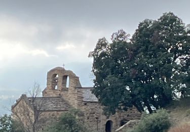
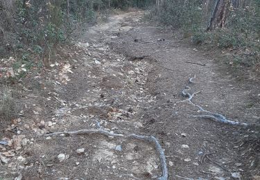
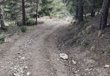
parking entrée de Serdinya. Prendre le sentier muletier dans le virage. Grimper jusqu'à l'ancienne tour de La Guardia. Continuer en face au cairn, suivre la trace jusqu'à Marinyans. Restes d'une chapelle.
grimper vers les Horts, hameau en ruine, maison de berger.
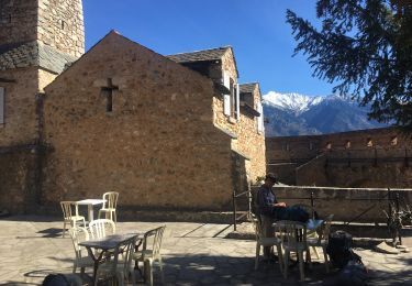
Retour et continuer jusqu'à Flassa, église.
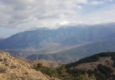
Nombreuses belles vues.
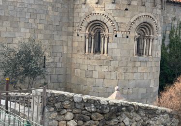
Descente sur la piste DFCI, continuer dans Joncet (lavoir, église, pont, ex moulin ). Serdinya église.
Localización
Comentarios
Excursiones cerca
![Excursión Senderismo Jujols - Jujols 1 - Photo](https://media.geolcdn.com/t/375/260/ext.jpg?maxdim=2&url=https%3A%2F%2Fstatic1.geolcdn.com%2Fsiteimages%2Fupload%2Ffiles%2F1553511878bg_sport_marche.png)
![Senderismo Senderismo](https://static1.geolcdn.com/sitytour/trail-icons/101.png)
Senderismo
![](/images/other/stat-length.png)
![](https://static1.geolcdn.com/siteimages/upload/files/16400158638029165_repeat_loop_refresh_sync_direction_icon.png)
![Excursión sport Corneilla-de-Conflent - 20241219 Boucle depuis Villefranche-de-Conflent - Photo](https://media.geolcdn.com/t/375/260/181e15a5-6185-4f02-acf7-8c66afb44142.jpg&format=jpg&maxdim=2)
sport
![](/images/other/stat-length.png)
![](https://static1.geolcdn.com/siteimages/upload/files/16400158638029165_repeat_loop_refresh_sync_direction_icon.png)
![Excursión sport Serdinya - 20241101 Flassa - Photo](https://media.geolcdn.com/t/375/260/f07b9580-16b6-4e63-93d6-f8d7129b2a58.jpg&format=jpg&maxdim=2)
sport
![](/images/other/stat-length.png)
![](https://static1.geolcdn.com/siteimages/upload/files/16400158638029165_repeat_loop_refresh_sync_direction_icon.png)
![Excursión Senderismo Fuilla - fuilla (66) - Photo](https://media.geolcdn.com/t/375/260/52a4cc98-58c8-4d12-9f81-88a2231fa3d3.jpg&format=jpg&maxdim=2)
![Senderismo Senderismo](https://static1.geolcdn.com/sitytour/trail-icons/101.png)
Senderismo
![](/images/other/stat-length.png)
![](https://static1.geolcdn.com/siteimages/upload/files/16400158638029165_repeat_loop_refresh_sync_direction_icon.png)
![Excursión Senderismo Corneilla-de-Conflent - Corneilla de Conflent - Photo](https://media.geolcdn.com/t/375/260/87184567-2ca4-4199-b850-a35026a3725a.jpg&format=jpg&maxdim=2)
![Senderismo Senderismo](https://static1.geolcdn.com/sitytour/trail-icons/101.png)
Senderismo
![](/images/other/stat-length.png)
![](https://static1.geolcdn.com/siteimages/upload/files/16400158638029165_repeat_loop_refresh_sync_direction_icon.png)
![Excursión Senderismo Jujols - jujols marbre rouge - Photo](https://media.geolcdn.com/t/375/260/d6c9b4b1-cdb0-48e3-bb77-be480f69b8dc.jpg&format=jpg&maxdim=2)
![Senderismo Senderismo](https://static1.geolcdn.com/sitytour/trail-icons/101.png)
Senderismo
![](/images/other/stat-length.png)
![](https://static1.geolcdn.com/siteimages/upload/files/16400158638029165_repeat_loop_refresh_sync_direction_icon.png)
![Excursión Senderismo Sahorre - Thorrent - Py et le Rec de Thorrent - Photo](https://media.geolcdn.com/t/375/260/8b3a94e2-bb52-4892-8615-4460d996cc11.jpg&format=jpg&maxdim=2)
![Senderismo Senderismo](https://static1.geolcdn.com/sitytour/trail-icons/101.png)
Senderismo
![](/images/other/stat-length.png)
![](https://static1.geolcdn.com/siteimages/upload/files/16400158638029165_repeat_loop_refresh_sync_direction_icon.png)
![Excursión Senderismo Fuilla - Ville franche / fort Liberia /Chapelle St André de Bell lloc / St esteve de calmeilles - Photo](https://media.geolcdn.com/t/375/260/470eeb99-3cac-42f3-a8ba-bdbabe475ec4.jpg&format=jpg&maxdim=2)
![Senderismo Senderismo](https://static1.geolcdn.com/sitytour/trail-icons/101.png)
Senderismo
![](/images/other/stat-length.png)
![](https://static1.geolcdn.com/siteimages/upload/files/16400158638029165_repeat_loop_refresh_sync_direction_icon.png)
![Excursión Senderismo Serdinya - flassa. taratera 850 positif 13km 4h30 - Photo](https://media.geolcdn.com/t/375/260/b3222516-f8b3-464a-ab73-685b2064e32d.jpg&format=jpg&maxdim=2)
![Senderismo Senderismo](https://static1.geolcdn.com/sitytour/trail-icons/101.png)
Senderismo
![](/images/other/stat-length.png)
![](https://static1.geolcdn.com/siteimages/upload/files/16400158638029165_repeat_loop_refresh_sync_direction_icon.png)