![](/images/other/stat-length.png)
![Excursión Senderismo Cormoranche-sur-Saône - Cormoranche /Saône: voie bleue et village - Photo](https://media.geolcdn.com/t/1900/400/ext.pjpeg?maxdim=2&url=https%3A%2F%2Fstatic1.geolcdn.com%2Fsiteimages%2Fupload%2Ffiles%2F1553511878bg_sport_marche.png)
Cormoranche /Saône: voie bleue et village
robertdurand
Usuario
![Longitud](/images/other/stat-length.png)
Longitud
7,6 km
![Altitud máxima](https://static1.geolcdn.com/siteimages/upload/files/1508320355ic_sort_altitude_max_24dp.png)
Altitud máxima
179 m
![Desnivel positivo](https://static1.geolcdn.com/siteimages/upload/files/1508320355ic_sort_den_pos_24dp.png)
Desnivel positivo
42 m
![Km-Effort](/images/other/stat-length.png)
Km-Effort
8,2 km
![Altitud mínima](https://static1.geolcdn.com/siteimages/upload/files/1508320355ic_sort_altitude_min_24dp.png)
Altitud mínima
166 m
![Desnivel negativo](https://static1.geolcdn.com/siteimages/upload/files/1508320355ic_sort_den_neg_24dp.png)
Desnivel negativo
41 m
![Boucle](https://static1.geolcdn.com/siteimages/upload/files/16400158638029165_repeat_loop_refresh_sync_direction_icon.png)
Boucle
Sí
Fecha de creación :
2023-02-11 13:19:48.0
Última modificación :
2023-02-11 16:44:38.09
![Senderismo](https://static1.geolcdn.com/sitytour/trail-icons/101.png)
1h57
Dificultad : Muy fácil
![Escanee este código QR para abrir la excursión en la aplicación SityTrail](https://capi.geolives.com/qq0zvz2zws4bq2lad0pu/sitytour/trails/3548094/qr.png?size=200)
Aplicación GPS de excursión GRATIS
A propósito
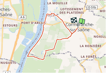
Ruta Senderismo de 7,6 km a descubrir en Auvergne-Rhône-Alpes, Ain, Cormoranche-sur-Saône. Esta ruta ha sido propuesta por robertdurand.
Descripción
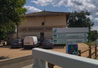
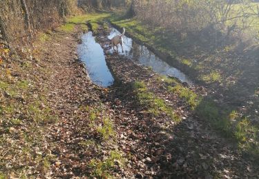
Du centre du village, nous allons en direction de la Saône où des travaux sur la rive crée une véloroute appelée voie bleue
Localización
País:
France
Región :
Auvergne-Rhône-Alpes
Departamento/provincia :
Ain
Municipio :
Cormoranche-sur-Saône
Localidad:
Unknown
Salida:(Dec)
Salida:(UTM)
641156 ; 5122319 (31T) N.
Comentarios
Excursiones cerca
![Excursión Paseo ecuestre Laiz - Bords de Saône. Version inondée - Photo](https://media.geolcdn.com/t/375/260/ext.jpg?maxdim=2&url=https%3A%2F%2Fstatic1.geolcdn.com%2Fsiteimages%2Fupload%2Ffiles%2F1524743154cheval.jpg)
![Paseo ecuestre Paseo ecuestre](https://static1.geolcdn.com/sitytour/trail-icons/301.png)
Bords de Saône. Version inondée
Paseo ecuestre
Difícil
(1)
Laiz,
Auvergne-Rhône-Alpes,
Ain,
France
![](/images/other/stat-length.png)
31 km | 35 km-effort
4h 33min
![](https://static1.geolcdn.com/siteimages/upload/files/16400158638029165_repeat_loop_refresh_sync_direction_icon.png)
Sí
![Excursión Bici de carretera Cormoranche-sur-Saône - 01 voie verte et bleue macon - Photo](https://media.geolcdn.com/t/375/260/db10580d-accf-4352-a58c-c49df6817574.jpg&format=jpg&maxdim=2)
![Bici de carretera Bici de carretera](https://static1.geolcdn.com/sitytour/trail-icons/201.png)
01 voie verte et bleue macon
Bici de carretera
Medio
Cormoranche-sur-Saône,
Auvergne-Rhône-Alpes,
Ain,
France
![](/images/other/stat-length.png)
74 km | 84 km-effort
4h 45min
![](https://static1.geolcdn.com/siteimages/upload/files/16400158638029165_repeat_loop_refresh_sync_direction_icon.png)
Sí
![Excursión Senderismo Vinzelles - Vinzelles - Photo](https://media.geolcdn.com/t/375/260/7181b66c-80aa-4352-9c5c-e9c9e7accae6.jpg&format=jpg&maxdim=2)
![Senderismo Senderismo](https://static1.geolcdn.com/sitytour/trail-icons/101.png)
Vinzelles
Senderismo
Fácil
(1)
Vinzelles,
Borgoña-Franco Condado,
Saona y Loira,
France
![](/images/other/stat-length.png)
7,8 km | 10,1 km-effort
2h 6min
![](https://static1.geolcdn.com/siteimages/upload/files/16400158638029165_repeat_loop_refresh_sync_direction_icon.png)
Sí
![Excursión A pie Mâcon - sejour-rcy-les-cretes-du-haut-beaujolais-journee-1-nhUCI6cmgv - Photo](https://media.geolcdn.com/t/375/260/ext.jpg?maxdim=2&url=https%3A%2F%2Fstatic1.geolcdn.com%2Fsiteimages%2Fupload%2Ffiles%2F1545311037marcheuse_200dpi.jpg)
![A pie A pie](https://static1.geolcdn.com/sitytour/trail-icons/100.png)
sejour-rcy-les-cretes-du-haut-beaujolais-journee-1-nhUCI6cmgv
A pie
Difícil
Mâcon,
Borgoña-Franco Condado,
Saona y Loira,
France
![](/images/other/stat-length.png)
23 km | 35 km-effort
8h 2min
![](https://static1.geolcdn.com/siteimages/upload/files/16400158638029165_repeat_loop_refresh_sync_direction_icon.png)
No
![Excursión Senderismo La Chapelle-de-Guinchay - 10 - Photo](https://media.geolcdn.com/t/375/260/c20fd598-38fa-4fc0-8459-0f8bde9c779d.jpg&format=jpg&maxdim=2)
![Senderismo Senderismo](https://static1.geolcdn.com/sitytour/trail-icons/101.png)
10
Senderismo
Medio
La Chapelle-de-Guinchay,
Borgoña-Franco Condado,
Saona y Loira,
France
![](/images/other/stat-length.png)
9,8 km | 11,2 km-effort
2h 41min
![](https://static1.geolcdn.com/siteimages/upload/files/16400158638029165_repeat_loop_refresh_sync_direction_icon.png)
Sí
![Excursión Senderismo La Chapelle-de-Guinchay - massonay - Photo](https://media.geolcdn.com/t/375/260/4a83db0b-7882-464f-9e05-04b9292c284f.jpg&format=jpg&maxdim=2)
![Senderismo Senderismo](https://static1.geolcdn.com/sitytour/trail-icons/101.png)
massonay
Senderismo
Medio
La Chapelle-de-Guinchay,
Borgoña-Franco Condado,
Saona y Loira,
France
![](/images/other/stat-length.png)
9 km | 9,7 km-effort
2h 19min
![](https://static1.geolcdn.com/siteimages/upload/files/16400158638029165_repeat_loop_refresh_sync_direction_icon.png)
Sí
![Excursión Senderismo Mâcon - Loché roche de Vergisson Roche de Solutré mont de Pouilly - Photo](https://media.geolcdn.com/t/375/260/c69d8957-3061-4911-b3b5-1312f3e0d974.jpg&format=jpg&maxdim=2)
![Senderismo Senderismo](https://static1.geolcdn.com/sitytour/trail-icons/101.png)
Loché roche de Vergisson Roche de Solutré mont de Pouilly
Senderismo
Medio
Mâcon,
Borgoña-Franco Condado,
Saona y Loira,
France
![](/images/other/stat-length.png)
28 km | 39 km-effort
7h 1min
![](https://static1.geolcdn.com/siteimages/upload/files/16400158638029165_repeat_loop_refresh_sync_direction_icon.png)
Sí
![Excursión Senderismo La Chapelle-de-Guinchay - 8 - Photo](https://media.geolcdn.com/t/375/260/1aec7afc-b0c4-474b-b4d5-4ed46122bf40.jpg&format=jpg&maxdim=2)
![Senderismo Senderismo](https://static1.geolcdn.com/sitytour/trail-icons/101.png)
8
Senderismo
Medio
La Chapelle-de-Guinchay,
Borgoña-Franco Condado,
Saona y Loira,
France
![](/images/other/stat-length.png)
7,6 km | 8,9 km-effort
1h 58min
![](https://static1.geolcdn.com/siteimages/upload/files/16400158638029165_repeat_loop_refresh_sync_direction_icon.png)
Sí
![Excursión Senderismo Garnerans - Randonnée des Jonquilles du à Garnerans - Photo](https://media.geolcdn.com/t/375/260/ext.jpg?maxdim=2&url=https%3A%2F%2Fstatic1.geolcdn.com%2Fsiteimages%2Fupload%2Ffiles%2F1553511878bg_sport_marche.png)
![Senderismo Senderismo](https://static1.geolcdn.com/sitytour/trail-icons/101.png)
Randonnée des Jonquilles du à Garnerans
Senderismo
Garnerans,
Auvergne-Rhône-Alpes,
Ain,
France
![](/images/other/stat-length.png)
6,4 km | 7,1 km-effort
1h 40min
![](https://static1.geolcdn.com/siteimages/upload/files/16400158638029165_repeat_loop_refresh_sync_direction_icon.png)
Sí