![](/images/other/stat-length.png)
![Excursión Senderismo Saint-Paul - La canalisation des Orangers Roche Plate - Photo](https://media.geolcdn.com/t/1900/400/ext.pjpeg?maxdim=2&url=https%3A%2F%2Fstatic1.geolcdn.com%2Fsiteimages%2Fupload%2Ffiles%2F1553511878bg_sport_marche.png)
La canalisation des Orangers Roche Plate
ramagufa
Usuario
![Longitud](/images/other/stat-length.png)
Longitud
17,4 km
![Altitud máxima](https://static1.geolcdn.com/siteimages/upload/files/1508320355ic_sort_altitude_max_24dp.png)
Altitud máxima
1344 m
![Desnivel positivo](https://static1.geolcdn.com/siteimages/upload/files/1508320355ic_sort_den_pos_24dp.png)
Desnivel positivo
1898 m
![Km-Effort](/images/other/stat-length.png)
Km-Effort
41 km
![Altitud mínima](https://static1.geolcdn.com/siteimages/upload/files/1508320355ic_sort_altitude_min_24dp.png)
Altitud mínima
454 m
![Desnivel negativo](https://static1.geolcdn.com/siteimages/upload/files/1508320355ic_sort_den_neg_24dp.png)
Desnivel negativo
1257 m
![Boucle](https://static1.geolcdn.com/siteimages/upload/files/16400158638029165_repeat_loop_refresh_sync_direction_icon.png)
Boucle
No
Fecha de creación :
2023-01-12 17:13:26.215
Última modificación :
2023-05-20 18:52:48.681
![Senderismo](https://static1.geolcdn.com/sitytour/trail-icons/101.png)
9h13
Dificultad : Muy difícil
![Escanee este código QR para abrir la excursión en la aplicación SityTrail](https://capi.geolives.com/qq0zvz2zws4bq2lad0pu/sitytour/trails/3516870/qr.png?size=200)
Aplicación GPS de excursión GRATIS
A propósito
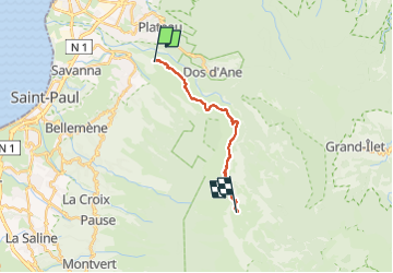
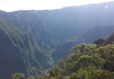
Ruta Senderismo de 17,4 km a descubrir en La Reunión, Desconocido, Saint-Paul. Esta ruta ha sido propuesta por ramagufa.
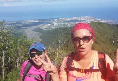
Descripción
Rando en deux jours
premier jour canalisation des orangers vers Roche plate.
Deuxième jour, Roche plate Maïdo parla brèche
Localización
País:
France
Región :
La Reunión
Departamento/provincia :
Desconocido
Municipio :
Saint-Paul
Localidad:
Unknown
Salida:(Dec)
Salida:(UTM)
328105 ; 7679161 (40K) S.
Comentarios
Excursiones cerca
![Excursión Senderismo Saint-Paul - Sans-Souci vers Maido - Photo](https://media.geolcdn.com/t/375/260/ext.jpg?maxdim=2&url=https%3A%2F%2Fservices.sitytrail.com%2FGeolivesWS%2FDownloadMedia.ashx%3FTrailID%3D329852%26Media%3Dfix__20140728124455.jpg)
![Senderismo Senderismo](https://static1.geolcdn.com/sitytour/trail-icons/101.png)
Sans-Souci vers Maido
Senderismo
Medio
(1)
Saint-Paul,
La Reunión,
Desconocido,
France
![](/images/other/stat-length.png)
8,3 km | 18,2 km-effort
4h 33min
![](https://static1.geolcdn.com/siteimages/upload/files/16400158638029165_repeat_loop_refresh_sync_direction_icon.png)
No
![Excursión Senderismo La Possession - Mafate par Dos d'Ane - Aurere - Cayenne - Dos d'Ane - Photo](https://media.geolcdn.com/t/375/260/ext.jpg?maxdim=2&url=https%3A%2F%2Fstatic1.geolcdn.com%2Fsiteimages%2Fupload%2Ffiles%2F1553511878bg_sport_marche.png)
![Senderismo Senderismo](https://static1.geolcdn.com/sitytour/trail-icons/101.png)
Mafate par Dos d'Ane - Aurere - Cayenne - Dos d'Ane
Senderismo
Difícil
(2)
La Possession,
La Reunión,
Desconocido,
France
![](/images/other/stat-length.png)
30 km | 68 km-effort
9h 0min
![](https://static1.geolcdn.com/siteimages/upload/files/16400158638029165_repeat_loop_refresh_sync_direction_icon.png)
Sí
![Excursión Senderismo Saint-Paul - Canalisation des Orangers - Photo](https://media.geolcdn.com/t/375/260/33548ff9-c104-4aa6-a95a-48c5b3d6dd35.jpg&format=jpg&maxdim=2)
![Senderismo Senderismo](https://static1.geolcdn.com/sitytour/trail-icons/101.png)
Canalisation des Orangers
Senderismo
Medio
Saint-Paul,
La Reunión,
Desconocido,
France
![](/images/other/stat-length.png)
16 km | 35 km-effort
4h 30min
![](https://static1.geolcdn.com/siteimages/upload/files/16400158638029165_repeat_loop_refresh_sync_direction_icon.png)
No
![Excursión Quad Saint-Paul - rando 3h - Photo](https://media.geolcdn.com/t/375/260/b82bb2ce-fb44-45c0-bd43-45d47b1e12cb.jpg&format=jpg&maxdim=2)
![Quad Quad](https://static1.geolcdn.com/sitytour/trail-icons/404.png)
![Excursión Senderismo La Possession - Piton fougère - Photo](https://media.geolcdn.com/t/375/260/b48da831-611a-42d8-9e39-3e75692217b7.jpg&format=jpg&maxdim=2)
![Senderismo Senderismo](https://static1.geolcdn.com/sitytour/trail-icons/101.png)
Piton fougère
Senderismo
Medio
La Possession,
La Reunión,
Desconocido,
France
![](/images/other/stat-length.png)
9,7 km | 21 km-effort
3h 2min
![](https://static1.geolcdn.com/siteimages/upload/files/16400158638029165_repeat_loop_refresh_sync_direction_icon.png)
Sí
![Excursión Senderismo La Possession - Vert bouteille - Photo](https://media.geolcdn.com/t/375/260/ext.jpg?maxdim=2&url=https%3A%2F%2Fstatic1.geolcdn.com%2Fsiteimages%2Fupload%2Ffiles%2F1553511878bg_sport_marche.png)
![Senderismo Senderismo](https://static1.geolcdn.com/sitytour/trail-icons/101.png)
Vert bouteille
Senderismo
Muy fácil
(1)
La Possession,
La Reunión,
Desconocido,
France
![](/images/other/stat-length.png)
4 km | 9,6 km-effort
3h 0min
![](https://static1.geolcdn.com/siteimages/upload/files/16400158638029165_repeat_loop_refresh_sync_direction_icon.png)
Sí
![Excursión Senderismo Saint-Paul - Sans Souci - Ilet Alcide - Photo](https://media.geolcdn.com/t/375/260/ext.jpg?maxdim=2&url=https%3A%2F%2Fservices.sitytrail.com%2FGeolivesWS%2FDownloadMedia.ashx%3FTrailID%3D398575%26Media%3D4ec3c696-681a-42bb-954b-4e0439706446.jpg)
![Senderismo Senderismo](https://static1.geolcdn.com/sitytour/trail-icons/101.png)
Sans Souci - Ilet Alcide
Senderismo
Medio
Saint-Paul,
La Reunión,
Desconocido,
France
![](/images/other/stat-length.png)
15,5 km | 31 km-effort
2h 47min
![](https://static1.geolcdn.com/siteimages/upload/files/16400158638029165_repeat_loop_refresh_sync_direction_icon.png)
Sí
![Excursión Senderismo La Possession - Rivière des Galets - Dos d'Ane - Photo](https://media.geolcdn.com/t/375/260/ext.jpg?maxdim=2&url=https%3A%2F%2Fservices.sitytrail.com%2FGeolivesWS%2FDownloadMedia.ashx%3FTrailID%3D381202%26Media%3Db2146de7-968f-4424-9c4e-b2a62bd47053.jpg)
![Senderismo Senderismo](https://static1.geolcdn.com/sitytour/trail-icons/101.png)
Rivière des Galets - Dos d'Ane
Senderismo
Fácil
La Possession,
La Reunión,
Desconocido,
France
![](/images/other/stat-length.png)
13,1 km | 25 km-effort
2h 30min
![](https://static1.geolcdn.com/siteimages/upload/files/16400158638029165_repeat_loop_refresh_sync_direction_icon.png)
Sí
![Excursión Senderismo La Possession - vert bouteille - Photo](https://media.geolcdn.com/t/375/260/ext.jpg?maxdim=2&url=https%3A%2F%2Fservices.sitytrail.com%2FGeolivesWS%2FDownloadMedia.ashx%3FTrailID%3D176800%26Media%3D20130225120229.jpeg)
![Senderismo Senderismo](https://static1.geolcdn.com/sitytour/trail-icons/101.png)
vert bouteille
Senderismo
Muy difícil
La Possession,
La Reunión,
Desconocido,
France
![](/images/other/stat-length.png)
3,9 km | 9,2 km-effort
2h 2min
![](https://static1.geolcdn.com/siteimages/upload/files/16400158638029165_repeat_loop_refresh_sync_direction_icon.png)
Sí