![](/images/other/stat-length.png)
![Excursión Senderismo Fourneaux - Replaton puis vers Loutraz - Photo](https://media.geolcdn.com/t/1900/400/30f0d3b8-9265-46e4-b4f8-85190e0dc7c4.jpg&format=pjpeg&maxdim=2)
Replaton puis vers Loutraz
erjot60
Usuario
![Longitud](/images/other/stat-length.png)
Longitud
7,9 km
![Altitud máxima](https://static1.geolcdn.com/siteimages/upload/files/1508320355ic_sort_altitude_max_24dp.png)
Altitud máxima
1325 m
![Desnivel positivo](https://static1.geolcdn.com/siteimages/upload/files/1508320355ic_sort_den_pos_24dp.png)
Desnivel positivo
297 m
![Km-Effort](/images/other/stat-length.png)
Km-Effort
11,8 km
![Altitud mínima](https://static1.geolcdn.com/siteimages/upload/files/1508320355ic_sort_altitude_min_24dp.png)
Altitud mínima
1051 m
![Desnivel negativo](https://static1.geolcdn.com/siteimages/upload/files/1508320355ic_sort_den_neg_24dp.png)
Desnivel negativo
295 m
![Boucle](https://static1.geolcdn.com/siteimages/upload/files/16400158638029165_repeat_loop_refresh_sync_direction_icon.png)
Boucle
Sí
Fecha de creación :
2023-01-12 11:05:56.0
Última modificación :
2023-01-16 20:17:48.882
![Senderismo](https://static1.geolcdn.com/sitytour/trail-icons/101.png)
3h40
Dificultad : Fácil
![Escanee este código QR para abrir la excursión en la aplicación SityTrail](https://capi.geolives.com/qq0zvz2zws4bq2lad0pu/sitytour/trails/3516604/qr.png?size=200)
Aplicación GPS de excursión GRATIS
A propósito
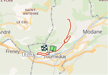
Ruta Senderismo de 7,9 km a descubrir en Auvergne-Rhône-Alpes, Saboya, Fourneaux. Esta ruta ha sido propuesta por erjot60.
Descripción
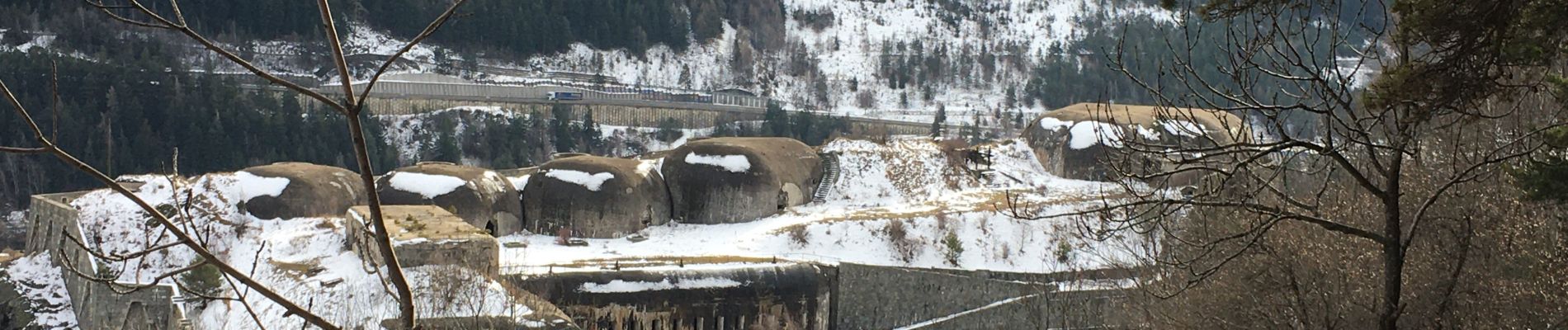
Une petit rando facile jusqu'au fort du Replaton. Prolongation sur le sentier balcon vers Loutraz, mais un chablis dans une zone de forte pente nous empêche de poursuivre jusqu'au Ruisseau du Saint Bernard.
Localización
País:
France
Región :
Auvergne-Rhône-Alpes
Departamento/provincia :
Saboya
Municipio :
Fourneaux
Localidad:
Unknown
Salida:(Dec)
Salida:(UTM)
315243 ; 5006965 (32T) N.
Comentarios
Excursiones cerca
![Excursión Senderismo Modane - Valfrejus refuge du Mont Thabor - Photo](https://media.geolcdn.com/t/375/260/2ea31b81-693a-4382-810b-6d006cdc47b1.jpg&format=jpg&maxdim=2)
![Senderismo Senderismo](https://static1.geolcdn.com/sitytour/trail-icons/101.png)
Valfrejus refuge du Mont Thabor
Senderismo
Medio
(1)
Modane,
Auvergne-Rhône-Alpes,
Saboya,
France
![](/images/other/stat-length.png)
19,4 km | 33 km-effort
6h 32min
![](https://static1.geolcdn.com/siteimages/upload/files/16400158638029165_repeat_loop_refresh_sync_direction_icon.png)
Sí
![Excursión Esquí de fondo Modane - Le Grand Argentier - Photo](https://media.geolcdn.com/t/375/260/e21d4ca1-38c7-443d-8026-c36fbc8a0292.jpg&format=jpg&maxdim=2)
![Esquí de fondo Esquí de fondo](https://static1.geolcdn.com/sitytour/trail-icons/503.png)
Le Grand Argentier
Esquí de fondo
Medio
Modane,
Auvergne-Rhône-Alpes,
Saboya,
France
![](/images/other/stat-length.png)
18,6 km | 37 km-effort
5h 45min
![](https://static1.geolcdn.com/siteimages/upload/files/16400158638029165_repeat_loop_refresh_sync_direction_icon.png)
Sí
![Excursión Esquí de fondo Modane - pointe des sarrasins - Photo](https://media.geolcdn.com/t/375/260/11a876bf-96a7-4155-9789-408cc9cbafaf.jpg&format=jpg&maxdim=2)
![Esquí de fondo Esquí de fondo](https://static1.geolcdn.com/sitytour/trail-icons/503.png)
pointe des sarrasins
Esquí de fondo
Medio
Modane,
Auvergne-Rhône-Alpes,
Saboya,
France
![](/images/other/stat-length.png)
17 km | 35 km-effort
5h 17min
![](https://static1.geolcdn.com/siteimages/upload/files/16400158638029165_repeat_loop_refresh_sync_direction_icon.png)
Sí
![Excursión Esquí de fondo Villarodin-Bourget - passage de la belle Plinier Nord - Photo](https://media.geolcdn.com/t/375/260/24fce6f9-d37e-4224-8f2c-4b95f0071df0.jpg&format=jpg&maxdim=2)
![Esquí de fondo Esquí de fondo](https://static1.geolcdn.com/sitytour/trail-icons/503.png)
passage de la belle Plinier Nord
Esquí de fondo
Medio
Villarodin-Bourget,
Auvergne-Rhône-Alpes,
Saboya,
France
![](/images/other/stat-length.png)
16 km | 37 km-effort
6h 1min
![](https://static1.geolcdn.com/siteimages/upload/files/16400158638029165_repeat_loop_refresh_sync_direction_icon.png)
Sí
![Excursión A pie Villarodin-Bourget - Vallon de l'Orgère - Photo](https://media.geolcdn.com/t/375/260/7808cf41-72f7-4322-acd1-b2150517cd1e.jpeg&format=jpg&maxdim=2)
![A pie A pie](https://static1.geolcdn.com/sitytour/trail-icons/100.png)
Vallon de l'Orgère
A pie
Fácil
Villarodin-Bourget,
Auvergne-Rhône-Alpes,
Saboya,
France
![](/images/other/stat-length.png)
4 km | 5,9 km-effort
1h 19min
![](https://static1.geolcdn.com/siteimages/upload/files/16400158638029165_repeat_loop_refresh_sync_direction_icon.png)
No
![Excursión Esquí de fondo Saint-André - Tête noire en boucle - Photo](https://media.geolcdn.com/t/375/260/0bb3542f-e5da-45e0-a1b0-86c9b0c52fb3.jpg&format=jpg&maxdim=2)
![Esquí de fondo Esquí de fondo](https://static1.geolcdn.com/sitytour/trail-icons/503.png)
Tête noire en boucle
Esquí de fondo
Medio
Saint-André,
Auvergne-Rhône-Alpes,
Saboya,
France
![](/images/other/stat-length.png)
26 km | 51 km-effort
8h 8min
![](https://static1.geolcdn.com/siteimages/upload/files/16400158638029165_repeat_loop_refresh_sync_direction_icon.png)
Sí
![Excursión Raquetas de nieve Saint-André - l Orgere - Photo](https://media.geolcdn.com/t/375/260/68f383ec-1a93-4bdd-ac56-2814b85cf93a.jpg&format=jpg&maxdim=2)
![Raquetas de nieve Raquetas de nieve](https://static1.geolcdn.com/sitytour/trail-icons/504.png)
l Orgere
Raquetas de nieve
Fácil
Saint-André,
Auvergne-Rhône-Alpes,
Saboya,
France
![](/images/other/stat-length.png)
11,7 km | 18,8 km-effort
5h 14min
![](https://static1.geolcdn.com/siteimages/upload/files/16400158638029165_repeat_loop_refresh_sync_direction_icon.png)
Sí
![Excursión Senderismo Modane - mont Thabor - Photo](https://media.geolcdn.com/t/375/260/ext.jpg?maxdim=2&url=https%3A%2F%2Fstatic1.geolcdn.com%2Fsiteimages%2Fupload%2Ffiles%2F1553511878bg_sport_marche.png)
![Senderismo Senderismo](https://static1.geolcdn.com/sitytour/trail-icons/101.png)
mont Thabor
Senderismo
Difícil
(1)
Modane,
Auvergne-Rhône-Alpes,
Saboya,
France
![](/images/other/stat-length.png)
14,3 km | 29 km-effort
6h 24min
![](https://static1.geolcdn.com/siteimages/upload/files/16400158638029165_repeat_loop_refresh_sync_direction_icon.png)
No
![Excursión Senderismo Villarodin-Bourget - La Norma / Télécabine Melezet / Valfréjus - Photo](https://media.geolcdn.com/t/375/260/588a4be4-ac90-41f5-b3fb-9c859be949e5.jpg&format=jpg&maxdim=2)
![Senderismo Senderismo](https://static1.geolcdn.com/sitytour/trail-icons/101.png)
La Norma / Télécabine Melezet / Valfréjus
Senderismo
Difícil
Villarodin-Bourget,
Auvergne-Rhône-Alpes,
Saboya,
France
![](/images/other/stat-length.png)
9,8 km | 22 km-effort
3h 56min
![](https://static1.geolcdn.com/siteimages/upload/files/16400158638029165_repeat_loop_refresh_sync_direction_icon.png)
No