![](/images/other/stat-length.png)
![Excursión Senderismo Saint-Martin-du-Mont - Cestres Francheville par Prairay - Photo](https://media.geolcdn.com/t/1900/400/ext.pjpeg?maxdim=2&url=https%3A%2F%2Fstatic1.geolcdn.com%2Fsiteimages%2Fupload%2Ffiles%2F1553511878bg_sport_marche.png)
Cestres Francheville par Prairay
mricard
Usuario
![Longitud](/images/other/stat-length.png)
Longitud
17,4 km
![Altitud máxima](https://static1.geolcdn.com/siteimages/upload/files/1508320355ic_sort_altitude_max_24dp.png)
Altitud máxima
570 m
![Desnivel positivo](https://static1.geolcdn.com/siteimages/upload/files/1508320355ic_sort_den_pos_24dp.png)
Desnivel positivo
183 m
![Km-Effort](/images/other/stat-length.png)
Km-Effort
19,8 km
![Altitud mínima](https://static1.geolcdn.com/siteimages/upload/files/1508320355ic_sort_altitude_min_24dp.png)
Altitud mínima
476 m
![Desnivel negativo](https://static1.geolcdn.com/siteimages/upload/files/1508320355ic_sort_den_neg_24dp.png)
Desnivel negativo
182 m
![Boucle](https://static1.geolcdn.com/siteimages/upload/files/16400158638029165_repeat_loop_refresh_sync_direction_icon.png)
Boucle
Sí
Fecha de creación :
2023-01-08 19:34:06.649
Última modificación :
2023-01-08 19:43:18.478
![Senderismo](https://static1.geolcdn.com/sitytour/trail-icons/101.png)
3h30
Dificultad : Medio
![Escanee este código QR para abrir la excursión en la aplicación SityTrail](https://capi.geolives.com/qq0zvz2zws4bq2lad0pu/sitytour/trails/3512725/qr.png?size=200)
Aplicación GPS de excursión GRATIS
A propósito
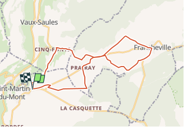
Ruta Senderismo de 17,4 km a descubrir en Borgoña-Franco Condado, Côte-d'Or, Saint-Martin-du-Mont. Esta ruta ha sido propuesta por mricard.
Descripción
Balade sans difficulté permettant de profiter du soleil hivernal en évitant la forêt et donc ... les éventuels secteurs chassés.
Localización
País:
France
Región :
Borgoña-Franco Condado
Departamento/provincia :
Côte-d'Or
Municipio :
Saint-Martin-du-Mont
Localidad:
Unknown
Salida:(Dec)
Salida:(UTM)
635794 ; 5255071 (31T) N.
Comentarios
Excursiones cerca
![Excursión Senderismo Saint-Martin-du-Mont - 12_12_22 - Photo](https://media.geolcdn.com/t/375/260/ext.jpg?maxdim=2&url=https%3A%2F%2Fstatic1.geolcdn.com%2Fsiteimages%2Fupload%2Ffiles%2F1553511878bg_sport_marche.png)
![Senderismo Senderismo](https://static1.geolcdn.com/sitytour/trail-icons/101.png)
12_12_22
Senderismo
Muy difícil
Saint-Martin-du-Mont,
Borgoña-Franco Condado,
Côte-d'Or,
France
![](/images/other/stat-length.png)
48 km | 58 km-effort
7h 11min
![](https://static1.geolcdn.com/siteimages/upload/files/16400158638029165_repeat_loop_refresh_sync_direction_icon.png)
No
![Excursión Senderismo Saint-Martin-du-Mont - Saint Martin du mont Bordes Bricard Prairay - Photo](https://media.geolcdn.com/t/375/260/ext.jpg?maxdim=2&url=https%3A%2F%2Fstatic1.geolcdn.com%2Fsiteimages%2Fupload%2Ffiles%2F1553511878bg_sport_marche.png)
![Senderismo Senderismo](https://static1.geolcdn.com/sitytour/trail-icons/101.png)
Saint Martin du mont Bordes Bricard Prairay
Senderismo
Difícil
Saint-Martin-du-Mont,
Borgoña-Franco Condado,
Côte-d'Or,
France
![](/images/other/stat-length.png)
17,3 km | 20 km-effort
4h 5min
![](https://static1.geolcdn.com/siteimages/upload/files/16400158638029165_repeat_loop_refresh_sync_direction_icon.png)
Sí
![Excursión A pie Vaux-Saules - Vaux Saules Combe St Seine - Photo](https://media.geolcdn.com/t/375/260/ext.jpg?maxdim=2&url=https%3A%2F%2Fstatic1.geolcdn.com%2Fsiteimages%2Fupload%2Ffiles%2F1545311037marcheuse_200dpi.jpg)
![A pie A pie](https://static1.geolcdn.com/sitytour/trail-icons/100.png)
Vaux Saules Combe St Seine
A pie
Fácil
Vaux-Saules,
Borgoña-Franco Condado,
Côte-d'Or,
France
![](/images/other/stat-length.png)
16,6 km | 21 km-effort
4h 0min
![](https://static1.geolcdn.com/siteimages/upload/files/16400158638029165_repeat_loop_refresh_sync_direction_icon.png)
Sí
![Excursión Senderismo Poncey-sur-l'Ignon - Les deux sources - Photo](https://media.geolcdn.com/t/375/260/ext.jpg?maxdim=2&url=https%3A%2F%2Fstatic1.geolcdn.com%2Fsiteimages%2Fupload%2Ffiles%2F1553511878bg_sport_marche.png)
![Senderismo Senderismo](https://static1.geolcdn.com/sitytour/trail-icons/101.png)
Les deux sources
Senderismo
Difícil
Poncey-sur-l'Ignon,
Borgoña-Franco Condado,
Côte-d'Or,
France
![](/images/other/stat-length.png)
10,3 km | 12,9 km-effort
2h 56min
![](https://static1.geolcdn.com/siteimages/upload/files/16400158638029165_repeat_loop_refresh_sync_direction_icon.png)
Sí
![Excursión Enganche Trouhaut - pommard - Photo](https://media.geolcdn.com/t/375/260/ext.jpg?maxdim=2&url=https%3A%2F%2Fstatic1.geolcdn.com%2Fsiteimages%2Fupload%2Ffiles%2F1524743154cheval.jpg)
![Enganche Enganche](https://static1.geolcdn.com/sitytour/trail-icons/302.png)
pommard
Enganche
Muy fácil
Trouhaut,
Borgoña-Franco Condado,
Côte-d'Or,
France
![](/images/other/stat-length.png)
98 km | 126 km-effort
Desconocido
![](https://static1.geolcdn.com/siteimages/upload/files/16400158638029165_repeat_loop_refresh_sync_direction_icon.png)
No
![Excursión Senderismo Champagny - Autour des sources du l'Ignon - Photo](https://media.geolcdn.com/t/375/260/ext.jpg?maxdim=2&url=https%3A%2F%2Fstatic1.geolcdn.com%2Fsiteimages%2Fupload%2Ffiles%2F1553511878bg_sport_marche.png)
![Senderismo Senderismo](https://static1.geolcdn.com/sitytour/trail-icons/101.png)
Autour des sources du l'Ignon
Senderismo
Fácil
Champagny,
Borgoña-Franco Condado,
Côte-d'Or,
France
![](/images/other/stat-length.png)
9,9 km | 13,2 km-effort
2h 28min
![](https://static1.geolcdn.com/siteimages/upload/files/16400158638029165_repeat_loop_refresh_sync_direction_icon.png)
Sí
![Excursión Senderismo Saint-Martin-du-Mont - sentier du bouton d'or - Photo](https://media.geolcdn.com/t/375/260/ext.jpg?maxdim=2&url=https%3A%2F%2Fservices.sitytrail.com%2FGeolivesWS%2FDownloadMedia.ashx%3FTrailID%3D481088%26Media%3Dfix__20151011121046.jpg)
![Senderismo Senderismo](https://static1.geolcdn.com/sitytour/trail-icons/101.png)
sentier du bouton d'or
Senderismo
Fácil
Saint-Martin-du-Mont,
Borgoña-Franco Condado,
Côte-d'Or,
France
![](/images/other/stat-length.png)
21 km | 25 km-effort
4h 14min
![](https://static1.geolcdn.com/siteimages/upload/files/16400158638029165_repeat_loop_refresh_sync_direction_icon.png)
Sí
![Excursión Senderismo Val-Suzon - Val Suzon 30/11/11 - Photo](https://media.geolcdn.com/t/375/260/ext.jpg?maxdim=2&url=https%3A%2F%2Fstatic1.geolcdn.com%2Fsiteimages%2Fupload%2Ffiles%2F1553511878bg_sport_marche.png)
![Senderismo Senderismo](https://static1.geolcdn.com/sitytour/trail-icons/101.png)
Val Suzon 30/11/11
Senderismo
Muy fácil
(1)
Val-Suzon,
Borgoña-Franco Condado,
Côte-d'Or,
France
![](/images/other/stat-length.png)
10,5 km | 12,9 km-effort
2h 30min
![](https://static1.geolcdn.com/siteimages/upload/files/16400158638029165_repeat_loop_refresh_sync_direction_icon.png)
Sí
![Excursión Senderismo Champagny - Champagny GR2 - Photo](https://media.geolcdn.com/t/375/260/ext.jpg?maxdim=2&url=https%3A%2F%2Fstatic1.geolcdn.com%2Fsiteimages%2Fupload%2Ffiles%2F1553511878bg_sport_marche.png)
![Senderismo Senderismo](https://static1.geolcdn.com/sitytour/trail-icons/101.png)
Champagny GR2
Senderismo
Muy difícil
Champagny,
Borgoña-Franco Condado,
Côte-d'Or,
France
![](/images/other/stat-length.png)
16,9 km | 22 km-effort
5h 2min
![](https://static1.geolcdn.com/siteimages/upload/files/16400158638029165_repeat_loop_refresh_sync_direction_icon.png)
No