![](/images/other/stat-length.png)
![Excursión Senderismo Pont-en-Royans - Grotte Balme Rousse - Photo](https://media.geolcdn.com/t/1900/400/3f0931fe-fc35-4723-805e-db75d84253c6.jpg&format=pjpeg&maxdim=2)
Grotte Balme Rousse
cousam
Usuario
![Longitud](/images/other/stat-length.png)
Longitud
15,7 km
![Altitud máxima](https://static1.geolcdn.com/siteimages/upload/files/1508320355ic_sort_altitude_max_24dp.png)
Altitud máxima
862 m
![Desnivel positivo](https://static1.geolcdn.com/siteimages/upload/files/1508320355ic_sort_den_pos_24dp.png)
Desnivel positivo
1233 m
![Km-Effort](/images/other/stat-length.png)
Km-Effort
32 km
![Altitud mínima](https://static1.geolcdn.com/siteimages/upload/files/1508320355ic_sort_altitude_min_24dp.png)
Altitud mínima
199 m
![Desnivel negativo](https://static1.geolcdn.com/siteimages/upload/files/1508320355ic_sort_den_neg_24dp.png)
Desnivel negativo
1216 m
![Boucle](https://static1.geolcdn.com/siteimages/upload/files/16400158638029165_repeat_loop_refresh_sync_direction_icon.png)
Boucle
Sí
Fecha de creación :
2023-01-07 08:38:40.375
Última modificación :
2023-01-08 17:18:50.732
![Senderismo](https://static1.geolcdn.com/sitytour/trail-icons/101.png)
6h43
Dificultad : Difícil
![Escanee este código QR para abrir la excursión en la aplicación SityTrail](https://capi.geolives.com/qq0zvz2zws4bq2lad0pu/sitytour/trails/3512115/qr.png?size=200)
Aplicación GPS de excursión GRATIS
A propósito
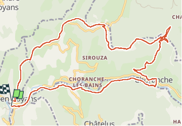
Ruta Senderismo de 15,7 km a descubrir en Auvergne-Rhône-Alpes, Isère, Pont-en-Royans. Esta ruta ha sido propuesta por cousam.
Descripción
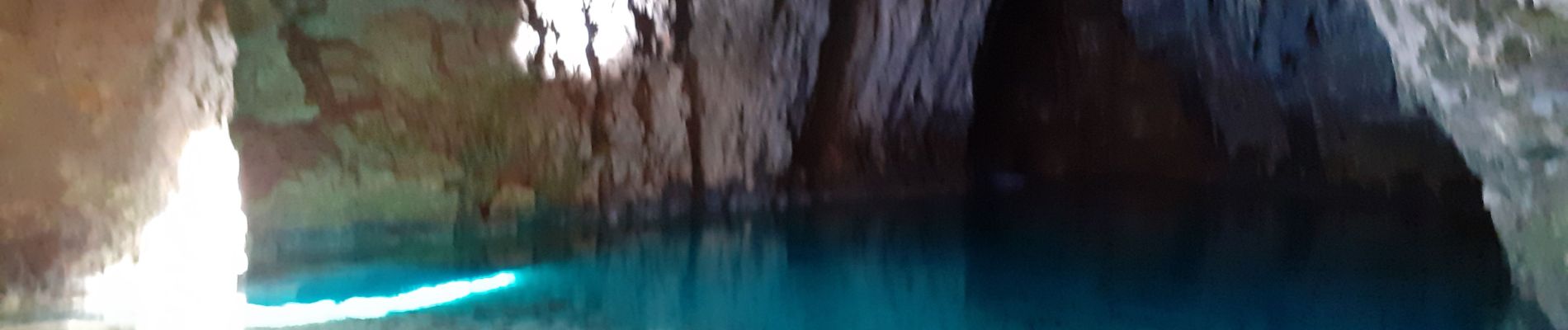
Boucle par la cascade et la grotte Gournier,
apres la grotte de la Balme rousse, passage avec une corde (attention aux cailloux qui peuvent rouler).
Suivre la falaise ,assez Rock n'Roll ,mais sympa ,jusqu'au KM 10.5
Localización
País:
France
Región :
Auvergne-Rhône-Alpes
Departamento/provincia :
Isère
Municipio :
Pont-en-Royans
Localidad:
Unknown
Salida:(Dec)
Salida:(UTM)
684500 ; 4992350 (31T) N.
Comentarios
Excursiones cerca
![Excursión Senderismo Châtelus - Boucle Pas de l'Allier - Pas des Voutes - Photo](https://media.geolcdn.com/t/375/260/ext.jpg?maxdim=2&url=https%3A%2F%2Fservices.sitytrail.com%2FGeolivesWS%2FDownloadMedia.ashx%3FTrailID%3D105085%26Media%3D8675_1.jpg)
![Senderismo Senderismo](https://static1.geolcdn.com/sitytour/trail-icons/101.png)
Boucle Pas de l'Allier - Pas des Voutes
Senderismo
Medio
(1)
Châtelus,
Auvergne-Rhône-Alpes,
Isère,
France
![](/images/other/stat-length.png)
10,1 km | 22 km-effort
4h 30min
![](https://static1.geolcdn.com/siteimages/upload/files/16400158638029165_repeat_loop_refresh_sync_direction_icon.png)
Sí
![Excursión Senderismo Sainte-Eulalie-en-Royans - 26 ste eulalie - Photo](https://media.geolcdn.com/t/375/260/cc17d7c1-039b-4811-aa20-433bfbe37107.jpg&format=jpg&maxdim=2)
![Senderismo Senderismo](https://static1.geolcdn.com/sitytour/trail-icons/101.png)
26 ste eulalie
Senderismo
Medio
Sainte-Eulalie-en-Royans,
Auvergne-Rhône-Alpes,
Drôme,
France
![](/images/other/stat-length.png)
14,8 km | 27 km-effort
6h 43min
![](https://static1.geolcdn.com/siteimages/upload/files/16400158638029165_repeat_loop_refresh_sync_direction_icon.png)
No
![Excursión Senderismo Châtelus - 38 pabro charmatte - Photo](https://media.geolcdn.com/t/375/260/983fca8d-ac95-4180-878f-eb8932bd4279.jpg&format=jpg&maxdim=2)
![Senderismo Senderismo](https://static1.geolcdn.com/sitytour/trail-icons/101.png)
38 pabro charmatte
Senderismo
Difícil
Châtelus,
Auvergne-Rhône-Alpes,
Isère,
France
![](/images/other/stat-length.png)
11,4 km | 29 km-effort
7h 43min
![](https://static1.geolcdn.com/siteimages/upload/files/16400158638029165_repeat_loop_refresh_sync_direction_icon.png)
Sí
![Excursión Senderismo Pont-en-Royans - 38 pont en Royans choranche presles - Photo](https://media.geolcdn.com/t/375/260/55a7031b-27da-4fe2-88f7-a5894b7e1ffc.jpg&format=jpg&maxdim=2)
![Senderismo Senderismo](https://static1.geolcdn.com/sitytour/trail-icons/101.png)
38 pont en Royans choranche presles
Senderismo
Difícil
Pont-en-Royans,
Auvergne-Rhône-Alpes,
Isère,
France
![](/images/other/stat-length.png)
15,4 km | 30 km-effort
6h 52min
![](https://static1.geolcdn.com/siteimages/upload/files/16400158638029165_repeat_loop_refresh_sync_direction_icon.png)
Sí
![Excursión Senderismo Pont-en-Royans - 38 pont en Royans st andre - Photo](https://media.geolcdn.com/t/375/260/9999e3ad-9f99-41dc-bf89-768d521527c3.jpg&format=jpg&maxdim=2)
![Senderismo Senderismo](https://static1.geolcdn.com/sitytour/trail-icons/101.png)
38 pont en Royans st andre
Senderismo
Fácil
Pont-en-Royans,
Auvergne-Rhône-Alpes,
Isère,
France
![](/images/other/stat-length.png)
14,1 km | 19,3 km-effort
3h 33min
![](https://static1.geolcdn.com/siteimages/upload/files/16400158638029165_repeat_loop_refresh_sync_direction_icon.png)
Sí
![Excursión Senderismo Pont-en-Royans - 38 pont en Royans serre cocu - Photo](https://media.geolcdn.com/t/375/260/72853ffa-a2a8-4453-a880-6a63c61d611f.jpg&format=jpg&maxdim=2)
![Senderismo Senderismo](https://static1.geolcdn.com/sitytour/trail-icons/101.png)
38 pont en Royans serre cocu
Senderismo
Medio
Pont-en-Royans,
Auvergne-Rhône-Alpes,
Isère,
France
![](/images/other/stat-length.png)
16 km | 29 km-effort
7h 44min
![](https://static1.geolcdn.com/siteimages/upload/files/16400158638029165_repeat_loop_refresh_sync_direction_icon.png)
Sí
![Excursión Senderismo Châtelus - la grande cournouse - Photo](https://media.geolcdn.com/t/375/260/81ce0c57-e303-433f-a090-0d0401f39630.jpg&format=jpg&maxdim=2)
![Senderismo Senderismo](https://static1.geolcdn.com/sitytour/trail-icons/101.png)
la grande cournouse
Senderismo
Difícil
Châtelus,
Auvergne-Rhône-Alpes,
Isère,
France
![](/images/other/stat-length.png)
10,5 km | 26 km-effort
6h 34min
![](https://static1.geolcdn.com/siteimages/upload/files/16400158638029165_repeat_loop_refresh_sync_direction_icon.png)
Sí
![Excursión Senderismo Choranche - Presles grotte de Gournier et de balme rousse - Photo](https://media.geolcdn.com/t/375/260/6eb5ab9d-f0e8-4fc9-ba43-17ec4e49fbdb.jpg&format=jpg&maxdim=2)
![Senderismo Senderismo](https://static1.geolcdn.com/sitytour/trail-icons/101.png)
Presles grotte de Gournier et de balme rousse
Senderismo
Medio
Choranche,
Auvergne-Rhône-Alpes,
Isère,
France
![](/images/other/stat-length.png)
5,5 km | 14,6 km-effort
3h 19min
![](https://static1.geolcdn.com/siteimages/upload/files/16400158638029165_repeat_loop_refresh_sync_direction_icon.png)
Sí
![Excursión Senderismo Choranche - La Grotte de Choranche - Photo](https://media.geolcdn.com/t/375/260/ext.jpg?maxdim=2&url=https%3A%2F%2Fstatic1.geolcdn.com%2Fsiteimages%2Fupload%2Ffiles%2F1553511878bg_sport_marche.png)
![Senderismo Senderismo](https://static1.geolcdn.com/sitytour/trail-icons/101.png)
La Grotte de Choranche
Senderismo
Difícil
(1)
Choranche,
Auvergne-Rhône-Alpes,
Isère,
France
![](/images/other/stat-length.png)
17,8 km | 33 km-effort
7h 6min
![](https://static1.geolcdn.com/siteimages/upload/files/16400158638029165_repeat_loop_refresh_sync_direction_icon.png)
Sí