![](/images/other/stat-length.png)
![Excursión Senderismo Collonges-sous-Salève - GRAND SALEVE: GROTTES ET SENTIER-BALCON - Photo](https://media.geolcdn.com/t/1900/400/254bcac5-a0fe-43c3-a1c2-202e25644106.jpg&format=pjpeg&maxdim=2)
GRAND SALEVE: GROTTES ET SENTIER-BALCON
djeepee74
Usuario
![Longitud](/images/other/stat-length.png)
![Altitud máxima](https://static1.geolcdn.com/siteimages/upload/files/1508320355ic_sort_altitude_max_24dp.png)
![Desnivel positivo](https://static1.geolcdn.com/siteimages/upload/files/1508320355ic_sort_den_pos_24dp.png)
![Km-Effort](/images/other/stat-length.png)
![Altitud mínima](https://static1.geolcdn.com/siteimages/upload/files/1508320355ic_sort_altitude_min_24dp.png)
![Desnivel negativo](https://static1.geolcdn.com/siteimages/upload/files/1508320355ic_sort_den_neg_24dp.png)
![Boucle](https://static1.geolcdn.com/siteimages/upload/files/16400158638029165_repeat_loop_refresh_sync_direction_icon.png)
![Senderismo](https://static1.geolcdn.com/sitytour/trail-icons/101.png)
4h05
Dificultad : Medio
![Escanee este código QR para abrir la excursión en la aplicación SityTrail](https://capi.geolives.com/qq0zvz2zws4bq2lad0pu/sitytour/trails/3510119/qr.png?size=200)
Aplicación GPS de excursión GRATIS
A propósito
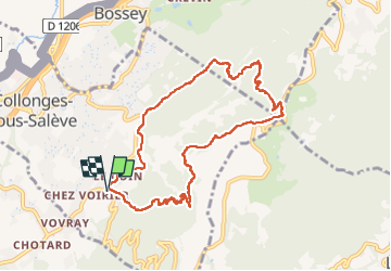
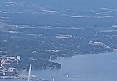
Ruta Senderismo de 9,4 km a descubrir en Auvergne-Rhône-Alpes, Alta Saboya, Collonges-sous-Salève. Esta ruta ha sido propuesta por djeepee74.
Descripción
BOUCLE... live du 20220107
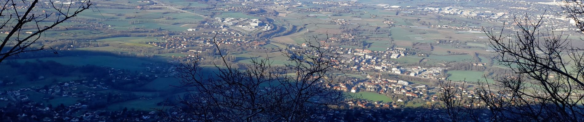
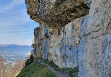
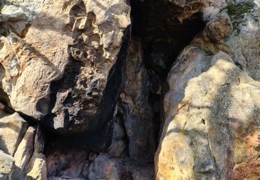
La montée par la grotte d'Orjobet et le sentier-balcon de la Corraterie est un vrai bonheur... escarpé certes, mais faisable sans difficultés.
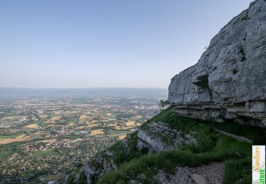
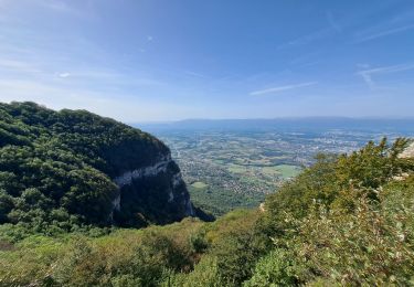
Descente par la Grande Gorge... c'est très raide ! ... et si c'est gras, ce n'est pas une partie de plaisir !
Localización
Comentarios
Excursiones cerca
![Excursión Senderismo Monnetier-Mornex - Salève, circuit par la vire de la Corraterie - Photo](https://media.geolcdn.com/t/375/260/ext.jpg?maxdim=2&url=https%3A%2F%2Fservices.sitytrail.com%2FGeolivesWS%2FDownloadMedia.ashx%3FTrailID%3D172408%26Media%3D13754_1.jpg)
![Senderismo Senderismo](https://static1.geolcdn.com/sitytour/trail-icons/101.png)
Senderismo
![](/images/other/stat-length.png)
![](https://static1.geolcdn.com/siteimages/upload/files/16400158638029165_repeat_loop_refresh_sync_direction_icon.png)
![Excursión A pie Carouge (GE) - De Staël - Place Verte - Photo](https://media.geolcdn.com/t/375/260/097d8cc8-85e9-4d02-9d1d-72c864b74792.jpeg&format=jpg&maxdim=2)
![A pie A pie](https://static1.geolcdn.com/sitytour/trail-icons/100.png)
A pie
![](/images/other/stat-length.png)
![](https://static1.geolcdn.com/siteimages/upload/files/16400158638029165_repeat_loop_refresh_sync_direction_icon.png)
![Excursión Senderismo Collonges-sous-Salève - Le Coin-Grottes d'Orjobet-La Corraterie-Grande Gorge-Le Coin - Photo](https://media.geolcdn.com/t/375/260/aabf5e02-cc0c-4aa0-939a-41b03f824e1c.jpg&format=jpg&maxdim=2)
![Senderismo Senderismo](https://static1.geolcdn.com/sitytour/trail-icons/101.png)
Senderismo
![](/images/other/stat-length.png)
![](https://static1.geolcdn.com/siteimages/upload/files/16400158638029165_repeat_loop_refresh_sync_direction_icon.png)
![Excursión Senderismo La Muraz - La Croisette - Téléphérique - Photo](https://media.geolcdn.com/t/375/260/bbb7530c-646b-4278-a608-5976a2ccf5a8.jpg&format=jpg&maxdim=2)
![Senderismo Senderismo](https://static1.geolcdn.com/sitytour/trail-icons/101.png)
Senderismo
![](/images/other/stat-length.png)
![](https://static1.geolcdn.com/siteimages/upload/files/16400158638029165_repeat_loop_refresh_sync_direction_icon.png)
![Excursión Senderismo Monnetier-Mornex - sentier de la Sauge - Photo](https://media.geolcdn.com/t/375/260/c35518be-b219-456a-b639-b0d81d9789ec.jpg&format=jpg&maxdim=2)
![Senderismo Senderismo](https://static1.geolcdn.com/sitytour/trail-icons/101.png)
Senderismo
![](/images/other/stat-length.png)
![](https://static1.geolcdn.com/siteimages/upload/files/16400158638029165_repeat_loop_refresh_sync_direction_icon.png)
![Excursión Senderismo Collonges-sous-Salève - Le Salève en boucle, orjobet , corraterie, belvédère, grande gorge - Photo](https://media.geolcdn.com/t/375/260/201bd548-abfc-4c16-8a26-ab36aa21dc20.jpg&format=jpg&maxdim=2)
![Senderismo Senderismo](https://static1.geolcdn.com/sitytour/trail-icons/101.png)
Senderismo
![](/images/other/stat-length.png)
![](https://static1.geolcdn.com/siteimages/upload/files/16400158638029165_repeat_loop_refresh_sync_direction_icon.png)
![Excursión Senderismo Collonges-sous-Salève - SALEVE - Photo](https://media.geolcdn.com/t/375/260/7cbc3f40-5ee2-427e-bcb6-ff3543321705.jpg&format=jpg&maxdim=2)
![Senderismo Senderismo](https://static1.geolcdn.com/sitytour/trail-icons/101.png)
Senderismo
![](/images/other/stat-length.png)
![](https://static1.geolcdn.com/siteimages/upload/files/16400158638029165_repeat_loop_refresh_sync_direction_icon.png)
![Excursión Senderismo Collonges-sous-Salève - Le salave .on arrive a collonge sur saleve et on part du parking du coin - Photo](https://media.geolcdn.com/t/375/260/a3d25805-d970-493f-96be-6281e606aba7.jpg&format=jpg&maxdim=2)
![Senderismo Senderismo](https://static1.geolcdn.com/sitytour/trail-icons/101.png)
Senderismo
![](/images/other/stat-length.png)
![](https://static1.geolcdn.com/siteimages/upload/files/16400158638029165_repeat_loop_refresh_sync_direction_icon.png)
![Excursión Senderismo Arbusigny - 23-04-2022 Arbusigny-Reignier - Photo](https://media.geolcdn.com/t/375/260/5e483365-d1f7-4dc5-8093-01b6f142e63f.jpg&format=jpg&maxdim=2)
![Senderismo Senderismo](https://static1.geolcdn.com/sitytour/trail-icons/101.png)
Senderismo
![](/images/other/stat-length.png)
![](https://static1.geolcdn.com/siteimages/upload/files/16400158638029165_repeat_loop_refresh_sync_direction_icon.png)