


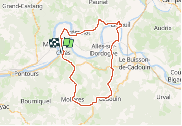

13,5 km | 17,9 km-effort


Usuario


Aplicación GPS de excursión GRATIS
 SityTrail
IGN / Institutos geográficos
SityTrail World
El mundo es suyo
Ruta Bici de montaña de 33 km a descubrir en Nueva Aquitania, Dordogne, Calès. Esta ruta ha sido propuesta por amelie14.
Principalement de la route sur ce circuit (seulement une portion de chemin herbeux) où le VTT est appréciable pour le confort et le braquet dans le dénivelé positif :-)
Senderismo

Senderismo

Senderismo
Senderismo
Senderismo
Senderismo
Senderismo
Senderismo
Senderismo