![](/images/other/stat-length.png)
![Excursión Carrera Le Tampon - trail Bras de la Plaine - Photo](https://media.geolcdn.com/t/1900/400/ext.pjpeg?maxdim=2&url=https%3A%2F%2Fstatic1.geolcdn.com%2Fsiteimages%2Fupload%2Ffiles%2F1524743154running.jpg)
trail Bras de la Plaine
francejpp
Usuario
![Longitud](/images/other/stat-length.png)
Longitud
9,6 km
![Altitud máxima](https://static1.geolcdn.com/siteimages/upload/files/1508320355ic_sort_altitude_max_24dp.png)
Altitud máxima
779 m
![Desnivel positivo](https://static1.geolcdn.com/siteimages/upload/files/1508320355ic_sort_den_pos_24dp.png)
Desnivel positivo
747 m
![Km-Effort](/images/other/stat-length.png)
Km-Effort
19,6 km
![Altitud mínima](https://static1.geolcdn.com/siteimages/upload/files/1508320355ic_sort_altitude_min_24dp.png)
Altitud mínima
243 m
![Desnivel negativo](https://static1.geolcdn.com/siteimages/upload/files/1508320355ic_sort_den_neg_24dp.png)
Desnivel negativo
743 m
![Boucle](https://static1.geolcdn.com/siteimages/upload/files/16400158638029165_repeat_loop_refresh_sync_direction_icon.png)
Boucle
Sí
Fecha de creación :
2016-03-09 00:00:00.0
Última modificación :
2016-03-09 00:00:00.0
![Carrera](https://static1.geolcdn.com/sitytour/trail-icons/103.png)
2h44
Dificultad : Medio
![Escanee este código QR para abrir la excursión en la aplicación SityTrail](https://capi.geolives.com/qq0zvz2zws4bq2lad0pu/sitytour/trails/348440/qr.png?size=200)
Aplicación GPS de excursión GRATIS
A propósito
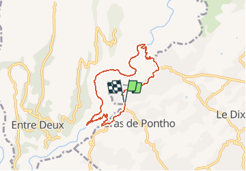
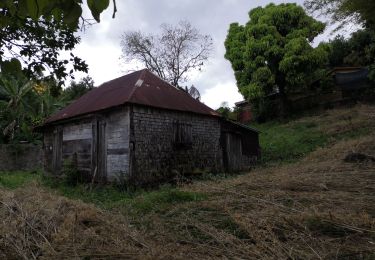
Ruta Carrera de 9,6 km a descubrir en La Reunión, Desconocido, Le Tampon. Esta ruta ha sido propuesta por francejpp.
Descripción
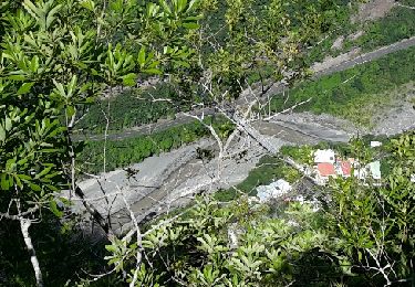
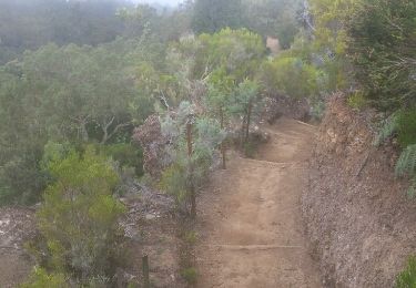
Départ du stade municipal de bras de Pontho descendre vers le chemin Dassy, pont de la liane, la riviere,îlet Canelle, la crête, la caver de la petite Ravine, remonté vers Pont d'Yves, redescente au stade
Localización
País:
France
Región :
La Reunión
Departamento/provincia :
Desconocido
Municipio :
Le Tampon
Localidad:
Unknown
Salida:(Dec)
Salida:(UTM)
343572 ; 7650151 (40K) S.
Comentarios
Excursiones cerca
![Excursión Senderismo Entre-Deux - La Réunion - Le Dimitile (aller-retour) par le sentier de la chapelle. - Photo](https://media.geolcdn.com/t/375/260/ext.jpg?maxdim=2&url=https%3A%2F%2Fservices.sitytrail.com%2FGeolivesWS%2FDownloadMedia.ashx%3FTrailID%3D449274%26Media%3Dfix__20150724090014.jpg)
![Senderismo Senderismo](https://static1.geolcdn.com/sitytour/trail-icons/101.png)
La Réunion - Le Dimitile (aller-retour) par le sentier de la chapelle.
Senderismo
Medio
(1)
Entre-Deux,
La Reunión,
Desconocido,
France
![](/images/other/stat-length.png)
11,9 km | 24 km-effort
5h 29min
![](https://static1.geolcdn.com/siteimages/upload/files/16400158638029165_repeat_loop_refresh_sync_direction_icon.png)
Sí
![Excursión Senderismo Entre-Deux - boucle citrons galets - Photo](https://media.geolcdn.com/t/375/260/ext.jpg?maxdim=2&url=https%3A%2F%2Fservices.sitytrail.com%2FGeolivesWS%2FDownloadMedia.ashx%3FTrailID%3D361878%26Media%3D20141111140014.jpg)
![Senderismo Senderismo](https://static1.geolcdn.com/sitytour/trail-icons/101.png)
boucle citrons galets
Senderismo
Medio
(1)
Entre-Deux,
La Reunión,
Desconocido,
France
![](/images/other/stat-length.png)
17,4 km | 33 km-effort
6h 50min
![](https://static1.geolcdn.com/siteimages/upload/files/16400158638029165_repeat_loop_refresh_sync_direction_icon.png)
Sí
![Excursión Senderismo Entre-Deux - Jacky Inard jusqu'à la 1ere echelle - Photo](https://media.geolcdn.com/t/375/260/ext.jpg?maxdim=2&url=https%3A%2F%2Fmedia.geolcdn.com%2Ff%2F52d3adaa-62d7-4e1e-b244-a796f216ad55.jpg)
![Senderismo Senderismo](https://static1.geolcdn.com/sitytour/trail-icons/101.png)
Jacky Inard jusqu'à la 1ere echelle
Senderismo
Muy difícil
Entre-Deux,
La Reunión,
Desconocido,
France
![](/images/other/stat-length.png)
17 km | 37 km-effort
8h 19min
![](https://static1.geolcdn.com/siteimages/upload/files/16400158638029165_repeat_loop_refresh_sync_direction_icon.png)
Sí
![Excursión Senderismo Entre-Deux - L'entre deux l'arche naturelle - Photo](https://media.geolcdn.com/t/375/260/ext.jpg?maxdim=2&url=https%3A%2F%2Fmedia.geolcdn.com%2Ff%2F97df8922-278d-4182-a00a-9f6e37f5b72a.jpg)
![Senderismo Senderismo](https://static1.geolcdn.com/sitytour/trail-icons/101.png)
L'entre deux l'arche naturelle
Senderismo
Medio
Entre-Deux,
La Reunión,
Desconocido,
France
![](/images/other/stat-length.png)
11,3 km | 22 km-effort
2h 38min
![](https://static1.geolcdn.com/siteimages/upload/files/16400158638029165_repeat_loop_refresh_sync_direction_icon.png)
No
![Excursión Senderismo Entre-Deux - Coteau Sec Entre-Deux - Photo](https://media.geolcdn.com/t/375/260/ext.jpg?maxdim=2&url=https%3A%2F%2Fservices.sitytrail.com%2FGeolivesWS%2FDownloadMedia.ashx%3FTrailID%3D398067%26Media%3Dfix__20150320093901.jpg)
![Senderismo Senderismo](https://static1.geolcdn.com/sitytour/trail-icons/101.png)
Coteau Sec Entre-Deux
Senderismo
Fácil
(2)
Entre-Deux,
La Reunión,
Desconocido,
France
![](/images/other/stat-length.png)
4,7 km | 7,9 km-effort
2h 17min
![](https://static1.geolcdn.com/siteimages/upload/files/16400158638029165_repeat_loop_refresh_sync_direction_icon.png)
Sí
![Excursión Senderismo Entre-Deux - Bayonne retour zèbre - Photo](https://media.geolcdn.com/t/375/260/ext.jpg?maxdim=2&url=https%3A%2F%2Fstatic1.geolcdn.com%2Fsiteimages%2Fupload%2Ffiles%2F1553511878bg_sport_marche.png)
![Senderismo Senderismo](https://static1.geolcdn.com/sitytour/trail-icons/101.png)
Bayonne retour zèbre
Senderismo
Difícil
(1)
Entre-Deux,
La Reunión,
Desconocido,
France
![](/images/other/stat-length.png)
16,4 km | 38 km-effort
8h 0min
![](https://static1.geolcdn.com/siteimages/upload/files/16400158638029165_repeat_loop_refresh_sync_direction_icon.png)
No
![Excursión Senderismo Le Tampon - Sentier Dassy ( Tampon) - Photo](https://media.geolcdn.com/t/375/260/ext.jpg?maxdim=2&url=https%3A%2F%2Fstatic1.geolcdn.com%2Fsiteimages%2Fupload%2Ffiles%2F1553511878bg_sport_marche.png)
![Senderismo Senderismo](https://static1.geolcdn.com/sitytour/trail-icons/101.png)
Sentier Dassy ( Tampon)
Senderismo
Medio
(1)
Le Tampon,
La Reunión,
Desconocido,
France
![](/images/other/stat-length.png)
5,6 km | 12,3 km-effort
1h 25min
![](https://static1.geolcdn.com/siteimages/upload/files/16400158638029165_repeat_loop_refresh_sync_direction_icon.png)
Sí
![Excursión Senderismo Entre-Deux - La Réunion - Boucle de l'Entre-Deux par les sentiers - Photo](https://media.geolcdn.com/t/375/260/ext.jpg?maxdim=2&url=https%3A%2F%2Fservices.sitytrail.com%2FGeolivesWS%2FDownloadMedia.ashx%3FTrailID%3D318786%26Media%3Dfix__20140626152140.jpg)
![Senderismo Senderismo](https://static1.geolcdn.com/sitytour/trail-icons/101.png)
La Réunion - Boucle de l'Entre-Deux par les sentiers
Senderismo
Medio
(1)
Entre-Deux,
La Reunión,
Desconocido,
France
![](/images/other/stat-length.png)
12,6 km | 21 km-effort
4h 4min
![](https://static1.geolcdn.com/siteimages/upload/files/16400158638029165_repeat_loop_refresh_sync_direction_icon.png)
Sí
![Excursión Senderismo Entre-Deux - joli tour au dessus d'entre d'eux - Photo](https://media.geolcdn.com/t/375/260/ext.jpg?maxdim=2&url=https%3A%2F%2Fservices.sitytrail.com%2FGeolivesWS%2FDownloadMedia.ashx%3FTrailID%3D232551%26Media%3Dfix__20131114113649.jpg)
![Senderismo Senderismo](https://static1.geolcdn.com/sitytour/trail-icons/101.png)
joli tour au dessus d'entre d'eux
Senderismo
Fácil
Entre-Deux,
La Reunión,
Desconocido,
France
![](/images/other/stat-length.png)
11,5 km | 24 km-effort
3h 51min
![](https://static1.geolcdn.com/siteimages/upload/files/16400158638029165_repeat_loop_refresh_sync_direction_icon.png)
Sí