![](/images/other/stat-length.png)
![Excursión Senderismo La Bégude-de-Mazenc - 2022-12-16_06h47m47_tmpWriteApidae_109527_fr - Photo](https://media.geolcdn.com/t/1900/400/66dc9f4a-2c73-41db-b648-f89e0384c7b2.jpg&format=pjpeg&maxdim=2)
2022-12-16_06h47m47_tmpWriteApidae_109527_fr
chancha
Usuario GUIDE
![Longitud](/images/other/stat-length.png)
![Altitud máxima](https://static1.geolcdn.com/siteimages/upload/files/1508320355ic_sort_altitude_max_24dp.png)
![Desnivel positivo](https://static1.geolcdn.com/siteimages/upload/files/1508320355ic_sort_den_pos_24dp.png)
![Km-Effort](/images/other/stat-length.png)
![Altitud mínima](https://static1.geolcdn.com/siteimages/upload/files/1508320355ic_sort_altitude_min_24dp.png)
![Desnivel negativo](https://static1.geolcdn.com/siteimages/upload/files/1508320355ic_sort_den_neg_24dp.png)
![Boucle](https://static1.geolcdn.com/siteimages/upload/files/16400158638029165_repeat_loop_refresh_sync_direction_icon.png)
![Senderismo](https://static1.geolcdn.com/sitytour/trail-icons/101.png)
6h25
Dificultad : Difícil
![Escanee este código QR para abrir la excursión en la aplicación SityTrail](https://capi.geolives.com/qq0zvz2zws4bq2lad0pu/sitytour/trails/3482164/qr.png?size=200)
Aplicación GPS de excursión GRATIS
A propósito
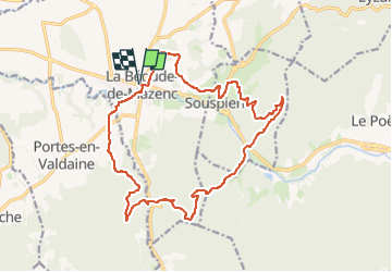
Ruta Senderismo de 19,7 km a descubrir en Auvergne-Rhône-Alpes, Drôme, La Bégude-de-Mazenc. Esta ruta ha sido propuesta por chancha.
Descripción
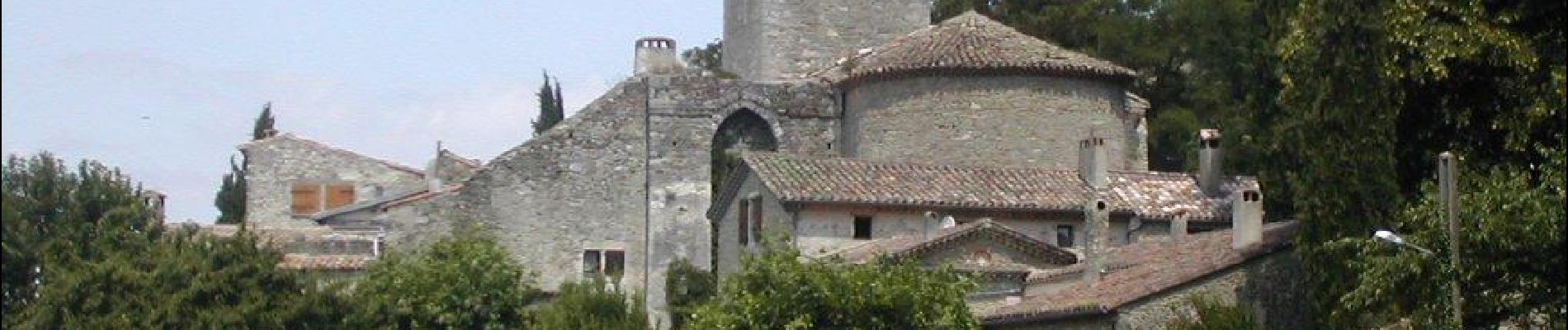
Boucle qui permet de découvrir les multiples paysages des alentours de la Bégude ainsi que le vieux village de Châteauneuf. Principalement en sous-bois, cette randonnée longue mais sans difficulté technique sera très agréable en été.
Localización
Comentarios
Excursiones cerca
![Excursión Senderismo Portes-en-Valdaine - 2022-10-01_17h32m32_13243364-1 - Photo](https://media.geolcdn.com/t/375/260/2ea09867-c31b-46c1-94ae-201697a2583c.jpg&format=jpg&maxdim=2)
![Senderismo Senderismo](https://static1.geolcdn.com/sitytour/trail-icons/101.png)
Senderismo
![](/images/other/stat-length.png)
![](https://static1.geolcdn.com/siteimages/upload/files/16400158638029165_repeat_loop_refresh_sync_direction_icon.png)
![Excursión Senderismo Portes-en-Valdaine - Portes-en-Valdaine Serre-de-Mirabel 11km. - Photo](https://media.geolcdn.com/t/375/260/89334076-0011-4fd6-a9cb-db05a56205b4.jpg&format=jpg&maxdim=2)
![Senderismo Senderismo](https://static1.geolcdn.com/sitytour/trail-icons/101.png)
Senderismo
![](/images/other/stat-length.png)
![](https://static1.geolcdn.com/siteimages/upload/files/16400158638029165_repeat_loop_refresh_sync_direction_icon.png)
![Excursión Senderismo Saint-Gervais-sur-Roubion - 2022-10-01_17h25m59_GPX-Moutette-St-Rome-STGervais - Photo](https://media.geolcdn.com/t/375/260/6b20cd10-00dc-411b-8b77-04281c5b5149.jpg&format=jpg&maxdim=2)
![Senderismo Senderismo](https://static1.geolcdn.com/sitytour/trail-icons/101.png)
Senderismo
![](/images/other/stat-length.png)
![](https://static1.geolcdn.com/siteimages/upload/files/16400158638029165_repeat_loop_refresh_sync_direction_icon.png)
![Excursión Senderismo Portes-en-Valdaine - GPX-Rando-Plaine-Portoise-nouvelleversion - Photo](https://media.geolcdn.com/t/375/260/521ae53d-ced6-46fa-9655-4eb3952c25ee.jpg&format=jpg&maxdim=2)
![Senderismo Senderismo](https://static1.geolcdn.com/sitytour/trail-icons/101.png)
Senderismo
![](/images/other/stat-length.png)
![](https://static1.geolcdn.com/siteimages/upload/files/16400158638029165_repeat_loop_refresh_sync_direction_icon.png)
![Excursión Senderismo La Touche - La Touche Crêtes de l'ysard 12km. - Photo](https://media.geolcdn.com/t/375/260/b7717e93-9def-4e5d-8328-3e96528d5925.jpg&format=jpg&maxdim=2)
![Senderismo Senderismo](https://static1.geolcdn.com/sitytour/trail-icons/101.png)
Senderismo
![](/images/other/stat-length.png)
![](https://static1.geolcdn.com/siteimages/upload/files/16400158638029165_repeat_loop_refresh_sync_direction_icon.png)
![Excursión Senderismo La Bégude-de-Mazenc - 2022-12-16_08h55m45_tmpWriteApidae_269688_fr-1 - Photo](https://media.geolcdn.com/t/375/260/c6c6d47d-2b27-4a95-a6a2-66f0defa82f3.jpg&format=jpg&maxdim=2)
![Senderismo Senderismo](https://static1.geolcdn.com/sitytour/trail-icons/101.png)
Senderismo
![](/images/other/stat-length.png)
![](https://static1.geolcdn.com/siteimages/upload/files/16400158638029165_repeat_loop_refresh_sync_direction_icon.png)
![Excursión Senderismo La Touche - La Touche : Les Citelles et Serre Pointu 12km - Photo](https://media.geolcdn.com/t/375/260/6be75cc0-9945-4cf3-b3f9-69a08db1d316.jpg&format=jpg&maxdim=2)
![Senderismo Senderismo](https://static1.geolcdn.com/sitytour/trail-icons/101.png)
Senderismo
![](/images/other/stat-length.png)
![](https://static1.geolcdn.com/siteimages/upload/files/16400158638029165_repeat_loop_refresh_sync_direction_icon.png)
![Excursión Senderismo La Touche - La Touche Mastaize 9km - Photo](https://media.geolcdn.com/t/375/260/7617f59d-4270-4583-9eab-9f2081c0076a.jpg&format=jpg&maxdim=2)
![Senderismo Senderismo](https://static1.geolcdn.com/sitytour/trail-icons/101.png)
Senderismo
![](/images/other/stat-length.png)
![](https://static1.geolcdn.com/siteimages/upload/files/16400158638029165_repeat_loop_refresh_sync_direction_icon.png)
![Excursión Senderismo Portes-en-Valdaine - 26 portes en valdaine - Photo](https://media.geolcdn.com/t/375/260/b3cf4f19-20f2-4a60-8f05-2283f4c73166.jpg&format=jpg&maxdim=2)
![Senderismo Senderismo](https://static1.geolcdn.com/sitytour/trail-icons/101.png)
Senderismo
![](/images/other/stat-length.png)
![](https://static1.geolcdn.com/siteimages/upload/files/16400158638029165_repeat_loop_refresh_sync_direction_icon.png)