![](/images/other/stat-length.png)
![Excursión Senderismo Boulogne-Billancourt - Parcours des années 30 - Photo](https://media.geolcdn.com/t/1900/400/ext.pjpeg?maxdim=2&url=https%3A%2F%2Fstatic1.geolcdn.com%2Fsiteimages%2Fupload%2Ffiles%2F1553511878bg_sport_marche.png)
Parcours des années 30
Randos du mercredi
Le mercredi c'est rando
![Longitud](/images/other/stat-length.png)
![Altitud máxima](https://static1.geolcdn.com/siteimages/upload/files/1508320355ic_sort_altitude_max_24dp.png)
![Desnivel positivo](https://static1.geolcdn.com/siteimages/upload/files/1508320355ic_sort_den_pos_24dp.png)
![Km-Effort](/images/other/stat-length.png)
![Altitud mínima](https://static1.geolcdn.com/siteimages/upload/files/1508320355ic_sort_altitude_min_24dp.png)
![Desnivel negativo](https://static1.geolcdn.com/siteimages/upload/files/1508320355ic_sort_den_neg_24dp.png)
![Boucle](https://static1.geolcdn.com/siteimages/upload/files/16400158638029165_repeat_loop_refresh_sync_direction_icon.png)
![Senderismo](https://static1.geolcdn.com/sitytour/trail-icons/101.png)
1h18
Dificultad : Fácil
![Escanee este código QR para abrir la excursión en la aplicación SityTrail](https://capi.geolives.com/qq0zvz2zws4bq2lad0pu/sitytour/trails/3481842/qr.png?size=200)
Aplicación GPS de excursión GRATIS
A propósito
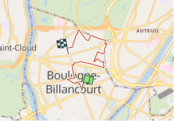
Ruta Senderismo de 5,2 km a descubrir en Isla de Francia, Altos del Sena, Boulogne-Billancourt. Esta ruta ha sido propuesta por Randos du mercredi.
Descripción
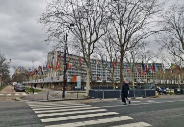
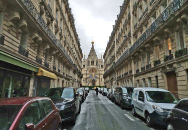
Parcours dessiné par la ville de Boulogne afin de mettre en valeur un riche patrimoine bâti des années 30 et du à l'imagination de grands architectes tels le Corbusier, Courrèges, Mallet-Stevens etc...
Ce parcours fait honneur au mouvement créatif de l'entre deux guerres
Puntos de interés
Localización
Comentarios
Excursiones cerca
![Excursión Senderismo Chaville - Le Sentier des 7 étangs - Photo](https://media.geolcdn.com/t/375/260/ext.jpg?maxdim=2&url=https%3A%2F%2Fservices.sitytrail.com%2FGeolivesWS%2FDownloadMedia.ashx%3FTrailID%3D110203%26Media%3D5435_1.jpg)
![Senderismo Senderismo](https://static1.geolcdn.com/sitytour/trail-icons/101.png)
Senderismo
![](/images/other/stat-length.png)
![](https://static1.geolcdn.com/siteimages/upload/files/16400158638029165_repeat_loop_refresh_sync_direction_icon.png)
![Excursión Senderismo Chaville - GRP CV-IDF 20R Chaville à Vaucresson - Photo](https://media.geolcdn.com/t/375/260/ee9d0d3a-696b-449f-af8b-f1928f5c8b40.jpg&format=jpg&maxdim=2)
![Senderismo Senderismo](https://static1.geolcdn.com/sitytour/trail-icons/101.png)
Senderismo
![](/images/other/stat-length.png)
![](https://static1.geolcdn.com/siteimages/upload/files/16400158638029165_repeat_loop_refresh_sync_direction_icon.png)
![Excursión Senderismo París - DP75-13 De Vaugirard à Sèvres-Babylone - Photo](https://media.geolcdn.com/t/375/260/ef3b90ff-736f-49ef-8953-54f5a63f322a.jpg&format=jpg&maxdim=2)
![Senderismo Senderismo](https://static1.geolcdn.com/sitytour/trail-icons/101.png)
Senderismo
![](/images/other/stat-length.png)
![](https://static1.geolcdn.com/siteimages/upload/files/16400158638029165_repeat_loop_refresh_sync_direction_icon.png)
![Excursión Senderismo París - DP75-11 De Boulainvilliers à pont du Garigliano - Photo](https://media.geolcdn.com/t/375/260/65f6b9b8-257b-4cb3-ae12-0b82159348dc.jpg&format=jpg&maxdim=2)
![Senderismo Senderismo](https://static1.geolcdn.com/sitytour/trail-icons/101.png)
Senderismo
![](/images/other/stat-length.png)
![](https://static1.geolcdn.com/siteimages/upload/files/16400158638029165_repeat_loop_refresh_sync_direction_icon.png)
![Excursión Senderismo París - DP75-32 De Charles-Michel à Plaisance - Photo](https://media.geolcdn.com/t/375/260/392c6463-e03b-44f3-85b1-02c32ee10469.jpg&format=jpg&maxdim=2)
![Senderismo Senderismo](https://static1.geolcdn.com/sitytour/trail-icons/101.png)
Senderismo
![](/images/other/stat-length.png)
![](https://static1.geolcdn.com/siteimages/upload/files/16400158638029165_repeat_loop_refresh_sync_direction_icon.png)
![Excursión Senderismo París - DP75-31 De Passy à Charles-Michel - Photo](https://media.geolcdn.com/t/375/260/96431e96-6d3c-47dc-91ae-d446da1f3a1d.jpg&format=jpg&maxdim=2)
![Senderismo Senderismo](https://static1.geolcdn.com/sitytour/trail-icons/101.png)
Senderismo
![](/images/other/stat-length.png)
![](https://static1.geolcdn.com/siteimages/upload/files/16400158638029165_repeat_loop_refresh_sync_direction_icon.png)
![Excursión Senderismo París - DP75-19 de Porte-Maillot à Europe - Photo](https://media.geolcdn.com/t/375/260/159be267-b3d1-40ca-b7c5-4227580bd0ba.jpg&format=jpg&maxdim=2)
![Senderismo Senderismo](https://static1.geolcdn.com/sitytour/trail-icons/101.png)
Senderismo
![](/images/other/stat-length.png)
![](https://static1.geolcdn.com/siteimages/upload/files/16400158638029165_repeat_loop_refresh_sync_direction_icon.png)
![Excursión Bicicleta París - Paris au bord de Seine - Photo](https://media.geolcdn.com/t/375/260/ext.jpg?maxdim=2&url=https%3A%2F%2Fservices.sitytrail.com%2FGeolivesWS%2FDownloadMedia.ashx%3FTrailID%3D137119%26Media%3D20120703185331.jpg)
![Bicicleta Bicicleta](https://static1.geolcdn.com/sitytour/trail-icons/200.png)
Bicicleta
![](/images/other/stat-length.png)
![](https://static1.geolcdn.com/siteimages/upload/files/16400158638029165_repeat_loop_refresh_sync_direction_icon.png)
![Excursión Senderismo París - 75-05-Paris les Boulevards 13km-625-799- - Photo](https://media.geolcdn.com/t/375/260/65e75e6a-35fa-4760-a028-d929907d2fd8.jpg&format=jpg&maxdim=2)
![Senderismo Senderismo](https://static1.geolcdn.com/sitytour/trail-icons/101.png)
Senderismo
![](/images/other/stat-length.png)
![](https://static1.geolcdn.com/siteimages/upload/files/16400158638029165_repeat_loop_refresh_sync_direction_icon.png)