![](/images/other/stat-length.png)
![Excursión Senderismo Saint-Raphaël - SityTrail - 3468614 - col-lentisquexpic-aurellexmal-infernetxcol-notre-dame - Photo](https://media.geolcdn.com/t/1900/400/ext.pjpeg?maxdim=2&url=https%3A%2F%2Fstatic1.geolcdn.com%2Fsiteimages%2Fupload%2Ffiles%2F1553511878bg_sport_marche.png)
SityTrail - 3468614 - col-lentisquexpic-aurellexmal-infernetxcol-notre-dame
clarambre
Usuario
![Longitud](/images/other/stat-length.png)
Longitud
13,9 km
![Altitud máxima](https://static1.geolcdn.com/siteimages/upload/files/1508320355ic_sort_altitude_max_24dp.png)
Altitud máxima
323 m
![Desnivel positivo](https://static1.geolcdn.com/siteimages/upload/files/1508320355ic_sort_den_pos_24dp.png)
Desnivel positivo
504 m
![Km-Effort](/images/other/stat-length.png)
Km-Effort
21 km
![Altitud mínima](https://static1.geolcdn.com/siteimages/upload/files/1508320355ic_sort_altitude_min_24dp.png)
Altitud mínima
29 m
![Desnivel negativo](https://static1.geolcdn.com/siteimages/upload/files/1508320355ic_sort_den_neg_24dp.png)
Desnivel negativo
504 m
![Boucle](https://static1.geolcdn.com/siteimages/upload/files/16400158638029165_repeat_loop_refresh_sync_direction_icon.png)
Boucle
Sí
Fecha de creación :
2022-11-28 14:21:04.494
Última modificación :
2022-11-28 14:41:17.549
![Senderismo](https://static1.geolcdn.com/sitytour/trail-icons/101.png)
4h30
Dificultad : Difícil
![Escanee este código QR para abrir la excursión en la aplicación SityTrail](https://capi.geolives.com/qq0zvz2zws4bq2lad0pu/sitytour/trails/3468646/qr.png?size=200)
Aplicación GPS de excursión GRATIS
A propósito
Ruta Senderismo de 13,9 km a descubrir en Provenza-Alpes-Costa Azul, Var, Saint-Raphaël. Esta ruta ha sido propuesta por clarambre.
Descripción
Départ du parking du Col des Lentisques pour une boucle en passant par le Col Notre Dame, Le Ravin du Mal Infernet et retour par le GR 52 Ravin des Lentisques
On peut pour le plaisir effectuer un aller retour au Pic d'Aurelle
Localización
País:
France
Región :
Provenza-Alpes-Costa Azul
Departamento/provincia :
Var
Municipio :
Saint-Raphaël
Localidad:
Unknown
Salida:(Dec)
Salida:(UTM)
330849 ; 4815138 (32T) N.
Comentarios
Excursiones cerca
![Excursión Senderismo Saint-Raphaël - Massif d'ésterel-grande boucle pic cap roux - Photo](https://media.geolcdn.com/t/375/260/75f5531d-898d-4f51-8086-6652c6aad722.jpg&format=jpg&maxdim=2)
![Senderismo Senderismo](https://static1.geolcdn.com/sitytour/trail-icons/101.png)
Massif d'ésterel-grande boucle pic cap roux
Senderismo
Medio
(2)
Saint-Raphaël,
Provenza-Alpes-Costa Azul,
Var,
France
![](/images/other/stat-length.png)
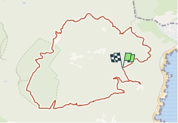
10,4 km | 17,5 km-effort
2h 58min
![](https://static1.geolcdn.com/siteimages/upload/files/16400158638029165_repeat_loop_refresh_sync_direction_icon.png)
Sí
![Excursión Senderismo Saint-Raphaël - Le tour du Pic du Cap Roux - St Raphaël (Agay) - Photo](https://media.geolcdn.com/t/375/260/ext.jpg?maxdim=2&url=https%3A%2F%2Fservices.sitytrail.com%2FGeolivesWS%2FDownloadMedia.ashx%3FTrailID%3D317929%26Media%3D17353_6.jpg)
![Senderismo Senderismo](https://static1.geolcdn.com/sitytour/trail-icons/101.png)
Le tour du Pic du Cap Roux - St Raphaël (Agay)
Senderismo
Medio
(2)
Saint-Raphaël,
Provenza-Alpes-Costa Azul,
Var,
France
![](/images/other/stat-length.png)
7,2 km | 12,8 km-effort
2h 0min
![](https://static1.geolcdn.com/siteimages/upload/files/16400158638029165_repeat_loop_refresh_sync_direction_icon.png)
Sí
![Excursión Senderismo Saint-Raphaël - Pic du Cap Roux - Photo](https://media.geolcdn.com/t/375/260/ext.jpg?maxdim=2&url=https%3A%2F%2Fservices.sitytrail.com%2FGeolivesWS%2FDownloadMedia.ashx%3FTrailID%3D230669%26Media%3Dfix__20131103111411.jpg)
![Senderismo Senderismo](https://static1.geolcdn.com/sitytour/trail-icons/101.png)
Pic du Cap Roux
Senderismo
Muy fácil
(4)
Saint-Raphaël,
Provenza-Alpes-Costa Azul,
Var,
France
![](/images/other/stat-length.png)
4,1 km | 7,8 km-effort
1h 17min
![](https://static1.geolcdn.com/siteimages/upload/files/16400158638029165_repeat_loop_refresh_sync_direction_icon.png)
Sí
![Excursión Senderismo Saint-Raphaël - SityTrail - ND - Aiguille - Photo](https://media.geolcdn.com/t/375/260/ext.jpg?maxdim=2&url=https%3A%2F%2Fstatic1.geolcdn.com%2Fsiteimages%2Fupload%2Ffiles%2F1553511878bg_sport_marche.png)
![Senderismo Senderismo](https://static1.geolcdn.com/sitytour/trail-icons/101.png)
SityTrail - ND - Aiguille
Senderismo
Muy difícil
(1)
Saint-Raphaël,
Provenza-Alpes-Costa Azul,
Var,
France
![](/images/other/stat-length.png)
18,1 km | 29 km-effort
6h 40min
![](https://static1.geolcdn.com/siteimages/upload/files/16400158638029165_repeat_loop_refresh_sync_direction_icon.png)
Sí
![Excursión Senderismo Saint-Raphaël - Agay - Sainte-Barbe - Étang des Nénuphares - Photo](https://media.geolcdn.com/t/375/260/dfb7073a-02d4-4811-84ba-99dc2878a0d2.jpg&format=jpg&maxdim=2)
![Senderismo Senderismo](https://static1.geolcdn.com/sitytour/trail-icons/101.png)
Agay - Sainte-Barbe - Étang des Nénuphares
Senderismo
Fácil
(2)
Saint-Raphaël,
Provenza-Alpes-Costa Azul,
Var,
France
![](/images/other/stat-length.png)
5 km | 6,2 km-effort
2h 8min
![](https://static1.geolcdn.com/siteimages/upload/files/16400158638029165_repeat_loop_refresh_sync_direction_icon.png)
Sí
![Excursión Senderismo Saint-Raphaël - Tour du Pic de l'Ours - Le Trayas - Photo](https://media.geolcdn.com/t/375/260/ext.jpg?maxdim=2&url=https%3A%2F%2Fservices.sitytrail.com%2FGeolivesWS%2FDownloadMedia.ashx%3FTrailID%3D191486%26Media%3D15078_2.jpg)
![Senderismo Senderismo](https://static1.geolcdn.com/sitytour/trail-icons/101.png)
Tour du Pic de l'Ours - Le Trayas
Senderismo
Medio
(1)
Saint-Raphaël,
Provenza-Alpes-Costa Azul,
Var,
France
![](/images/other/stat-length.png)
9,5 km | 16 km-effort
3h 0min
![](https://static1.geolcdn.com/siteimages/upload/files/16400158638029165_repeat_loop_refresh_sync_direction_icon.png)
Sí
![Excursión Senderismo Saint-Raphaël - Rando des Etangs - Photo](https://media.geolcdn.com/t/375/260/33bb8feb-dce4-4c92-bacc-ea49f2230fc9.jpg&format=jpg&maxdim=2)
![Senderismo Senderismo](https://static1.geolcdn.com/sitytour/trail-icons/101.png)
Rando des Etangs
Senderismo
Muy difícil
Saint-Raphaël,
Provenza-Alpes-Costa Azul,
Var,
France
![](/images/other/stat-length.png)
16,1 km | 22 km-effort
4h 1min
![](https://static1.geolcdn.com/siteimages/upload/files/16400158638029165_repeat_loop_refresh_sync_direction_icon.png)
Sí
![Excursión Senderismo Saint-Raphaël - Dent et Pic de l'Ours - Pic d'Aurelle depuis le Col Belle Barbe - Photo](https://media.geolcdn.com/t/375/260/4303c42f-248d-490a-8d87-48bd2cb53ff8.jpg&format=jpg&maxdim=2)
![Senderismo Senderismo](https://static1.geolcdn.com/sitytour/trail-icons/101.png)
Dent et Pic de l'Ours - Pic d'Aurelle depuis le Col Belle Barbe
Senderismo
Difícil
Saint-Raphaël,
Provenza-Alpes-Costa Azul,
Var,
France
![](/images/other/stat-length.png)
17,5 km | 25 km-effort
4h 50min
![](https://static1.geolcdn.com/siteimages/upload/files/16400158638029165_repeat_loop_refresh_sync_direction_icon.png)
Sí
![Excursión Senderismo Saint-Raphaël - Le tour du Perthus Oriental 2 - Photo](https://media.geolcdn.com/t/375/260/58751db2-2f84-478b-945a-f0594731e6ca.jpg&format=jpg&maxdim=2)
![Senderismo Senderismo](https://static1.geolcdn.com/sitytour/trail-icons/101.png)
Le tour du Perthus Oriental 2
Senderismo
Difícil
Saint-Raphaël,
Provenza-Alpes-Costa Azul,
Var,
France
![](/images/other/stat-length.png)
11,2 km | 14,8 km-effort
3h 21min
![](https://static1.geolcdn.com/siteimages/upload/files/16400158638029165_repeat_loop_refresh_sync_direction_icon.png)
Sí