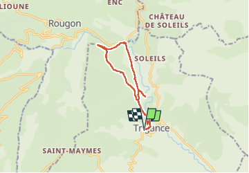
![](/images/other/stat-length.png)
![Excursión Senderismo Trigance - Trigance, Pont de Sautet, Clue de Carejuan - Photo](https://media.geolcdn.com/t/1900/400/1dc61dcc-3f4e-441d-8260-ccd5372d47f3.jpg&format=pjpeg&maxdim=2)
Trigance, Pont de Sautet, Clue de Carejuan
GrouGary
Usuario
![Longitud](/images/other/stat-length.png)
![Altitud máxima](https://static1.geolcdn.com/siteimages/upload/files/1508320355ic_sort_altitude_max_24dp.png)
![Desnivel positivo](https://static1.geolcdn.com/siteimages/upload/files/1508320355ic_sort_den_pos_24dp.png)
![Km-Effort](/images/other/stat-length.png)
![Altitud mínima](https://static1.geolcdn.com/siteimages/upload/files/1508320355ic_sort_altitude_min_24dp.png)
![Desnivel negativo](https://static1.geolcdn.com/siteimages/upload/files/1508320355ic_sort_den_neg_24dp.png)
![Boucle](https://static1.geolcdn.com/siteimages/upload/files/16400158638029165_repeat_loop_refresh_sync_direction_icon.png)
![Senderismo](https://static1.geolcdn.com/sitytour/trail-icons/101.png)
3h02
Dificultad : Muy fácil
![Escanee este código QR para abrir la excursión en la aplicación SityTrail](https://capi.geolives.com/qq0zvz2zws4bq2lad0pu/sitytour/trails/3468115/qr.png?size=200)
Aplicación GPS de excursión GRATIS
A propósito
Ruta Senderismo de 12,4 km a descubrir en Provenza-Alpes-Costa Azul, Var, Trigance. Esta ruta ha sido propuesta por GrouGary.
Descripción
Petite rando pour journée hivernale, courte, sans difficulté, sur terrain peu pentu.
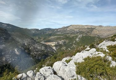
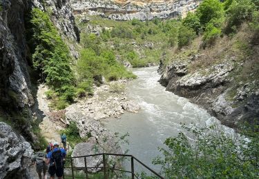
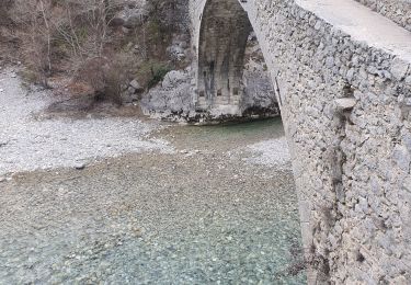
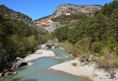
Remarquables : Le ballet d'une vingtaine de vautours dans les creux de la falaise de la clue de Carejuan, après le Pont de Carejuan où le Jabron se jette dans le Verdon. Le magnifique Pont du Sautet sur un Jabron quasi à sec, laissant voir les belles "marmites" creusées par les roches qui tourbillonnent, ainsi que les parois raides et profondes creusées par l'érosion de l'eau.
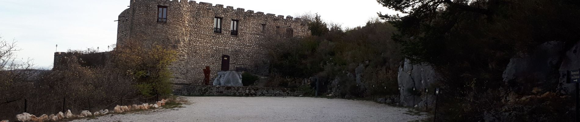
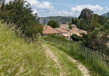
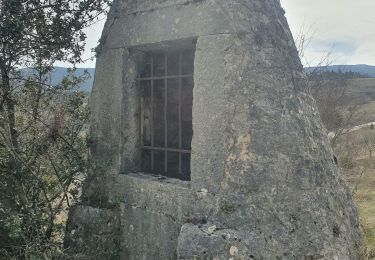
Petit village de Trigance, son château et sa boulangerie-patisserie ouverte le WE
Localización
Comentarios
Excursiones cerca
![Excursión Senderismo Rougon - Gorges du Verdon - de Point Sublime vers Encastel - AR - Photo](https://media.geolcdn.com/t/375/260/ext.jpg?maxdim=2&url=https%3A%2F%2Fservices.sitytrail.com%2FGeolivesWS%2FDownloadMedia.ashx%3FTrailID%3D346532%26Media%3Dfix__20140919102850.jpg)
![Senderismo Senderismo](https://static1.geolcdn.com/sitytour/trail-icons/101.png)
Senderismo
![](/images/other/stat-length.png)
![](https://static1.geolcdn.com/siteimages/upload/files/16400158638029165_repeat_loop_refresh_sync_direction_icon.png)
![Excursión Senderismo Rougon - Sentier Martel.Gorges du Verdon.06 05 16 - Photo](https://media.geolcdn.com/t/375/260/ext.jpg?maxdim=2&url=https%3A%2F%2Fservices.sitytrail.com%2FGeolivesWS%2FDownloadMedia.ashx%3FTrailID%3D565642%26Media%3Dfix__20160506150757.jpg)
![Senderismo Senderismo](https://static1.geolcdn.com/sitytour/trail-icons/101.png)
Senderismo
![](/images/other/stat-length.png)
![](https://static1.geolcdn.com/siteimages/upload/files/16400158638029165_repeat_loop_refresh_sync_direction_icon.png)
![Excursión Senderismo Trigance - Pont du Carajuan Rougon Pont du Tusset Belvédère de Rancoumas Trace réelle - Photo](https://media.geolcdn.com/t/375/260/0d9be621-f74c-4e9c-86b6-3e1c9c92569d.jpg&format=jpg&maxdim=2)
![Senderismo Senderismo](https://static1.geolcdn.com/sitytour/trail-icons/101.png)
Senderismo
![](/images/other/stat-length.png)
![](https://static1.geolcdn.com/siteimages/upload/files/16400158638029165_repeat_loop_refresh_sync_direction_icon.png)
![Excursión Senderismo Trigance - Trigance : Rancoumas-Carajuan - Photo](https://media.geolcdn.com/t/375/260/05e6b860-df1f-428f-8277-8650dc3b7bdf.jpg&format=jpg&maxdim=2)
![Senderismo Senderismo](https://static1.geolcdn.com/sitytour/trail-icons/101.png)
Senderismo
![](/images/other/stat-length.png)
![](https://static1.geolcdn.com/siteimages/upload/files/16400158638029165_repeat_loop_refresh_sync_direction_icon.png)
![Excursión Senderismo Rougon - Mourre du chanier par rougon Réél - Photo](https://media.geolcdn.com/t/375/260/012183d2-9b95-47e6-8342-def03e6aa442.jpg&format=jpg&maxdim=2)
![Senderismo Senderismo](https://static1.geolcdn.com/sitytour/trail-icons/101.png)
Senderismo
![](/images/other/stat-length.png)
![](https://static1.geolcdn.com/siteimages/upload/files/16400158638029165_repeat_loop_refresh_sync_direction_icon.png)
![Excursión Senderismo Rougon - Point sublime Verdon Blanc Martel 12 km - Photo](https://media.geolcdn.com/t/375/260/7151e3a3-b423-4b55-88c4-a120b42dbc2f.jpg&format=jpg&maxdim=2)
![Senderismo Senderismo](https://static1.geolcdn.com/sitytour/trail-icons/101.png)
Senderismo
![](/images/other/stat-length.png)
![](https://static1.geolcdn.com/siteimages/upload/files/16400158638029165_repeat_loop_refresh_sync_direction_icon.png)
![Excursión Senderismo Trigance - 2023-03-07 Belvédère des vautours - Photo](https://media.geolcdn.com/t/375/260/0d06071b-f845-42c2-8a64-fcf3d10e6149.jpg&format=jpg&maxdim=2)
![Senderismo Senderismo](https://static1.geolcdn.com/sitytour/trail-icons/101.png)
Senderismo
![](/images/other/stat-length.png)
![](https://static1.geolcdn.com/siteimages/upload/files/16400158638029165_repeat_loop_refresh_sync_direction_icon.png)
![Excursión Senderismo Rougon - 2023-02-24 Pont de Tusset - Rancoumas - Entreverges - Photo](https://media.geolcdn.com/t/375/260/95d9c943-b4ce-4d81-89ff-82c5f7b78e7d.jpg&format=jpg&maxdim=2)
![Senderismo Senderismo](https://static1.geolcdn.com/sitytour/trail-icons/101.png)
Senderismo
![](/images/other/stat-length.png)
![](https://static1.geolcdn.com/siteimages/upload/files/16400158638029165_repeat_loop_refresh_sync_direction_icon.png)
![Senderismo Senderismo](https://static1.geolcdn.com/sitytour/trail-icons/101.png)
Senderismo
![](/images/other/stat-length.png)
![](https://static1.geolcdn.com/siteimages/upload/files/16400158638029165_repeat_loop_refresh_sync_direction_icon.png)