![](/images/other/stat-length.png)
![Excursión Senderismo Rochefourchat - Rochefourchat (ASPTT) - Photo](https://media.geolcdn.com/t/1900/400/1fdac6b0-e9dc-4a61-aa39-771c68602c4b.jpg&format=pjpeg&maxdim=2)
Rochefourchat (ASPTT)
TOULAUDIN
Usuario
![Longitud](/images/other/stat-length.png)
Longitud
14 km
![Altitud máxima](https://static1.geolcdn.com/siteimages/upload/files/1508320355ic_sort_altitude_max_24dp.png)
Altitud máxima
1499 m
![Desnivel positivo](https://static1.geolcdn.com/siteimages/upload/files/1508320355ic_sort_den_pos_24dp.png)
Desnivel positivo
792 m
![Km-Effort](/images/other/stat-length.png)
Km-Effort
25 km
![Altitud mínima](https://static1.geolcdn.com/siteimages/upload/files/1508320355ic_sort_altitude_min_24dp.png)
Altitud mínima
840 m
![Desnivel negativo](https://static1.geolcdn.com/siteimages/upload/files/1508320355ic_sort_den_neg_24dp.png)
Desnivel negativo
795 m
![Boucle](https://static1.geolcdn.com/siteimages/upload/files/16400158638029165_repeat_loop_refresh_sync_direction_icon.png)
Boucle
Sí
Fecha de creación :
2022-11-27 08:37:15.417
Última modificación :
2022-11-30 11:08:34.652
![Senderismo](https://static1.geolcdn.com/sitytour/trail-icons/101.png)
5h42
Dificultad : Medio
![Escanee este código QR para abrir la excursión en la aplicación SityTrail](https://capi.geolives.com/qq0zvz2zws4bq2lad0pu/sitytour/trails/3467869/qr.png?size=200)
Aplicación GPS de excursión GRATIS
A propósito
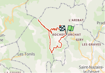
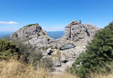
Ruta Senderismo de 14 km a descubrir en Auvergne-Rhône-Alpes, Drôme, Rochefourchat. Esta ruta ha sido propuesta por TOULAUDIN.
Descripción
trace rando enregistrée le 27/11/22 .très beau parcours pas de difficultés ,complémentaire du Grand delmas .
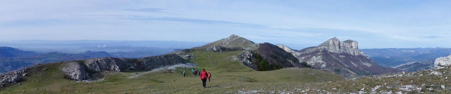
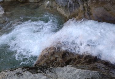
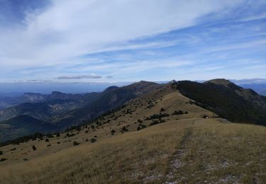
Localización
País:
France
Región :
Auvergne-Rhône-Alpes
Departamento/provincia :
Drôme
Municipio :
Rochefourchat
Localidad:
Unknown
Salida:(Dec)
Salida:(UTM)
678321 ; 4940768 (31T) N.
Comentarios
Excursiones cerca
![Excursión Senderismo La Chaudière - Les 3 Becs - Photo](https://media.geolcdn.com/t/375/260/ext.jpg?maxdim=2&url=https%3A%2F%2Fservices.sitytrail.com%2FGeolivesWS%2FDownloadMedia.ashx%3FTrailID%3D218224%26Media%3Dfix__20130901120821.jpg)
![Senderismo Senderismo](https://static1.geolcdn.com/sitytour/trail-icons/101.png)
Les 3 Becs
Senderismo
Medio
(1)
La Chaudière,
Auvergne-Rhône-Alpes,
Drôme,
France
![](/images/other/stat-length.png)
10,3 km | 21 km-effort
5h 37min
![](https://static1.geolcdn.com/siteimages/upload/files/16400158638029165_repeat_loop_refresh_sync_direction_icon.png)
Sí
![Excursión Senderismo La Chaudière - La chaudiere - chapelle des Sadoux - Photo](https://media.geolcdn.com/t/375/260/fe29fe3e-8696-4fc7-af92-f6d3eeb26877.jpg&format=jpg&maxdim=2)
![Senderismo Senderismo](https://static1.geolcdn.com/sitytour/trail-icons/101.png)
La chaudiere - chapelle des Sadoux
Senderismo
Muy fácil
(2)
La Chaudière,
Auvergne-Rhône-Alpes,
Drôme,
France
![](/images/other/stat-length.png)
11,1 km | 18,2 km-effort
3h 47min
![](https://static1.geolcdn.com/siteimages/upload/files/16400158638029165_repeat_loop_refresh_sync_direction_icon.png)
Sí
![Excursión Senderismo Saint-Nazaire-le-Désert - 26 st Nazaire le desert - Photo](https://media.geolcdn.com/t/375/260/800f793b-c8e6-438c-bf52-c0a833bbf3e1.jpg&format=jpg&maxdim=2)
![Senderismo Senderismo](https://static1.geolcdn.com/sitytour/trail-icons/101.png)
26 st Nazaire le desert
Senderismo
Muy difícil
Saint-Nazaire-le-Désert,
Auvergne-Rhône-Alpes,
Drôme,
France
![](/images/other/stat-length.png)
8,5 km | 16 km-effort
5h 17min
![](https://static1.geolcdn.com/siteimages/upload/files/16400158638029165_repeat_loop_refresh_sync_direction_icon.png)
No
![Excursión Senderismo La Chaudière - les 3becs et arches - Photo](https://media.geolcdn.com/t/375/260/97464636-1260-4d97-b592-83a9cda2a983.jpg&format=jpg&maxdim=2)
![Senderismo Senderismo](https://static1.geolcdn.com/sitytour/trail-icons/101.png)
les 3becs et arches
Senderismo
Difícil
La Chaudière,
Auvergne-Rhône-Alpes,
Drôme,
France
![](/images/other/stat-length.png)
15,3 km | 31 km-effort
5h 10min
![](https://static1.geolcdn.com/siteimages/upload/files/16400158638029165_repeat_loop_refresh_sync_direction_icon.png)
Sí
![Excursión Senderismo La Chaudière - les trois becs - Photo](https://media.geolcdn.com/t/375/260/ext.jpg?maxdim=2&url=https%3A%2F%2Fservices.sitytrail.com%2FGeolivesWS%2FDownloadMedia.ashx%3FTrailID%3D997850%26Media%3Dfix__20180701153419.jpg)
![Senderismo Senderismo](https://static1.geolcdn.com/sitytour/trail-icons/101.png)
les trois becs
Senderismo
Medio
La Chaudière,
Auvergne-Rhône-Alpes,
Drôme,
France
![](/images/other/stat-length.png)
11,7 km | 23 km-effort
6h 25min
![](https://static1.geolcdn.com/siteimages/upload/files/16400158638029165_repeat_loop_refresh_sync_direction_icon.png)
Sí
![Excursión Senderismo Saint-Nazaire-le-Désert - Bergerie du Pradaux - Photo](https://media.geolcdn.com/t/375/260/ext.jpg?maxdim=2&url=https%3A%2F%2Fstatic1.geolcdn.com%2Fsiteimages%2Fupload%2Ffiles%2F1553511878bg_sport_marche.png)
![Senderismo Senderismo](https://static1.geolcdn.com/sitytour/trail-icons/101.png)
Bergerie du Pradaux
Senderismo
Medio
(1)
Saint-Nazaire-le-Désert,
Auvergne-Rhône-Alpes,
Drôme,
France
![](/images/other/stat-length.png)
12,5 km | 22 km-effort
4h 42min
![](https://static1.geolcdn.com/siteimages/upload/files/16400158638029165_repeat_loop_refresh_sync_direction_icon.png)
Sí
![Excursión Senderismo La Chaudière - La chaudière- chapelle des Sadoux - Photo](https://media.geolcdn.com/t/375/260/6819e1ce-f278-49e2-9b64-8d59d930cfa9.jpg&format=jpg&maxdim=2)
![Senderismo Senderismo](https://static1.geolcdn.com/sitytour/trail-icons/101.png)
La chaudière- chapelle des Sadoux
Senderismo
Medio
La Chaudière,
Auvergne-Rhône-Alpes,
Drôme,
France
![](/images/other/stat-length.png)
11,3 km | 17,6 km-effort
3h 7min
![](https://static1.geolcdn.com/siteimages/upload/files/16400158638029165_repeat_loop_refresh_sync_direction_icon.png)
Sí
![Excursión Senderismo Rochefourchat - Serre Délégué depuis Rochefourchat 15 10 23 - Photo](https://media.geolcdn.com/t/375/260/dd32defb-f16e-4dda-98b5-10da95afa891.jpg&format=jpg&maxdim=2)
![Senderismo Senderismo](https://static1.geolcdn.com/sitytour/trail-icons/101.png)
Serre Délégué depuis Rochefourchat 15 10 23
Senderismo
Medio
Rochefourchat,
Auvergne-Rhône-Alpes,
Drôme,
France
![](/images/other/stat-length.png)
14,3 km | 25 km-effort
4h 29min
![](https://static1.geolcdn.com/siteimages/upload/files/16400158638029165_repeat_loop_refresh_sync_direction_icon.png)
Sí
![Excursión Senderismo La Chaudière - 070823 Boucle des 3 Becs - Photo](https://media.geolcdn.com/t/375/260/f23626ff-2b3a-4052-a8ea-d683a57533b0.jpg&format=jpg&maxdim=2)
![Senderismo Senderismo](https://static1.geolcdn.com/sitytour/trail-icons/101.png)
070823 Boucle des 3 Becs
Senderismo
Muy difícil
La Chaudière,
Auvergne-Rhône-Alpes,
Drôme,
France
![](/images/other/stat-length.png)
11,4 km | 23 km-effort
4h 58min
![](https://static1.geolcdn.com/siteimages/upload/files/16400158638029165_repeat_loop_refresh_sync_direction_icon.png)
Sí